Country:
 Turkey
Region:
City:
Latitude and Longitude:
Time Zone:
Postal Code:
IP information under different IP Channel
ip-api
Country
IPinfo
Country
MaxMind
Country
Luminati
Country
TRASN
Time Zone
Europe/Istanbul
ISP
Medianova Internet Hizmetleri Ve Ticaret Anonim Sirketi
Latitude
Longitude
Postal
db-ip
Country
ipdata
Country
Popular places and events near this IP address
New Rome
Ancient nickname for the city of Byzantium, later known as Constantinople (modern Istanbul)
Distance: Approx. 492 meters
Latitude and longitude: 41.01388889,28.95555556
New Rome (Greek: Νέα Ῥώμη, Néa Rhṓmē; Koinē Greek: [ˈne̞a ˈr̥o̞ːme̞ː]; Latin: Nova Roma; Late Latin: [ˈnɔwa ˈroma]) was the original name given by the Roman emperor Constantine the Great to his new imperial capital in 330 CE, which was built as an expansion of the city of Byzantium on the European coast of the Bosporus strait. The city was founded as Byzantion (Greek: Βυζάντιον) by Megarian colonists in 657 BCE. It was renamed by Constantine the Great first as "New Rome" (Nova Roma) during the official dedication of the city as the new Roman capital in 330 CE, which he soon afterwards changed to Constantinople (Constantinopolis). The city was officially renamed as Istanbul in the 20th century, after the establishment of the Turkish Republic in 1923.

Istanbul
Largest city in Turkey
Distance: Approx. 446 meters
Latitude and longitude: 41.01361111,28.955
Istanbul is the largest city in Turkey, straddling the Bosporus Strait, the boundary between Europe and Asia. It is considered the country's economic, cultural and historic capital. The city has a population of over 15 million residents, comprising 19% of the population of Turkey, and is the most populous city in Europe and the world's fifteenth-largest city.

Column of Marcian
Monumental column in Istanbul, Turkey
Distance: Approx. 188 meters
Latitude and longitude: 41.01543,28.9503
The Column of Marcian (Greek: Στήλη του Μαρκιανού, Turkish: Kıztaşı) is a Roman honorific column erected in Constantinople by the praefectus urbi Tatianus (450 – c. 452) and dedicated to the Emperor Marcian (450–57). It is located in the present-day Fatih district of Istanbul.

Aksaray, Fatih
Neighbourhood in Fatih, Istanbul, Turkey
Distance: Approx. 496 meters
Latitude and longitude: 41.01,28.95277778
Aksaray (literally "White Palace" in Turkish) is a neighbourhood in the municipality and district of Fatih, Istanbul Province, Turkey. Its population is 8,541 (2022). It is so named because it was founded by migrants from Aksaray in central Turkey, brought here in the 15th century by Mehmet II to repopulate the city after its conquest.
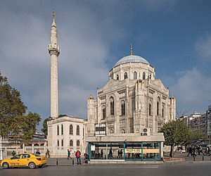
Pertevniyal Valide Sultan Mosque
Mosque in Istanbul, Turkey
Distance: Approx. 508 meters
Latitude and longitude: 41.01,28.95305556
The Pertevniyal Valide Sultan Mosque, also known as the Aksaray Valide Mosque (Turkish: Pertevniyal Valide Sultan Camii, Aksaray Valide Sultan Camii), is a grand Ottoman imperial mosque in Istanbul, Turkey. It is located at the intersection of Ordu Street and Atatürk Boulevard in the Aksaray neighborhood beside the Pertevniyal High School (Turkish: Pertevniyal Lisesi) which was also built by the order of Sultana Pertevniyal in 1872. The mosque attracts 400-500 worshipers during regular prayer times and over 2,500 worshipers during Friday prayers.

Church of St. Polyeuctus
Byzantine church in Istanbul
Distance: Approx. 278 meters
Latitude and longitude: 41.014,28.953
The Church of St. Polyeuctus (Greek: Ἅγιος Πολύευκτος, translit. Hagios Polyeuktos; Turkish: Ayios Polieuktos Kilisesi) was an ancient Byzantine church in Constantinople (now Istanbul, Turkey) built by the noblewoman Anicia Juliana and dedicated to Saint Polyeuctus.

Aviation Martyrs' Monument
Military monument in Turkey
Distance: Approx. 426 meters
Latitude and longitude: 41.0156,28.95418
The Aviation Martyrs' Monument (Turkish: Hava Şehitleri Anıtı or formerly Tayyare Şehitleri Abidesi), located in Fatih district of Istanbul, Turkey, is a memorial dedicated to the first soldiers of the Ottoman Airforce to be killed in flight accidents. In Turkey, one use of the term "martyr" is as an honorific for people killed in action during war. The monument was commissioned right after the consecutive crash of two monoplanes in Palestine, killing three of the four military aviators who were on an expedition flight from Istanbul to Alexandria in early 1914.
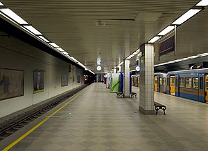
Aksaray (Istanbul Metro)
Station of the Istanbul Metro
Distance: Approx. 308 meters
Latitude and longitude: 41.0111,28.9489
Aksaray is a rapid transit station on the M1 line of the Istanbul Metro. It is located in central Fatih under Adnan Menderes Boulevard near Aksaray square. Aksaray was opened on 3 September 1989 as part of the first rapid transit line in Istanbul and Turkey.

İskender Pasha Mosque, Fatih
Mosque in Fatih, Istanbul, Turkey
Distance: Approx. 354 meters
Latitude and longitude: 41.01667,28.94788
İskender Pasha Mosque (Turkish: İskender Paşa Cami), a.k.a. Terkim Masjid (Turkish: Terkim Mescidi) is a historic mosque located in Fatih district in Istanbul, Turkey. Located on Sarıgüzel Street in İskenderpaşa neighborhood of Fatih, it was endowed in 1505–06 by İskender Pasha, who lived at the time of Mehmed the Conqueror (1432–1481) and served as a vizier of Bayezid II (reigned 1481–1512).

Murat Pasha Mosque, Aksaray
15th-century Ottoman-era mosque in the Fatih district of Istanbul
Distance: Approx. 398 meters
Latitude and longitude: 41.010266,28.949001
The Murat Pasha Mosque (Turkish: Murat Paşa Camii) is a 15th century Ottoman mosque squeezed in between two busy roads linking Aksaray and Yusufpaşa in the Fatih district of Istanbul, Turkey.
Battle of Constantinople (1241)
Naval battle
Distance: Approx. 492 meters
Latitude and longitude: 41.01388889,28.95555556
The Battle of Constantinople was a naval battle between the fleets of the Empire of Nicaea and the Republic of Venice that occurred in May–June 1241 near Constantinople.

İskenderpaşa
District in Istanbul, Turkey
Distance: Approx. 99 meters
Latitude and longitude: 41.01444444,28.94888889
İskenderpaşa is a neighbourhood in the municipality and district of Fatih, Istanbul Province, Turkey. Its population is 12,024 (2022). It is in the European part of Istanbul.
Weather in this IP's area
scattered clouds
27 Celsius
29 Celsius
26 Celsius
27 Celsius
1012 hPa
72 %
1012 hPa
1009 hPa
10000 meters
7.2 m/s
30 degree
40 %
05:41:10
20:37:36