Country:
 Portugal
Region:
City:
Latitude and Longitude:
Time Zone:
Postal Code:
IP information under different IP Channel
ip-api
Country
Region
City
ASN
Time Zone
ISP
Blacklist
Proxy
Latitude
Longitude
Postal
Route
IPinfo
Country
Region
City
ASN
Time Zone
ISP
Blacklist
Proxy
Latitude
Longitude
Postal
Route
MaxMind
Country
Region
City
ASN
Time Zone
ISP
Blacklist
Proxy
Latitude
Longitude
Postal
Route
Luminati
Country
PTRegion
11
City
loures
ASN
Time Zone
Europe/Lisbon
ISP
Infocomunicacoes, S.A.
Latitude
Longitude
Postal
db-ip
Country
Region
City
ASN
Time Zone
ISP
Blacklist
Proxy
Latitude
Longitude
Postal
Route
ipdata
Country
Region
City
ASN
Time Zone
ISP
Blacklist
Proxy
Latitude
Longitude
Postal
Route
Popular places and events near this IP address

Palace of Correio-Mor
Palace in Loures, Portugal
Distance: Approx. 1771 meters
Latitude and longitude: 38.82756111,-9.18434722
The Palace of the Correio-Mor, Loures (Portuguese: Palácio do Correio-Mor), is a palatial residence in the civil parish of Loures, in the municipality of the same name in the periphery of the Portuguese capital of Lisbon. The imposing Baroque-era residence, is a U-shaped layout, consisting of a courtyard leading to a staircase and a two-storey building decorated in azulejos, stucco artistic works, and paintings that were once home to the Counts and Marquesses of Penafiel. Appropriately translated into British English, the Estate is called Palace of the Postmaster General of Portugal.
Ramada (Odivelas)
Civil parish in Lisbon, Portugal
Distance: Approx. 3951 meters
Latitude and longitude: 38.804,-9.191
Ramada (Portuguese pronunciation: [ʁɐˈmaðɐ]) is a former civil parish in the municipality of Odivelas, Portugal. In 2013, the parish merged into the new parish Ramada e Caneças. It covers an area of 3.86 km² and had a population of 15,770 as of 2001.

Frielas
Civil parish in Lisbon, Portugal
Distance: Approx. 1990 meters
Latitude and longitude: 38.82583333,-9.14444444
Frielas (Portuguese pronunciation: [fɾiˈɛlɐʃ]) is a former civil parish in the municipality of Loures, Lisbon District, Portugal. In 2013, the parish merged into the new parish Santo António dos Cavaleiros e Frielas. Frielas has an area of 5.63 km2, 2676 inhabitants according to the census made in 2001 and a density of 475 inhabitants per km2.

Loures
Municipality in Lisbon, Portugal
Distance: Approx. 119 meters
Latitude and longitude: 38.83333333,-9.16666667
Loures (locally [ˈloɾɨʃ] ) is a city and a municipality in Portugal which is part of the District and Metropolitan area of Lisbon. It is the fifth most populous municipality in the country, with a total population of 201,632.

Igreja da Póvoa de Santo Adrião
Distance: Approx. 3696 meters
Latitude and longitude: 38.800379,-9.159763
Igreja da Póvoa de Santo Adrião is a church in Portugal. It is classified as a National Monument.
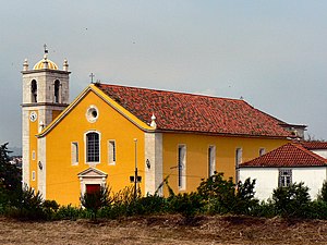
Igreja de Santa Maria (Loures)
Distance: Approx. 1026 meters
Latitude and longitude: 38.8328582,-9.1771195
Igreja de Santa Maria is a church in Portugal. It is classified as a National Monument.
Roman villa of Almoinhas
A Roman villa in the civil parish of Loures, Lisbon, Portugal
Distance: Approx. 886 meters
Latitude and longitude: 38.82534278,-9.16538889
The Roman villa of Almoinhas is a Roman villa in the civil parish of Loures, municipality of Loures, dating to the first to fifth century AD.

Roman villa of Frielas
Roman villa near Loures, Portugal
Distance: Approx. 1994 meters
Latitude and longitude: 38.8268747,-9.1438332
The Roman Villa of Frielas is located in the parish of Frielas in the municipality of Loures in the Lisbon District of Portugal. It fell under the territory of the Roman settlement of Olisipo, which covered a large area from Lisbon to the south to Torres Vedras in the north. It is believed to have been re-used in the medieval period during the Islamic occupation of Portugal.
Santo António dos Cavaleiros e Frielas
Civil parish in Lisbon, Portugal
Distance: Approx. 2154 meters
Latitude and longitude: 38.814,-9.167
Santo António dos Cavaleiros e Frielas is a civil parish in the municipality of Loures, Portugal. It was formed in 2013 by the merger of the former parishes Santo António dos Cavaleiros and Frielas. The population in 2011 was 28,052, in an area of 9.20 km2.
Ramada e Caneças
Civil parish in Lisbon, Portugal
Distance: Approx. 3951 meters
Latitude and longitude: 38.804,-9.191
Ramada e Caneças is a civil parish in the municipality of Odivelas, Portugal. It was formed in 2013 by the merger of the former parishes Ramada and Caneças. The population in 2011 was 32,581, in an area of 9.66 km2.
Loures (parish)
Civil parish in Lisbon, Portugal
Distance: Approx. 576 meters
Latitude and longitude: 38.829,-9.169
Loures is a civil parish in the municipality of Loures, Portugal. It is an urban parish, part of the city of Loures. The population in 2011 was 26,769, in an area of 32.82 km2.
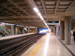
Odivelas Station
Metro station in Lisbon, Portugal
Distance: Approx. 4527 meters
Latitude and longitude: 38.79305556,-9.17277778
Odivelas station is the northern terminus on the Yellow Line of the Lisbon Metro in the Odivelas neighbourhood, north west of central Lisbon.
Weather in this IP's area
clear sky
27 Celsius
26 Celsius
23 Celsius
28 Celsius
1020 hPa
32 %
1020 hPa
1019 hPa
10000 meters
3.6 m/s
290 degree
07:30:52
19:22:44