Country:
 Great Britain
Region:
City:
Latitude and Longitude:
Time Zone:
Postal Code:
IP information under different IP Channel
ip-api
Country
Region
City
ASN
Time Zone
ISP
Blacklist
Proxy
Latitude
Longitude
Postal
Route
IPinfo
Country
Region
City
ASN
Time Zone
ISP
Blacklist
Proxy
Latitude
Longitude
Postal
Route
MaxMind
Country
Region
City
ASN
Time Zone
ISP
Blacklist
Proxy
Latitude
Longitude
Postal
Route
Luminati
Country
GBRegion
eng
City
bedford
ASN
Time Zone
Europe/London
ISP
TalkTalk
Latitude
Longitude
Postal
db-ip
Country
Region
City
ASN
Time Zone
ISP
Blacklist
Proxy
Latitude
Longitude
Postal
Route
ipdata
Country
Region
City
ASN
Time Zone
ISP
Blacklist
Proxy
Latitude
Longitude
Postal
Route
Popular places and events near this IP address
Cranfield University
British postgraduate public research university
Distance: Approx. 1397 meters
Latitude and longitude: 52.07333333,-0.62777778
Cranfield University is a British postgraduate-only public research university specialising in science, engineering, design, technology and management. Cranfield was founded as the College of Aeronautics (CoA) in 1946. Through the 1950s and 1960s, the development of aircraft research led to growth and diversification into other areas such as manufacturing and management, and in 1967, to the founding of the Cranfield School of Management.
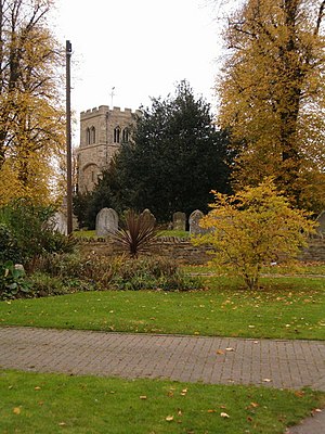
Cranfield
Village near Milton Keynes, England
Distance: Approx. 142 meters
Latitude and longitude: 52.0699,-0.6081
Cranfield is a village and civil parish in the west of Bedfordshire, England, situated between Bedford and Milton Keynes. It had a population of 4,909 in 2001. increasing to 5,369 at the 2011 census.

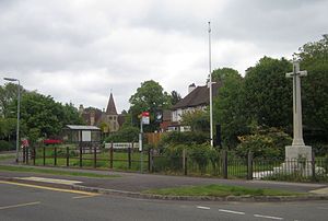
North East Milton Keynes (UK Parliament constituency)
Parliamentary constituency in the United Kingdom 1992-2010
Distance: Approx. 3033 meters
Latitude and longitude: 52.056,-0.648
North East Milton Keynes was a county constituency represented in the House of Commons of the Parliament of the United Kingdom from 1992 to 2010. It elected one member of parliament (MP) by the first past the post system of election.

Cranfield Airport
Airport in Cranfield
Distance: Approx. 666 meters
Latitude and longitude: 52.07222222,-0.61666667
Cranfield Airport (ICAO: EGTC) is an airfield just outside the village of Cranfield, in Bedfordshire, England. It is 7 NM (13 km; 8.1 mi) south-west of Bedford and 5.5 NM (10.2 km; 6.3 mi) east of Milton Keynes. It was originally a Second World War aerodrome, RAF Cranfield.

Hulcote and Salford
Civil parish in Central Bedfordshire, England
Distance: Approx. 3239 meters
Latitude and longitude: 52.043,-0.631
Hulcote and Salford is a civil parish in the district of Central Bedfordshire in the county of Bedfordshire. The parish was formed in 1933 by the union of the civil parishes of Hulcote and Salford. Until 1974 the parish was part of the Ampthill rural district.
Cranfield United F.C.
Association football club in England
Distance: Approx. 1326 meters
Latitude and longitude: 52.080244,-0.60400128
Cranfield United Football Club is a football club based in Cranfield, near Bedford, Bedfordshire, England. The club is affiliated to the Bedfordshire County Football Association. They are currently members of the Spartan South Midlands League Division One.

Cranfield School of Management
Business school in the UK
Distance: Approx. 1503 meters
Latitude and longitude: 52.074,-0.629
Cranfield School of Management, established in 1967, is a business school that is part of Cranfield University in Bedfordshire, United Kingdom.

Salford, Bedfordshire
Human settlement in England
Distance: Approx. 3361 meters
Latitude and longitude: 52.04415,-0.63738
Salford () is a village and former civil parish, now in the parish of Hulcote and Salford, in the Central Bedfordshire district, in the ceremonial county of Bedfordshire, England. It is located near the large new town of Milton Keynes and the M1 motorway. In 1931 the parish had a population of 133.
Church of St Nicholas, Hulcote, Bedfordshire
Distance: Approx. 3384 meters
Latitude and longitude: 52.0399,-0.6246
Church of St Nicholas is a Grade I listed church in Hulcote, Bedfordshire, England. It became a listed building on 23 January 1961.
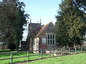
Church of St Peter & St Paul, Cranfield
Distance: Approx. 140 meters
Latitude and longitude: 52.068,-0.6071
Church of St Peter & St Paul is a Grade I listed church in Cranfield, Bedfordshire, England. It became a listed building on 23 January 1961.

Marston Thrift
Distance: Approx. 1813 meters
Latitude and longitude: 52.065,-0.583
Marston Thrift is a 37.4-hectare (92-acre) biological Site of Special Scientific Interest between Marston Moretaine and Cranfield in Bedfordshire. It was notified in 1984 under Section 28 of the Wildlife and Countryside Act 1981, and the local planning authority is Central Bedfordshire Council. It is also a Local Nature Reserve, which extends to a larger area of 55.8 hectares.
Cranfield Court
Distance: Approx. 857 meters
Latitude and longitude: 52.061,-0.6086
Cranfield Court was a country house in Cranfield, Bedfordshire, England. It belonged to the Harter family. The last house at the site was Elizabethan, and designed by Thomas Chambers Hine of Nottingham for Reverend G. G. Harter in 1862–4.
Weather in this IP's area
clear sky
20 Celsius
20 Celsius
20 Celsius
22 Celsius
1014 hPa
66 %
1014 hPa
1001 hPa
10000 meters
1.34 m/s
2.68 m/s
266 degree
05:16:47
21:00:51