Country:
 Iceland
Region:
City:
Latitude and Longitude:
Time Zone:
Postal Code:
IP information under different IP Channel
ip-api
Country
Region
City
ASN
Time Zone
ISP
Blacklist
Proxy
Latitude
Longitude
Postal
Route
IPinfo
Country
Region
City
ASN
Time Zone
ISP
Blacklist
Proxy
Latitude
Longitude
Postal
Route
MaxMind
Country
Region
City
ASN
Time Zone
ISP
Blacklist
Proxy
Latitude
Longitude
Postal
Route
Luminati
Country
ISRegion
1
City
reykjavik
ASN
Time Zone
Atlantic/Reykjavik
ISP
Ljosleidarinn ehf
Latitude
Longitude
Postal
db-ip
Country
Region
City
ASN
Time Zone
ISP
Blacklist
Proxy
Latitude
Longitude
Postal
Route
ipdata
Country
Region
City
ASN
Time Zone
ISP
Blacklist
Proxy
Latitude
Longitude
Postal
Route
Popular places and events near this IP address

Akranes
Municipality in Western Region, Iceland
Distance: Approx. 1164 meters
Latitude and longitude: 64.3158059,-22.09466
Akranes (Icelandic pronunciation: [ˈaːkraˌnɛːs] ) is a port town and municipality on the west coast of Iceland, around 50 km (31 mi) north of the capital Reykjavík. The area where Akranes is located was settled in the 9th century; however, it did not receive a municipal charter until 1942.
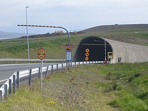
Hvalfjörður Tunnel
Tunnel in Iceland
Distance: Approx. 8360 meters
Latitude and longitude: 64.30972222,-21.90388889
The Hvalfjörður Tunnel (Icelandic: Hvalfjarðargöng pronounced [ˈkʰvalˌfjarðarˌkœyŋk] ) is a road tunnel under the Hvalfjörður fjord in Iceland and a part of Route 1. It is 5,770 meters (18,930 ft) long and reaches a depth of 165 meters (541 ft) below sea level. Opened on 11 July 1998, it shortens the distance from Reykjavík to the western and northern parts of the island by 45 kilometers (28 mi).

Akranesvöllur
Distance: Approx. 864 meters
Latitude and longitude: 64.31765556,-22.05975278
Akranesvöllur (Icelandic pronunciation: [ˈaːkraˌnɛsˌvœtlʏr̥]) (Known as ELKEM völlurinn for sponsorship purposes) is a football stadium in Akranes, Iceland. It is currently used for football matches. The stadium holds 5,550 and was built in 1935.
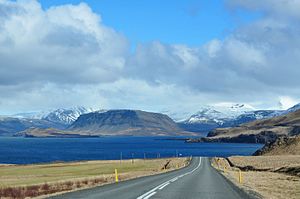
Hvalfjarðarsveit
Municipality in Vesturland, Iceland
Distance: Approx. 7783 meters
Latitude and longitude: 64.2959,-21.9251
Hvalfjarðarsveit (Icelandic pronunciation: [ˈkʰvalˌfjarðarˌsveiːt] ) is a municipality in Vesturland, Iceland. The municipality derives its name from the fjord Hvalfjörður, which forms its southern border. The municipality formed on 1 June 2006, by the union of the former municipalities of Hvalfjarðarstrandarhreppur, Innri-Akraneshreppur, Leirár- og Melahreppur and Skilmannahreppur.
Grundaskóli
School in Akranes, Iceland
Distance: Approx. 1037 meters
Latitude and longitude: 64.318677,-22.05465
Grundaskóli is one of two schools in the port town of Akranes, on the west coast of Iceland, established in 1981. The other school is Brekkubæjarskóli.
Akranes Folk Museum
Museum in Akranes, Iceland
Distance: Approx. 1458 meters
Latitude and longitude: 64.3199,-22.045
The Akranes Folk Museum (Icelandic: Byggðasafnið í Görðum Akranesi [ˈpɪɣðaˌsapnɪð i ˈkœrðʏm ˈaːkraˌnɛːsɪ]), formerly known as the Akranes Museum Centre (Safnasvæðið á Akranesi [ˈsapnaˌsvaiːðɪð au ˈaːkraˌnɛːsɪ]), consists of a folk museum, an exhibition hall and a few 19th century buildings and boats in Garðar, Akranes, Iceland. The museum houses a few exhibitions, as well as a large open-air museum, which consists mainly of houses and boats, including the old Garðar house and the 86-tonne ketch Sigurfari (Kútter Sigurfari). The main purpose of the Akranes Folk Museum is to collect, register, preserve, research and display artefacts and other objects of cultural and historical value for the Akranes area and Iceland.
Weather in this IP's area
light rain
11 Celsius
11 Celsius
11 Celsius
11 Celsius
1002 hPa
87 %
1002 hPa
1001 hPa
10000 meters
6.49 m/s
9.95 m/s
107 degree
100 %
04:21:39
22:47:42