Country:
 Romania
Region:
City:
Latitude and Longitude:
Time Zone:
Postal Code:
IP information under different IP Channel
ip-api
Country
Region
City
ASN
Time Zone
ISP
Blacklist
Proxy
Latitude
Longitude
Postal
Route
IPinfo
Country
Region
City
ASN
Time Zone
ISP
Blacklist
Proxy
Latitude
Longitude
Postal
Route
MaxMind
Country
Region
City
ASN
Time Zone
ISP
Blacklist
Proxy
Latitude
Longitude
Postal
Route
Luminati
Country
RORegion
ph
City
ploiesti
ASN
Time Zone
Europe/Bucharest
ISP
Orange Romania S.A.
Latitude
Longitude
Postal
db-ip
Country
Region
City
ASN
Time Zone
ISP
Blacklist
Proxy
Latitude
Longitude
Postal
Route
ipdata
Country
Region
City
ASN
Time Zone
ISP
Blacklist
Proxy
Latitude
Longitude
Postal
Route
Popular places and events near this IP address
Colți
Commune in Buzău, Romania
Distance: Approx. 9592 meters
Latitude and longitude: 45.38333333,26.4
Colți (Romanian pronunciation: [kolt͡sʲ]) is a commune in Buzău County, Muntenia, Romania, located in the Pătârlagele hollow, at the curvature of the Carpathian mountains, 13 km away from the town of Pătârlagele. It is composed of four villages: Aluniș, Colți, Colții de Jos and Muscelu Cărămănești.
Lopătari
Commune in Buzău, Romania
Distance: Approx. 8565 meters
Latitude and longitude: 45.48333333,26.58333333
Lopătari is a commune in Buzău County, Muntenia, Romania. It is composed of eleven villages: Brebu, Fundata, Lopătari, Luncile, Pestrițu, Plaiu Nucului, Ploștina, Potecu, Săreni, Terca and Vârteju.

Gura Teghii
Commune in Buzău, Romania
Distance: Approx. 8565 meters
Latitude and longitude: 45.48333333,26.41666667
Gura Teghii is a commune in Buzău County, Muntenia, Romania, located in the north-westernmost part of the county in its mountain region, near the limit of Covasna and Vrancea counties, in the Curvature Carpathians. Gura Teghii made up of seven mountain villages (Furtunești, Gura Teghii, Nemertea, Păltiniș, Secuiu, Vadu Oii, Varlaam) on the valley of the river Bâsca Roziliei and of its tributaries, Bâsca Mică and Bâsca Mare. Mentioned in documents starting with the 16th century, these settlements were founded by the yeomen from Sibiciu area, who had owned those lands before they were taken over by wealthy boyar landowners.

Bozioru
Commune in Buzău, Romania
Distance: Approx. 5713 meters
Latitude and longitude: 45.38333333,26.48333333
Bozioru is a commune in Buzău County, Muntenia, Romania. It is composed of ten villages: Bozioru, Buduile, Fișici, Găvanele, Gresia, Izvoarele, Nucu, Scăeni, Ulmet and Văvălucile.

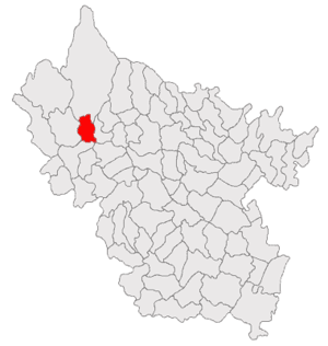
Brăești, Buzău
Commune in Buzău, Romania
Distance: Approx. 4 meters
Latitude and longitude: 45.43333333,26.5
Brăești is a commune in Buzău County, Muntenia, Romania. It is composed of seven villages: Brăești, Brătilești, Goidești, Ivănețu, Pinu, Pârscovelu and Ruginoasa. The commune is traversed by the river Bălăneasa.
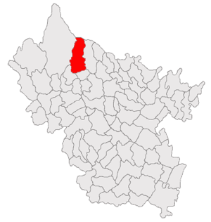
Cănești
Commune in Buzău, Romania
Distance: Approx. 8649 meters
Latitude and longitude: 45.4,26.6
Cănești is a commune in Buzău County, Muntenia, Romania. It's composed of six villages: Cănești, Gonțești, Negoșina, Păcuri, Șuchea and Valea Verzei.

Chiliile
Commune in Buzău, Romania
Distance: Approx. 6769 meters
Latitude and longitude: 45.45,26.58333333
Chiliile is a commune in Buzău County, Muntenia, Romania. It is composed of seven villages: Budești, Chiliile, Crevelești, Ghiocari, Glodu-Petcari, Poiana Pletari and Trestioara.

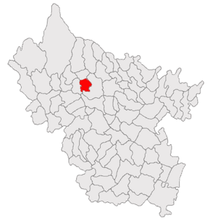
Odăile
Commune in Buzău, Romania
Distance: Approx. 5660 meters
Latitude and longitude: 45.39361111,26.54527778
Odăile is a commune in Buzău County, Muntenia, Romania. It is composed of ten villages: Capu Satului, Corneanu, Gorâni, Lacu, Odăile, Piatra Albă, Posobești, Scoroșești, Valea Fântânei and Valea Ștefanului.
1986 Vrancea earthquake
Distance: Approx. 7425 meters
Latitude and longitude: 45.5,26.5
Striking central Romania on August 30 at 21:28 UTC, the 1986 Vrancea earthquake killed more than 150 people, injured over 500, and damaged over 50,000 homes. The second largest earthquake in the area since the modernization of earthquake monitoring devices, it was felt north to Poland and south to Italy and Greece. The death toll makes it the second deadliest earthquake to occur in 1986 worldwide, after major seism of San Salvador that took the lives of almost 1,500 people.
Weather in this IP's area
clear sky
17 Celsius
17 Celsius
17 Celsius
17 Celsius
1021 hPa
64 %
1021 hPa
958 hPa
10000 meters
2 m/s
1.66 m/s
334 degree
05:53:40
20:47:05