Country:
 Romania
Region:
City:
Latitude and Longitude:
Time Zone:
Postal Code:
IP information under different IP Channel
ip-api
Country
Region
City
ASN
Time Zone
ISP
Blacklist
Proxy
Latitude
Longitude
Postal
Route
IPinfo
Country
Region
City
ASN
Time Zone
ISP
Blacklist
Proxy
Latitude
Longitude
Postal
Route
MaxMind
Country
Region
City
ASN
Time Zone
ISP
Blacklist
Proxy
Latitude
Longitude
Postal
Route
Luminati
Country
RORegion
bt
City
botosani
ASN
Time Zone
Europe/Bucharest
ISP
Orange Romania S.A.
Latitude
Longitude
Postal
db-ip
Country
Region
City
ASN
Time Zone
ISP
Blacklist
Proxy
Latitude
Longitude
Postal
Route
ipdata
Country
Region
City
ASN
Time Zone
ISP
Blacklist
Proxy
Latitude
Longitude
Postal
Route
Popular places and events near this IP address
Slobozia
Municipality in Ialomița, Romania
Distance: Approx. 3637 meters
Latitude and longitude: 44.56388889,27.36611111
Slobozia (Romanian pronunciation: [sloboˈzi.a]) is the capital city of Ialomița County, Muntenia, Romania, with a population of 41,550 in 2021.

Amara, Romania
Town in Ialomița, Romania
Distance: Approx. 9940 meters
Latitude and longitude: 44.62,27.32
Amara is a town in Ialomița County, Muntenia, Romania. It is located in Bărăgan on the shores of Lake Amara, at 7 kilometres (4.3 miles) north of the county capital, Slobozia. Amara was elevated to town status in 2004.
Cosâmbești
Commune in Ialomița, Romania
Distance: Approx. 7583 meters
Latitude and longitude: 44.56666667,27.43333333
Cosâmbești is a commune located in Ialomița County, Muntenia, Romania. It is composed of two villages, Cosâmbești and Gimbășani. It also included Mărculești village until 2005, when this was split off to form Mărculești Commune.
Ciulnița
Commune in Ialomița, Romania
Distance: Approx. 4 meters
Latitude and longitude: 44.53333333,27.35
Ciulnița is a commune located in Ialomița County, Muntenia, Romania. It is composed of four villages: Ciulnița, Ion Ghica, Ivănești, and Poiana. The commune is located in the south-central part of the county, on the border with Călărași County.
Perieți, Ialomița
Commune in Ialomița, Romania
Distance: Approx. 9387 meters
Latitude and longitude: 44.56583333,27.24083333
Perieți is a commune located in Ialomița County, Muntenia, Romania. It is composed of five villages: Fundata, Misleanu, Păltinișu, Perieți and Stejaru.

Lake Amara
Distance: Approx. 8370 meters
Latitude and longitude: 44.608,27.338
Lake Amara (Romanian: Lacul Amara) is a saltwater fluvial liman lake located on the Slobozia - Buzău road near Amara in Ialomița County, Romania. The lake has a surface area of 132 ha (0.51 sq mi), a water volume of 2,600,000 m3 (0.00062 cu mi), a length of 4 km (2.5 mi) and a width between 200 m (660 ft) and 800 m (2,600 ft) while the maximum depth reaches 3 m (9.8 ft). The lake is situated in a depression having no links to the Ialomița River.

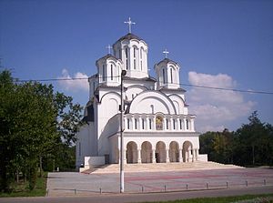
Sfinții Voievozi Monastery
Distance: Approx. 3815 meters
Latitude and longitude: 44.5618,27.3767
The Sfinții Voievozi Monastery (Romanian: Mănăstirea Sfinții Voievozi) is a monastery in Slobozia, Ialomița County, Romania. It dates to the 17th century.
Mihai Viteazul National College (Slobozia)
Distance: Approx. 3456 meters
Latitude and longitude: 44.5642,27.3542
Mihai Viteazul National College (Romanian: Colegiul Național Mihai Viteazul) is a high school located at 10 Unirii Boulevard, Slobozia, Romania. The school was founded in 1952, in the early years of the communist regime, and was co-educational from the beginning. Initially covering grades 1 through 8, it had the full eleven grades of the period within two years.
Weather in this IP's area
clear sky
25 Celsius
25 Celsius
25 Celsius
25 Celsius
1015 hPa
46 %
1015 hPa
1009 hPa
10000 meters
3.24 m/s
4.7 m/s
205 degree
05:54:05
20:39:50