Country:
 Romania
Region:
City:
Latitude and Longitude:
Time Zone:
Postal Code:
IP information under different IP Channel
ip-api
Country
Region
City
ASN
Time Zone
ISP
Blacklist
Proxy
Latitude
Longitude
Postal
Route
IPinfo
Country
Region
City
ASN
Time Zone
ISP
Blacklist
Proxy
Latitude
Longitude
Postal
Route
MaxMind
Country
Region
City
ASN
Time Zone
ISP
Blacklist
Proxy
Latitude
Longitude
Postal
Route
Luminati
Country
RORegion
bt
City
botosani
ASN
Time Zone
Europe/Bucharest
ISP
Orange Romania S.A.
Latitude
Longitude
Postal
db-ip
Country
Region
City
ASN
Time Zone
ISP
Blacklist
Proxy
Latitude
Longitude
Postal
Route
ipdata
Country
Region
City
ASN
Time Zone
ISP
Blacklist
Proxy
Latitude
Longitude
Postal
Route
Popular places and events near this IP address
Șercăița
River in Brașov County, Romania
Distance: Approx. 6268 meters
Latitude and longitude: 45.7799,25.1589
The Șercăița is a left tributary of the river Șercaia in Romania. It flows into the Șercaia between Șinca and Vad. Its length is 19 km (12 mi) and its basin size is 65 km2 (25 sq mi).
Veneția
River in Brașov County, Romania
Distance: Approx. 7475 meters
Latitude and longitude: 45.8827,25.1986
The Veneția (Romanian pronunciation: [veneˈt͡si.a]) is a left tributary of the river Olt in Romania. It flows into the Olt near Veneția de Jos. Its length is 19 km (12 mi) and its basin size is 49 km2 (19 sq mi).
Mândra (Olt)
River in Brașov County, Romania
Distance: Approx. 7568 meters
Latitude and longitude: 45.8384,25.036
The Mândra (also: Iaz) is a left tributary of the river Olt in Romania. It flows into the Olt near the village Mândra. Its length is 23 km (14 mi) and its basin size is 29 km2 (11 sq mi).

Sebeș (Brașov)
River in Brașov County, Romania
Distance: Approx. 8729 meters
Latitude and longitude: 45.8385,25.021
The Sebeș (Hungarian: Sebes-patak) is a left tributary of the river Olt in Romania. It discharges into the Olt east of Făgăraș. The source of the Sebeș is in the Făgăraș Mountains.
Părău (river)
River in Brașov County, Romania
Distance: Approx. 4745 meters
Latitude and longitude: 45.8655,25.1734
The Părău is a left tributary of the river Olt in Romania. It flows into the Olt near the village Părău. The upper reach is also known as Perșani.
Ticuș
River in Brașov County, Romania
Distance: Approx. 9520 meters
Latitude and longitude: 45.907,25.1956
The Ticuș is a right tributary of the river Olt in Romania. It discharges into the Olt in Ticușu Nou. Its length is 19 km (12 mi) and its basin size is 75 km2 (29 sq mi).
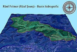
Felmer
River in Brașov County, Romania
Distance: Approx. 4081 meters
Latitude and longitude: 45.8646,25.1059
The Felmer or Șoarș is a right tributary of the river Olt in Romania. It discharges into the Olt in Hălmeag. Its length is 26 km (16 mi) and its basin size is 103 km2 (40 sq mi).

Mândra
Commune in Brașov, Romania
Distance: Approx. 6880 meters
Latitude and longitude: 45.822,25.0461
Mândra (German: Kladendorf; Hungarian: Mundra) is a commune in Brașov County, Transylvania, Romania. It is composed of five villages: Ileni (Illény), Mândra, Râușor (Reusor), Șona (Schönen; Sona), and Toderița (Todorica). The commune is located in the west-central part of the county, close to the geographical center of Romania.
Părău
Commune in Brașov, Romania
Distance: Approx. 4302 meters
Latitude and longitude: 45.85,25.18333333
Părău (German: Mikesdorf-Berau; Hungarian: Páró) is a commune in Brașov County, Transylvania, Romania. It is composed of four villages: Grid, Părău, Veneția de Jos (Untervenitze; Alsóvenice), and Veneția de Sus (Felsővenice). The commune is situated in the center of the county, in the historic Țara Făgărașului region.

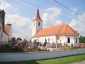
Șercaia
Commune in Brașov, Romania
Distance: Approx. 5 meters
Latitude and longitude: 45.83333333,25.13333333
Șercaia (German: Schirkanyen; Hungarian: Sárkány; Turkish: Saruhan) is a commune in Brașov County, Transylvania, Romania. It is composed of three villages: Hălmeag (Halmagen; Halmágy; Halmaç), Șercaia and Vad (Waadt, Waden; Vád). The Hungarian name means "dragon".
Castra of Șinca Veche
Fort in the Roman province of Dacia
Distance: Approx. 9628 meters
Latitude and longitude: 45.75,25.16666667
It was a fort in the Roman province of Dacia.
Weather in this IP's area
clear sky
21 Celsius
21 Celsius
21 Celsius
21 Celsius
1020 hPa
52 %
1020 hPa
970 hPa
10000 meters
1.17 m/s
1.47 m/s
81 degree
05:57:53
20:53:48