Country:
 Netherlands
Region:
City:
Latitude and Longitude:
Time Zone:
Postal Code:
IP information under different IP Channel
ip-api
Country
Region
City
ASN
Time Zone
ISP
Blacklist
Proxy
Latitude
Longitude
Postal
Route
IPinfo
Country
Region
City
ASN
Time Zone
ISP
Blacklist
Proxy
Latitude
Longitude
Postal
Route
MaxMind
Country
Region
City
ASN
Time Zone
ISP
Blacklist
Proxy
Latitude
Longitude
Postal
Route
Luminati
Country
NLASN
Time Zone
Europe/Amsterdam
ISP
VANCIS Vancis Advanced ICT Services
Latitude
Longitude
Postal
db-ip
Country
Region
City
ASN
Time Zone
ISP
Blacklist
Proxy
Latitude
Longitude
Postal
Route
ipdata
Country
Region
City
ASN
Time Zone
ISP
Blacklist
Proxy
Latitude
Longitude
Postal
Route
Popular places and events near this IP address

Grote Kerk, Haarlem
Church in Haarlem, Netherlands
Distance: Approx. 88 meters
Latitude and longitude: 52.381241,4.637871
The Grote Kerk or St.-Bavokerk is a Reformed Protestant church and former Catholic cathedral located on the central market square (Grote Markt) in the Dutch city of Haarlem. Another Haarlem church called the Cathedral of Saint Bavo now serves as the main cathedral for the Roman Catholic Diocese of Haarlem-Amsterdam.

Haarlem City Hall
Seat of government in Haarlem, Netherlands
Distance: Approx. 156 meters
Latitude and longitude: 52.38138889,4.63472222
The City Hall in Haarlem is the seat of the city's government. It was built in the 14th century replacing the Count's castle.

Vleeshal
Former meat hall in Haarlem
Distance: Approx. 28 meters
Latitude and longitude: 52.38083333,4.63638889
The Vleeshal is a historical building dating from 1603 on the Grote Markt in Haarlem, the Netherlands.

Hoofdwacht, Haarlem
Building in Haarlem, Netherlands
Distance: Approx. 99 meters
Latitude and longitude: 52.38166667,4.63648889
The Hoofdwacht (Head Watch, or "Civic guard headquarters") is a historically important rijksmonument. It was built in the 13th century and it is considered the oldest building in Haarlem, Netherlands. It has served as a printshop for Coornhert, as a temporary council meeting location across from City Hall and even as a jail.

Hofje In den Groenen Tuin
Hofje in Haarlem, Netherlands
Distance: Approx. 59 meters
Latitude and longitude: 52.38027778,4.63694444
The Hofje in den Groenen Tuin is a hofje in Haarlem, Netherlands.

Frans Hals Museum - Hal
Art museum in Haarlem, Netherlands
Distance: Approx. 47 meters
Latitude and longitude: 52.38083333,4.63611111
Frans Hals Museum - Hal (until March 29, 2018: De Hallen Haarlem) is one of the two locations of the Frans Hals Museum, located on the Grote Markt, Haarlem, Netherlands, where modern and contemporary art is on display in alternating presentations. The emphasis is on contemporary photograph and video presentations, with the focus on Man and society. The museum consists of three different buildings, the Vleeshal (Flesher's hall) on the east side and the Verweyhal (named for Kees Verwey) on the west side are two large "halls" sandwiching the small entrance building.
Grote Markt (Haarlem)
Distance: Approx. 88 meters
Latitude and longitude: 52.38136667,4.63590556
The Grote Markt (Dutch: [ˌɣroːtə ˈmɑr(ə)kt] ; "Big Market") is the central market square of Haarlem, Netherlands. According to the 1911 Encyclopædia Britannica; In the great market place in the centre of the city are gathered together the larger number of the most interesting buildings, including the quaint old Fleshers' Hall, built by Lieven de Key in 1603, and now containing the archives; the town hall; the old Stadsdoelen, where the burgesses met in arms; the Groote Kerk, or Great Church; and the statue erected in 1856 to Laurens Janszoon Koster, the printer. The Great Church, dedicated to St Bavo, with a lofty tower (255 ft.), is one of the most famous in Holland, and dates from the end of the 15th and the beginning of the 16th centuries.
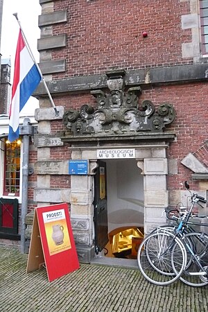
Archeologisch Museum Haarlem
Distance: Approx. 47 meters
Latitude and longitude: 52.38083333,4.63611111
The Archeologisch Museum Haarlem is a museum in the cellar of the Vleeshal on the Grote Markt in Haarlem, the Netherlands, dedicated to promoting interest and conserving the archeological heritage of Kennemerland.
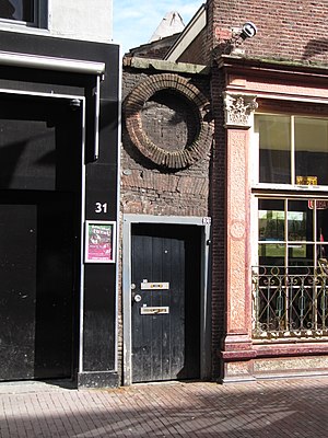
Doopsgezinde kerk, Haarlem
Mennonite church in the Netherlands
Distance: Approx. 154 meters
Latitude and longitude: 52.38,4.63494444
The Doopsgezinde kerk is a historical hidden Mennonite church dating from the 17th century between the Grote Houtstraat, Peuzelaarsteeg and the Frankestraat in Haarlem, Netherlands.
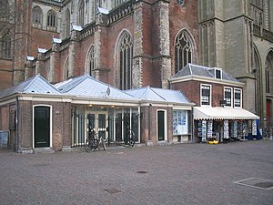
De Vishal
Distance: Approx. 66 meters
Latitude and longitude: 52.38138889,4.63666667
De Vishal is a historical building dating from 1769 on the Grote Markt in Haarlem, the Netherlands. It is built up against the St. Bavochurch.
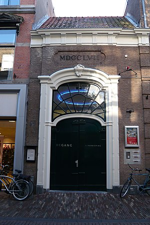
Smedestraat 33 (Haarlem)
Doorway in Haarlem, Netherlands
Distance: Approx. 161 meters
Latitude and longitude: 52.38222222,4.63638889
Smedestraat 33 (Dutch: Smedestraat 33) is the address of a doorway in Haarlem. The brickwork of the doorway, including a round false window, is from the second half of the 17th century, and has been declared one of the national monuments of The Netherlands. This brick doorway only recently acquired the lock on the door and was originally an open access gateway to an alley that separated two houses and joined up with the small public garden called the Wijngaardtuin.

Verweyhal
Distance: Approx. 47 meters
Latitude and longitude: 52.38083333,4.63611111
The Verweyhal is an exhibition space next to the Vleeshal on the Grote Markt, Haarlem. The Verweyhal was built in the 19th century as a gentlemen's society of the former drama society, later a cultural social club, Trou moet Blycken. In the second half of the 19th century the earlier building of the drama society, which was on the same spot, was too small.
Weather in this IP's area
few clouds
23 Celsius
23 Celsius
22 Celsius
24 Celsius
1013 hPa
52 %
1013 hPa
1013 hPa
10000 meters
2.57 m/s
220 degree
20 %
05:54:26
21:41:14