Country:
 Ecuador
Region:
City:
Latitude and Longitude:
Time Zone:
Postal Code:
IP information under different IP Channel
ip-api
Country
Region
City
ASN
Time Zone
ISP
Blacklist
Proxy
Latitude
Longitude
Postal
Route
IPinfo
Country
Region
City
ASN
Time Zone
ISP
Blacklist
Proxy
Latitude
Longitude
Postal
Route
MaxMind
Country
Region
City
ASN
Time Zone
ISP
Blacklist
Proxy
Latitude
Longitude
Postal
Route
Luminati
Country
ECRegion
p
City
quito
ASN
Time Zone
America/Guayaquil
ISP
GSL Networks Pty LTD
Latitude
Longitude
Postal
db-ip
Country
Region
City
ASN
Time Zone
ISP
Blacklist
Proxy
Latitude
Longitude
Postal
Route
ipdata
Country
Region
City
ASN
Time Zone
ISP
Blacklist
Proxy
Latitude
Longitude
Postal
Route
Popular places and events near this IP address

El Panecillo
Mountain in Quito Canton, Ecuador
Distance: Approx. 712 meters
Latitude and longitude: -0.22861111,-78.51861111
El Panecillo (from Spanish panecillo small piece of bread, diminutive of pan bread) is a 200-metre-high hill of volcanic-origin, with loess soil, located between southern and central Quito. Its peak is at an elevation of 3,016 metres (9,895 ft) above sea level. The original name used by the aboriginal inhabitants of Quito was Yavirac.

Battle of Pichincha
Battle of the Ecuadorian War of Independence
Distance: Approx. 1221 meters
Latitude and longitude: -0.21908889,-78.52726389
The Battle of Pichincha took place on 24 May 1822, on the slopes of the Pichincha volcano, 3,500 meters above sea-level, right next to the city of Quito, in modern Ecuador. The encounter, fought in the context of the Spanish American wars of independence, pitted a Patriot army under General Antonio José de Sucre against a Royalist army commanded by Field Marshal Melchor Aymerich. The defeat of the Royalist forces loyal to Spain brought about the liberation of Quito, and secured the independence of the provinces belonging to the Real Audiencia de Quito, or Presidencia de Quito, the Spanish colonial administrative jurisdiction from which the Republic of Ecuador would eventually emerge.

Alfaro, Quito
Distance: Approx. 1160 meters
Latitude and longitude: -0.23297222,-78.51497222
Alfaro is an electoral urban parish or district of Quito, Ecuador. The parish was established as a result of the October 2004 political elections, when the city was divided into 19 electoral urban parishes.

La Magdalena, Quito
Ecuadorian electoral district
Distance: Approx. 1539 meters
Latitude and longitude: -0.243,-78.529
La Magdalena is an electoral parish (parroquia electorale urban) or district of Quito, the capital city of Ecuador. The parish was established as a result of the October 2004 political elections when the city was divided into 19 urban electoral parishes.

Basilica and Convent of San Francisco, Quito
Distance: Approx. 1485 meters
Latitude and longitude: -0.22027778,-78.51555556
The Basilica and Convent of San Francisco (Spanish: Iglesia y Convento de San Francisco), commonly known as el San Francisco, is a Catholic basilica that stands in the middle of the historic center of Quito, in front of the square of the same name. It is the oldest and most significant religious site in Ecuador. The structure is the largest architectural complex within the historic centers of all of South America, and for this reason it was known as "El Escorial of the New World".

Ecuador National Museum of Medicine
Distance: Approx. 1266 meters
Latitude and longitude: -0.2234,-78.5155
The Ecuador National Museum of Medicine is located in Quito, Ecuador.

Casa del Alabado Museum of Pre-Columbian Art
Museum in Quito, Ecuador
Distance: Approx. 1388 meters
Latitude and longitude: -0.221258,-78.515822
Casa del Alabado is a Pre-Columbian art museum in Quito, Ecuador. The museum is located in a colonial house built in the 17th century during the Spanish Colony. It houses a collection of over 5,000 archaeological pieces, 500 of which are on permanent display.

Plaza de San Francisco, Quito
Distance: Approx. 1504 meters
Latitude and longitude: -0.22072222,-78.51488889
The Plaza de San Francisco (“Saint Francis Square”) is a major public square in the Historic Center of Quito, Ecuador, upon which faces La Iglesia y Monasterio de San Francisco (the Church and Convent of St. Francis) from which it takes its name.

City Museum (Quito)
History museum in Quito, Ecuador
Distance: Approx. 1333 meters
Latitude and longitude: -0.22305556,-78.515
The City Museum (Museo de la Ciudad) is a museum in the colonial center of Quito, Ecuador. It is located on Garcia Moreno Street, between Morales and Rocafuerte. The museum was founded in 1998 and occupies the buildings of what once was the San Juan de Dios Hospital.
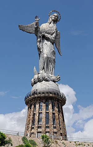
Virgin of El Panecillo
Sculpture in Quito, Ecuador
Distance: Approx. 709 meters
Latitude and longitude: -0.22888,-78.5186
The Virgin of El Panecillo (in Spanish: Virgen del Panecillo), also known as the Virgin of Quito from the sculpture of the same name, is a monument in Quito, Ecuador. It is located on the top of the hill of El Panecillo, a loaf-shaped hill in the heart of the city and serves as a backdrop to the historic center of Quito. With a total height of 135 feet (41 meters) including the base, it is the highest statue in Ecuador and one of the highest in South America (taller than the Christ the Redeemer statue in the Brazilian city of Rio de Janeiro).

National Ecuadorian Exposition
Distance: Approx. 1409 meters
Latitude and longitude: -0.231,-78.5123
The National Ecuadorian Exposition was a world's fair held in Quito in 1909 to mark 100 years since the start of the campaign for Ecuadorian independence from Spain. The Palace of the Exhibition was formally opened on 10 August 1909 to mark 100 years since the "First Cry for Independence". The fair opened on 8 September.
La Magdalena metro station
Quito metro station
Distance: Approx. 905 meters
Latitude and longitude: -0.23791667,-78.52536111
La Magdalena is a Quito Metro station. It was officially opened on 21 December 2022 as part of the inaugural section of the system between Quitumbe and El Labrador. The revenue service started on 2 May 2023 and stopped on 11 May 2023.
Weather in this IP's area
clear sky
8 Celsius
6 Celsius
8 Celsius
8 Celsius
1019 hPa
68 %
1019 hPa
723 hPa
10000 meters
2.5 m/s
3.49 m/s
119 degree
6 %
06:17:15
18:23:39