Country:
 Bolivia
Region:
City:
Latitude and Longitude:
Time Zone:
Postal Code:
IP information under different IP Channel
ip-api
Country
Region
City
ASN
Time Zone
ISP
Blacklist
Proxy
Latitude
Longitude
Postal
Route
IPinfo
Country
Region
City
ASN
Time Zone
ISP
Blacklist
Proxy
Latitude
Longitude
Postal
Route
MaxMind
Country
Region
City
ASN
Time Zone
ISP
Blacklist
Proxy
Latitude
Longitude
Postal
Route
Luminati
Country
BORegion
l
City
lapaz
ASN
Time Zone
America/La_Paz
ISP
GSL Networks Pty LTD
Latitude
Longitude
Postal
db-ip
Country
Region
City
ASN
Time Zone
ISP
Blacklist
Proxy
Latitude
Longitude
Postal
Route
ipdata
Country
Region
City
ASN
Time Zone
ISP
Blacklist
Proxy
Latitude
Longitude
Postal
Route
Popular places and events near this IP address

El Alto
City and municipality in La Paz Department, Bolivia
Distance: Approx. 1521 meters
Latitude and longitude: -16.50472222,-68.16333333
El Alto (Spanish for "The Heights") is the second-largest city in Bolivia, located adjacent to La Paz in Pedro Domingo Murillo Province on the Altiplano highlands. El Alto is today one of Bolivia's fastest-growing urban centers, with an estimated population of 943,558 in 2020. It is also the highest major city in the world, with an average elevation of 4,000 m (13,123 ft).

Estadio Libertador Simón Bolívar
Distance: Approx. 1693 meters
Latitude and longitude: -16.5125,-68.14111111
Estadio Libertador Simón Bolívar is a multi-use stadium in the Tembladerani neighborhood of the city of La Paz, Bolivia. It is most often used for football matches, on club level by Club Bolívar. The stadium has a capacity of 5,000 people and was founded on 9 February 1968.

Central Bank of Bolivia
Monetary Authority of Bolivia
Distance: Approx. 1687 meters
Latitude and longitude: -16.49722222,-68.13444444
The Central Bank of Bolivia (Spanish: Banco Central de Bolivia) is the central bank of Bolivia, responsible for monetary policy and the issuance of banknotes. The current president of the BCB is Pablo Ramos Sánchez.

San Pedro prison
Prison in La Paz, Bolivia
Distance: Approx. 1697 meters
Latitude and longitude: -16.50305556,-68.13444444
San Pedro prison or El penal de San Pedro (Saint Peter's Prison) is the largest prison in La Paz, Bolivia and is renowned for being a society within itself. Significantly different from most correctional facilities, inmates at San Pedro have jobs inside the community, buy or rent their accommodation, and often live with their families. Prior to 2009, an illegal tourist trade flourished at the prison, with some tourists staying overnight at a hotel inside; the sale of cocaine base to visiting tourists gave some prisoners a significant income.
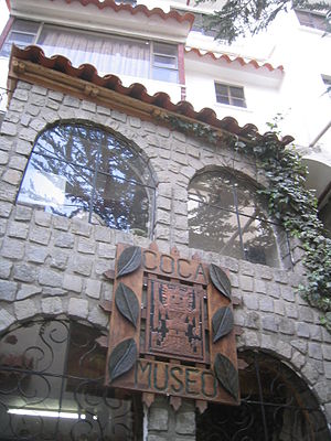
Coca Museum
Museum in La Paz, Bolivia
Distance: Approx. 1283 meters
Latitude and longitude: -16.4977,-68.1382
The Coca Museum (in Spanish, Museo de la Coca) covers the history of the coca plant from the Andean region and related drug cocaine. It is associated with the International Coca Research Institute (ICORI) in La Paz, the government seat in Bolivia. A travelling version of the museum is available.

The Witches' Market
Distance: Approx. 107 meters
Latitude and longitude: -16.5,-68.149
The Witches' Market, also known as El Mercado de las Brujas and La Hechiceria, is a popular tourist attraction located in Cerro Cumbre, a mountain clearing in La Paz, Bolivia. The market is run by local witch doctors known as yatiri, who sell potions, dried frogs, medicinal plants like retama, and armadillos used in Bolivian rituals. The yatiri can be easily identified by their black hats and coca pouches containing amulets, talismans and powders that promise luck, beauty and fertility.

Plaza San Francisco
Plaza in La Paz, Bolivia
Distance: Approx. 1447 meters
Latitude and longitude: -16.4959,-68.1371
Plaza San Francisco is a major urban plaza in the city of La Paz, Bolivia, and a frequent location for political gatherings and protests. It is located in front of the Basilica of San Francisco (from which it takes its name) as well as the Lanza Market and the headquarters of the La Paz Factory Worker's Departmental Union Federation. The plaza was enlarged to 6,163 square meters in 2011.
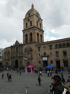
Basilica of San Francisco, La Paz
Church in La Paz, Bolivia
Distance: Approx. 1407 meters
Latitude and longitude: -16.4965,-68.1373
The Basilica of San Francisco in the city of La Paz, Bolivia, is a Catholic church under the advocation of Francis of Assisi. It is located in the center of the city, in the square that bears its name, Plaza San Francisco. The building was built between 1743 and 1772 but its tower was built in the end of the 19th century.

Museo San Francisco Cultural Center
Cultural institution located in La Paz city, Bolivia
Distance: Approx. 1462 meters
Latitude and longitude: -16.49622583,-68.13685278
The Museo San Francisco Cultural Center is a cultural institution located in La Paz city, Bolivia. It was established with the aim of preserving and conserving the arts and memories related to events and historic moments of the city of La Paz in Bolivia, because the history of the convent and the Basilica of San Francisco that houses the museum is closely related to the history of this city.
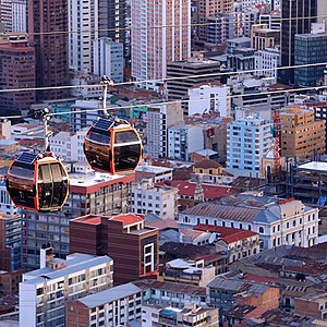
Mi Teleférico
Cable car system in La Paz and El Alto, Bolivia
Distance: Approx. 11 meters
Latitude and longitude: -16.5,-68.15
Mi Teleférico (Spanish pronunciation: [mi teleˈfeɾiko], English: My Cable Car), also known as Teleférico La Paz–El Alto (La Paz–El Alto Cable Car), is an aerial cable car urban transit system serving the La Paz–El Alto metropolitan area in Bolivia. As of October 2019, the system consists of 26 stations (36 if transfer stations are counted separately per line) along ten lines: Red, Yellow, Green, Blue, Orange, White, Sky Blue, Purple, Brown, and Silver. Further lines and extensions are in planning or construction.

General Cemetery of La Paz
Cemetery in La Paz, Bolivia
Distance: Approx. 374 meters
Latitude and longitude: -16.49694444,-68.15166667
The General Cemetery of La Paz (Cementerio General de La Paz) is a public cemetery located in the Max Paredes macro-district, in the northwest area of La Paz, Bolivia, and has an area of 92,000 square meters.

La Llamita Cemetery
Distance: Approx. 374 meters
Latitude and longitude: -16.49694444,-68.15166667
The La Llamita Cemetery (Cementerio La Llamita) is a cemetery located in the Periférica macro district, in the Agua de la Vida Norte area of northern La Paz, Bolivia. It is considered clandestine because it is not under the custody of the municipal government of that city. In 2017, a revitalization and recovery project was planned.
Weather in this IP's area
fog
6 Celsius
4 Celsius
2 Celsius
6 Celsius
1022 hPa
74 %
1022 hPa
659 hPa
8000 meters
3.09 m/s
60 degree
20 %
06:58:10
18:19:44