Country:
 USA
USARegion:
City:
Latitude and Longitude:
Time Zone:
Postal Code:
IP information under different IP Channel
ip-api
Country
Region
City
ASN
Time Zone
ISP
Blacklist
Proxy
Latitude
Longitude
Postal
Route
IPinfo
Country
Region
City
ASN
Time Zone
ISP
Blacklist
Proxy
Latitude
Longitude
Postal
Route
MaxMind
Country
Region
City
ASN
Time Zone
ISP
Blacklist
Proxy
Latitude
Longitude
Postal
Route
Luminati
Country
USRegion
nj
City
trenton
ASN
Time Zone
America/New_York
ISP
Datacamp Limited
Latitude
Longitude
Postal
db-ip
Country
Region
City
ASN
Time Zone
ISP
Blacklist
Proxy
Latitude
Longitude
Postal
Route
ipdata
Country
Region
City
ASN
Time Zone
ISP
Blacklist
Proxy
Latitude
Longitude
Postal
Route
Popular places and events near this IP address
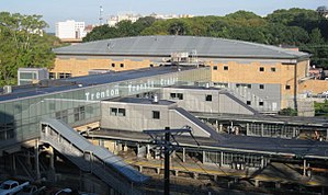
Trenton Transit Center
Train station in Trenton, New Jersey
Distance: Approx. 981 meters
Latitude and longitude: 40.21888889,-74.75416667
Trenton Transit Center is the main passenger train station in Trenton, New Jersey. It is the southernmost stop in New Jersey on the Northeast Corridor. It is the terminus for NJ Transit trains to and from New York City and SEPTA Trenton Line Regional Rail trains to and from Philadelphia, Pennsylvania, and an intermediate station for Amtrak trains traveling between the two cities along the Northeast Corridor.
Trenton Central High School
High school in Mercer County, New Jersey, United States
Distance: Approx. 250 meters
Latitude and longitude: 40.218986,-74.744269
Trenton Central High School is a three-year comprehensive public high school that serves students in tenth through twelfth grades from Trenton, in Mercer County, in the U.S. state of New Jersey, operating as part of the Trenton Public Schools. As of the 2022–23 school year, the school had an enrollment of 2,255 students and 155.9 classroom teachers (on an FTE basis), for a student–teacher ratio of 14.5:1. There were 1,179 students (52.3% of enrollment) eligible for free lunch and 80 (3.5% of students) eligible for reduced-cost lunch.

Chambersburg, Trenton, New Jersey
Populated place in Mercer County, New Jersey, US
Distance: Approx. 768 meters
Latitude and longitude: 40.21083333,-74.74694444
Chambersburg is a neighborhood located within the city of Trenton in Mercer County, in the U.S. state of New Jersey. It is considered part of South Trenton. Chambersburg was an independent municipality from 1872 to 1888.
De Lorenzo's Tomato Pies
Restaurant in New Jersey, United States
Distance: Approx. 884 meters
Latitude and longitude: 40.21107,-74.74982
De Lorenzo's Tomato Pies is a pizzeria that sells Trenton tomato pies in Robbinsville, New Jersey. It was founded in 1936 by Alexander "Chick" De Lorenzo and officially established in 1947 in Trenton, New Jersey. Since then it has expanded to another location in Robbinsville and has closed its original location in Trenton.

In and Out Social Club
United States historic place
Distance: Approx. 1124 meters
Latitude and longitude: 40.20944444,-74.75166667
In and Out Social Club is located in Trenton, Mercer County, New Jersey, United States. The building was built in 1893 and was added to the National Register of Historic Places on March 26, 1987. It was founded on September 2, 1889 for "social, intellectual, and recreative purposes." Its significance lies primarily in that the building was designed and built specifically for a social club based in the community.
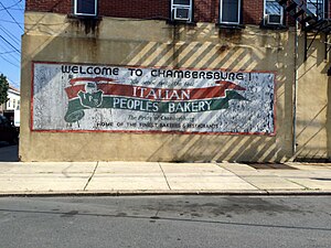
Italian Peoples Bakery
Bakeries of the United States
Distance: Approx. 863 meters
Latitude and longitude: 40.21269,-74.75134
Italian Peoples Bakery is a bakery and delicatessen founded in 1936 and located in the Chambersburg neighborhood of Trenton, New Jersey. The bakery expanded to wholesale distribution of products and now serves parts of Pennsylvania and New Jersey.

Wilbur, Trenton, New Jersey
Populated place in Mercer County, New Jersey, US
Distance: Approx. 934 meters
Latitude and longitude: 40.22527778,-74.74111111
Wilbur is a neighborhood located within the city of Trenton in Mercer County, in the U.S. state of New Jersey. It was an independent borough from 1891 to 1898. Wilbur was incorporated as a borough by an act of the New Jersey Legislature on April 24, 1891, from portions of Hamilton Township, based on the results of a referendum held six days earlier.
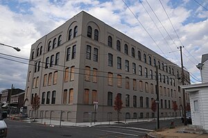
American Cigar Company (Trenton, New Jersey)
United States historic place
Distance: Approx. 545 meters
Latitude and longitude: 40.21230556,-74.74472222
The American Cigar Company Building in the Chambersburg neighborhood of Trenton, New Jersey was established in 1903 by Albert Gold. In 1931 it employed 840 workers. It was added to the National Register of Historic Places in 2011 and has been converted into residential lofts.

John A. Roebling's Sons Company, Trenton N.J., Block 3
United States historic place
Distance: Approx. 1151 meters
Latitude and longitude: 40.21266667,-74.75519444
John A. Roebling's Sons Company, Trenton N.J., Block 3 is the northern portion of the former Roebling manufacturing complex in Trenton, New Jersey. The buildings date from 1908–1929 and the site was added to the National Register of Historic Places on August 22, 2012.
St. Francis Medical Center (Trenton, New Jersey)
Distance: Approx. 130 meters
Latitude and longitude: 40.21675,-74.74141
St. Francis Medical Center is a hospital within the City of Trenton, New Jersey located on Hamilton Avenue and was owned by Trinity Health.
Art All Night shooting
Mass shooting in Trenton, New Jersey
Distance: Approx. 1149 meters
Latitude and longitude: 40.20975,-74.75252
Nearly 1,000 people were at the Art All Night event located at Roebling Wire Works Building, in Trenton, New Jersey on June 17, 2018, when multiple people began to shoot at one another, with one individual killed and 22 injured.
Statue of Christopher Columbus (Trenton, New Jersey)
Distance: Approx. 463 meters
Latitude and longitude: 40.2149,-74.7476
Statue of Christopher Columbus was installed at Christopher Columbus Park in Trenton, New Jersey, United States. The memorial was removed in July 2020.
Weather in this IP's area
clear sky
20 Celsius
21 Celsius
19 Celsius
22 Celsius
1016 hPa
86 %
1016 hPa
1014 hPa
10000 meters
05:54:24
20:16:14