Country:
 Romania
Region:
City:
Latitude and Longitude:
Time Zone:
Postal Code:
IP information under different IP Channel
ip-api
Country
Region
City
ASN
Time Zone
ISP
Blacklist
Proxy
Latitude
Longitude
Postal
Route
IPinfo
Country
Region
City
ASN
Time Zone
ISP
Blacklist
Proxy
Latitude
Longitude
Postal
Route
MaxMind
Country
Region
City
ASN
Time Zone
ISP
Blacklist
Proxy
Latitude
Longitude
Postal
Route
Luminati
Country
RORegion
tl
City
macin
ASN
Time Zone
Europe/Bucharest
ISP
Orange Romania S.A.
Latitude
Longitude
Postal
db-ip
Country
Region
City
ASN
Time Zone
ISP
Blacklist
Proxy
Latitude
Longitude
Postal
Route
ipdata
Country
Region
City
ASN
Time Zone
ISP
Blacklist
Proxy
Latitude
Longitude
Postal
Route
Popular places and events near this IP address
Freidorf
District of Timișoara in Romania
Distance: Approx. 8886 meters
Latitude and longitude: 45.72833333,21.18111111
Freidorf (German for "free village"; Hungarian: Szabadfalu) was one of the first German settlements in Temes County in the Banat, Kingdom of Hungary. In 1920, it became part of Romania; since 1950 it is a district of the city of Timișoara, located on the southwest outskirts of the city. Freidorf maintains historic architecture, old Banat Swabian houses, and many green spaces.

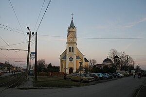
Giroc
Commune in Timiș, Romania
Distance: Approx. 7274 meters
Latitude and longitude: 45.7,21.23333333
Giroc (Hungarian: Gyüreg; German: Girok) is a commune in Timiș County, Romania. It is composed of two villages, Chișoda and Giroc (commune seat). It is located near Timișoara, south of the city.

Pădureni, Timiș
Commune in Timiș, Romania
Distance: Approx. 6284 meters
Latitude and longitude: 45.6,21.21666667
Pădureni (until 1965 Lighed; Hungarian: Temesliget; German: Paduren; Ukrainian: Гусарька; Turkish: Erdevik) is a commune in Timiș County, Romania. It is composed of a single village, Pădureni. It was part of Jebel commune before being split off in 2004.
Parța
Commune in Timiș, Romania
Distance: Approx. 3703 meters
Latitude and longitude: 45.63333333,21.13333333
Parța (Hungarian: Parác; German: Paratz; Serbian: Парац, romanized: Parac) is a commune in Timiș County, Romania. It is composed of a single village, Parța, and was part of Șag commune until 2004.

Sânmihaiu Român
Commune in Timiș, Romania
Distance: Approx. 9179 meters
Latitude and longitude: 45.7,21.08333333
Sânmihaiu Român (Hungarian: Bégaszentmihály or Oláhszentmihály; German: Wallachisch St. Michael) is a commune in Timiș County, Romania. It is composed of three villages: Sânmihaiu German, Sânmihaiu Român (commune seat) and Utvin.
Șag
Commune in Timiș, Romania
Distance: Approx. 760 meters
Latitude and longitude: 45.6517,21.1669
Șag (Hungarian: Temesság; German: Schag) is a commune in Timiș County, Romania. It is composed of a single village, Șag; Parța village broke off as a separate commune in 2004.

Shopping City Timișoara
Shopping mall in Timișoara, Romania
Distance: Approx. 8595 meters
Latitude and longitude: 45.72398056,21.19953611
Shopping City Timișoara is a shopping mall located in Timișoara, Romania. At the time of its completion, it was the second shopping mall in Timișoara. In the first year since its opening in 2016, Shopping City Timișoara had a traffic of over nine million visitors.
Fratelia
District of Timișoara in Romania
Distance: Approx. 8753 meters
Latitude and longitude: 45.72212222,21.21548889
Fratelia (Hungarian: Újkissoda, also Újtesöld; German: Neukischoda, also Neutischold), known until 1925 as Chișoda Nouă, is a district in southern Timișoara. Fratelia was in the past divided into two areas: Fratelia A, located towards Calea Șagului and Fratelia B, located towards Calea Martirilor.

Timișoara South railway station
Railway station in Romania
Distance: Approx. 7813 meters
Latitude and longitude: 45.71611111,21.20305556
Timișoara South railway station is a station located in Fratelia district of Timișoara. Crossed by the CFR Lines 922 (Timișoara–Stamora Moravița) and 918 (Timișoara–Buziaș–Lugoj), the station is transited daily by 27 trains operated by Regio Călători and CFR Călători. The station has 10 lines.

Timișoara West railway station
Railway station in Timișoara, Romania
Distance: Approx. 8603 meters
Latitude and longitude: 45.72583333,21.17166667
Timișoara West railway station is a station located in Freidorf district of Timișoara. Crossed by CFR Line 926 (Timișoara–Cruceni), the station is currently transited mainly by freight trains serving the fuel depots in the area; a single passenger train connects Timișoara to Cruceni, a village located 49 km from the city. Traffic on the 49-km-long Timișoara–Cruceni railway began on 31 July 1897.

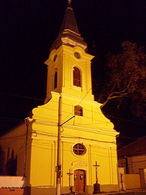
Fratelia Roman Catholic Church
Catholic church in Fratella, Romania
Distance: Approx. 8985 meters
Latitude and longitude: 45.72583333,21.20916667
The St. Joseph Church is a Roman Catholic church in the Fratelia district of Timișoara in western Romania. In the church the liturgies are celebrated in Hungarian, German and Romanian.
Dâmbovița, Timișoara
Distance: Approx. 9876 meters
Latitude and longitude: 45.7357945,21.1990196
Dâmbovița is a district in southern Timișoara. Its name comes from the homonymous boulevard that crosses it from west to east. It is a district created for the labor migration produced when the communist regime decided to accelerate industrialization.
Weather in this IP's area
clear sky
30 Celsius
29 Celsius
29 Celsius
30 Celsius
1015 hPa
26 %
1015 hPa
1006 hPa
10000 meters
1.91 m/s
2.27 m/s
348 degree
06:14:18
21:09:02