Country:
 Portugal
Region:
City:
Latitude and Longitude:
Time Zone:
Postal Code:
IP information under different IP Channel
ip-api
Country
Region
City
ASN
Time Zone
ISP
Blacklist
Proxy
Latitude
Longitude
Postal
Route
IPinfo
Country
Region
City
ASN
Time Zone
ISP
Blacklist
Proxy
Latitude
Longitude
Postal
Route
MaxMind
Country
Region
City
ASN
Time Zone
ISP
Blacklist
Proxy
Latitude
Longitude
Postal
Route
Luminati
Country
PTRegion
11
City
lisbon
ASN
Time Zone
Europe/Lisbon
ISP
Servicos De Comunicacoes E Multimedia S.A.
Latitude
Longitude
Postal
db-ip
Country
Region
City
ASN
Time Zone
ISP
Blacklist
Proxy
Latitude
Longitude
Postal
Route
ipdata
Country
Region
City
ASN
Time Zone
ISP
Blacklist
Proxy
Latitude
Longitude
Postal
Route
Popular places and events near this IP address

Mafra, Portugal
Municipality in Lisbon, Portugal
Distance: Approx. 521 meters
Latitude and longitude: 38.94111111,-9.33194444
Mafra (Portuguese pronunciation: [ˈmafɾɐ] ) is a city and a municipality in the district of Lisbon, on the west coast of Portugal, and part of the urban agglomeration of the Greater Lisbon subregion. The population in 2011 was 76,685, in an area of 291.66 km2. It is mostly known for the sumptuous Mafra National Palace inscribed as a UNESCO World Heritage Site.

Ericeira
Civil parish in Lisbon, Portugal
Distance: Approx. 8277 meters
Latitude and longitude: 38.962,-9.418
Ericeira (Portuguese pronunciation: [eɾiˈsɐjɾɐ]) is a civil parish and seaside community on the western coast of Portugal (in Mafra municipality, located 35km northwest of the center of Lisbon, about 45km by road) considered the surfing capital of Europe. It is also one of only two European spots among the World Surfing Reserves because of its exceptional coastline conditions. Ericeira's population in 2011 was estimated in 10,260, covering an area of 12 km2.

Tapada Nacional de Mafra
Park in Mafra, Portugal
Distance: Approx. 3152 meters
Latitude and longitude: 38.9527769,-9.2965775
The Tapada Nacional de Mafra was created in Mafra, Portugal, during the reign of king João V, following the building of the Mafra National Palace, as a park for royal and court recreation. Covering over 8 square kilometres, the park holds different species of deer, wild boar, foxes, birds of prey and many others coexisting in an unusually rich and diversified natural habitat. A favourite of the Portuguese monarchy for hunting and other leisure pursuits, the Tapada de Mafra took on a noble connotation that has done much to aid its preservation and continuity.
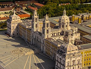
Palace of Mafra
Historic baroque and neoclassical palace-monastery in Mafra, Portugal
Distance: Approx. 189 meters
Latitude and longitude: 38.9369,-9.3258
The Palace of Mafra (Portuguese: Palácio de Mafra), also known as the Palace-Convent of Mafra and the Royal Building of Mafra (Real Edifício de Mafra), is a monumental Baroque and Neoclassical palace-monastery located in Mafra, Portugal, some 28 kilometres from Lisbon. Construction began in 1717 under King John V of Portugal and was completely concluded in 1755. The palace was classified as a National Monument in 1910 and was also a finalist in the Seven Wonders of Portugal.

Archaeological Museum of São Miguel de Odrinhas
Museum in Portugal
Distance: Approx. 6576 meters
Latitude and longitude: 38.8871,-9.3663
The Archaeological Museum of São Miguel de Odrinhas in Sintra municipality, Lisbon District, Portugal owes its existence to the collection by the Hermitage of São Miguel of epigraphic stones found amongst the Roman ruins in the neighbourhood. Around the year 30 B.C. Olisipo (Roman Lisbon) received from Augustus the status that allowed it to combine Roman law with its own ancient laws, thus permitting full integration into the Roman Empire. Most of its important families lived outside Lisbon in villas and many of the estates were located in the Sintra area.

Igreja de Santo André (Mafra)
Distance: Approx. 1089 meters
Latitude and longitude: 38.9364831,-9.3400047
Igreja de Santo André is a gothic church in Mafra, Portugal. It is classified as a National Monument.

Barreira Megalithic Complex
Megalithic site near Sintra, Portugal
Distance: Approx. 7085 meters
Latitude and longitude: 38.88416667,-9.37138889
The Barreira Megalithic Complex (Portuguese: Conjunto Megalítico de Barreira) is located in the Sintra municipality in the Lisbon District of Portugal. Situated on a small wooded hill overlooking the village of Odrinhas, site of Roman ruins and an archaeological museum, it consists of about twenty menhirs and other monoliths or megaliths. The site, which is assumed to be a dolmen or cromlech, contains mainly cylindrical stones of varying heights, with the largest being approximately four metres tall.

Fort of Zambujal
19th-century fort in Portugal
Distance: Approx. 5503 meters
Latitude and longitude: 38.94916667,-9.38944444
The Fort of Zambujal, also referred to as the Fort of Casas Velhas, is located near the town of Zambujal-Casas Velhas, in the parish of Carvoeira, municipality of Mafra, Lisbon District, Portugal. Constructed in 1809–10, at 102 metres above sea level, it was one of the forts and other military works built by British and Portuguese troops to protect Lisbon from French forces, forming part of the Second Line of defence of the so-called Lines of Torres Vedras. Each work was given a number and Zambujal was No.

Fort of Feira
19th Century fort in Portugal
Distance: Approx. 6287 meters
Latitude and longitude: 38.93583333,-9.255
The Fort of Feira, also known as the Fort of Malveira, is located at an altitude of 226 metres, above the town of Malveira, in the municipality of Mafra, in Lisbon District, Portugal. It was built in 1809-10 as part of the Lines of Torres Vedras, three lines of forts and redoubts designed to protect Lisbon against French troops. The fort was reopened to the public in 2011.

Royal and Venerable Confraternity of the Most Blessed Sacrament of Mafra
Distance: Approx. 194 meters
Latitude and longitude: 38.93716667,-9.32552778
The Royal and Venerable Confraternity of the Most Blessed Sacrament of Mafra, alternatively, the Royal and Venerable Brotherhood of the Most Blessed Sacrament of Mafra (Portuguese: Real e Venerável Irmandade do Santíssimo Sacramento de Mafra), is a public association of faithful of the Catholic Church, canonically established in the Basilica of Our Lady and Saint Anthony of Mafra, Portugal. The confraternity is one of the oldest institutions in the municipality of Mafra. It organizes the Corpus Christi solemnity and organizes the four traditional processions of the season of Lent in Mafra: The procession of the Passion of the Lord (Portuguese: Procissão do Senhor Jesus dos Passos); The procession of Penance of the Third Order of Saint Francis (Portuguese: Procissão de Penitência da Ordem Terceira de São Francisco); The procession of Seven Sorrows of Our Lady (Portuguese: Procissão das Sete Dores de Nossa Senhora); and The procession of the Burial of the Lord (Portuguese: Procissão do Enterro do Senhor).
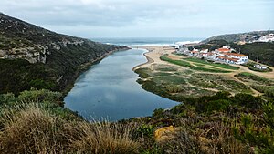
Lizandro River
River in Lisbon, Portugal
Distance: Approx. 7644 meters
Latitude and longitude: 38.941674,-9.415708
The Lizandro (Portuguese pronunciation: [liˈzɐ̃dɾu]) also known as Ribeira do Mourão, Ribeira de Anços, Ribeira dos Tostões, Ribeira de Cheleiros, is a river in the district of Lisbon, Portugal. The exact location of its source is unknown, due to a lack of studies. Its mouth is located in Carvoeira, Mafra, Portugal, on a beach named Foz do Lizandro, which has a Blue Flag beach certification.

Basilica of Our Lady and Saint Anthony of Mafra
Church in Mafra, Portugal
Distance: Approx. 150 meters
Latitude and longitude: 38.9369,-9.3264
The Basilica of Our Lady and Saint Anthony of Mafra is a Roman Catholic shrine and basilica located within the Palace of Mafra, Portugal. It is designated as a Basilica by the privilege of immemorial status. The shrine is dedicated to the Blessed Virgin Mary and Saint Anthony of Padua which once fostered religious devotion among the Portuguese nobility.
Weather in this IP's area
clear sky
21 Celsius
20 Celsius
19 Celsius
24 Celsius
1022 hPa
34 %
1022 hPa
996 hPa
10000 meters
2.35 m/s
1.99 m/s
319 degree
7 %
07:31:33
19:23:22