Country:
 Portugal
Region:
City:
Latitude and Longitude:
Time Zone:
Postal Code:
IP information under different IP Channel
ip-api
Country
Region
City
ASN
Time Zone
ISP
Blacklist
Proxy
Latitude
Longitude
Postal
Route
IPinfo
Country
Region
City
ASN
Time Zone
ISP
Blacklist
Proxy
Latitude
Longitude
Postal
Route
MaxMind
Country
Region
City
ASN
Time Zone
ISP
Blacklist
Proxy
Latitude
Longitude
Postal
Route
Luminati
Country
PTRegion
11
City
lisbon
ASN
Time Zone
Europe/Lisbon
ISP
Servicos De Comunicacoes E Multimedia S.A.
Latitude
Longitude
Postal
db-ip
Country
Region
City
ASN
Time Zone
ISP
Blacklist
Proxy
Latitude
Longitude
Postal
Route
ipdata
Country
Region
City
ASN
Time Zone
ISP
Blacklist
Proxy
Latitude
Longitude
Postal
Route
Popular places and events near this IP address

Belém Palace
Official residence of the President of the Portuguese Republic, in Lisbon
Distance: Approx. 682 meters
Latitude and longitude: 38.69796944,-9.20068611
The Belém Palace (Portuguese: Palácio de Belém), formally the National Palace of Belém, (Portuguese: Palácio Nacional de Belém), is the current official residence of the president of the Portuguese Republic, the head of state of Portugal. Located in the Belém District of Lisbon, the palace's main façade fronts the Praça Afonso de Albuquerque, facing the Tagus River. A former residence of the Portuguese royal family, the Belém Palace complex is made up of various buildings, wings, courtyards, and gardens, built variously from the 18th to 21st centuries.

Lisbon District
District of Portugal
Distance: Approx. 843 meters
Latitude and longitude: 38.7,-9.18333333
Lisbon District (Portuguese: Distrito de Lisboa) is a district located along the western coast of Portugal. The district capital is the city of Lisbon, which is also the national capital. From its creation in 1835 until 1926, it included the area of the current Setúbal District.

Kingdom of Portugal
Kingdom in Southwestern Europe (1139–1910)
Distance: Approx. 843 meters
Latitude and longitude: 38.7,-9.18333333
The Kingdom of Portugal was a monarchy in the western Iberian Peninsula and the predecessor of the modern Portuguese Republic. Existing to various extents between 1139 and 1910, it was also known as the Kingdom of Portugal and the Algarves after 1415, and as the United Kingdom of Portugal, Brazil and the Algarves between 1815 and 1822. The name is also often applied to the Portuguese Empire, the realm's overseas colonies.

Afonso de Albuquerque Square
Distance: Approx. 688 meters
Latitude and longitude: 38.69662222,-9.20034722
Afonso de Albuquerque Square (Portuguese: Praça Afonso de Albuquerque) is a public square in the Belém district of the city of Lisbon, Portugal.

National Coach Museum
Museum in Lisbon, Portugal
Distance: Approx. 602 meters
Latitude and longitude: 38.69777778,-9.19972222
The National Coach Museum (Portuguese: Museu Nacional dos Coches) is located on the Afonso de Albuquerque Square in the Belém district of Lisbon in Portugal. The museum has one of the finest collections of historical carriages in the world and is one of the most visited museums of the city.

Electricity Museum
Distance: Approx. 381 meters
Latitude and longitude: 38.69583333,-9.19527778
Tejo Power Station (the old Electricity Museum, in Portuguese Museu da Electricidade) is a cultural centre that presents the evolution of energy with a Museum of Science and Industrial Archaeology concept, where themed and experimental exhibits live side by side with a great variety of cultural events. Located in the Belém area on terrain Lisbon usurped from the Tagus river (Tejo in Portuguese) at the end of the 19th century, in one of the city's areas with the greatest concentration of historical monuments where one can find, among others, the Jerónimos Monastery, the Belém Cultural Centre, the Tower of Belém, the Padrão dos Descobrimentos, the Portuguese Presidential Palace and Museum, the Coach Museum or the Cordoaria Nacional (national rope factory). A building classified as a Public Interest Project, the Electricity Museum unfolds along the perimeter of the old thermoelectric plant – the Tejo Power Station, which illuminated the city of Lisbon for more than four decades.

Tejo Power Station
Historical power station
Distance: Approx. 420 meters
Latitude and longitude: 38.69555556,-9.19555556
The Tejo Power Station was a thermoelectric power plant owned by the Companhias Reunidas de Gás e Electricidade (CRGE – United Gas and Electric Companies), which supplied power to the city and entire Lisbon region. It is located in the Belém district of Portugal's capital and its activity spanned from 1909 to 1972, although as of 1951 it was used as a reserve power station. Over time, it underwent several adjustments and expansions, going through many different phases of construction and production.
Tejo Power Station (architectural ensemble)
Distance: Approx. 385 meters
Latitude and longitude: 38.69555556,-9.19472222
The Tejo Power Station is a former coal-fired power station in the Belém district of Lisbon, Portugal that operated from 1908 to 1975. It now houses the Museu da Electricidade (Electricity Museum) complex.

Burnay Palace
Historic site in Lisbon, Portugal
Distance: Approx. 732 meters
Latitude and longitude: 38.6999283,-9.1846152
Burnay Palace (Portuguese: Palácio Burnay) is a palace in the Alcântara parish in Lisbon, Portugal.

Terras do Desembargador
Distance: Approx. 386 meters
Latitude and longitude: 38.699829,-9.197093
Terras do Desembargador, also known as Campo das Salésias, was a football dirt field in Lisbon, Portugal. It hosted football matches of Sport Lisboa. In 1903, football was a growing sport, and Terras do Desembargador was Lisbon's main field for playing football.
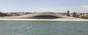
Museum of Art, Architecture and Technology
Museum in Lisbon, Portugal
Distance: Approx. 346 meters
Latitude and longitude: 38.69591,-9.19464
The Museum of Art, Architecture and Technology (Portuguese: Museu de Arte, Arquitetura e Tecnologia) (MAAT) is a museum in Lisbon, Portugal.

Cordoaria Nacional
Former naval rope-making factory in Belém, Portugal
Distance: Approx. 262 meters
Latitude and longitude: 38.6975,-9.1903
The Cordoaria Nacional was a former naval rope-making factory in Belém, Lisbon District, Portugal. It now functions as an exhibition centre.
Weather in this IP's area
clear sky
23 Celsius
22 Celsius
22 Celsius
23 Celsius
1022 hPa
40 %
1022 hPa
1020 hPa
10000 meters
3.09 m/s
70 degree
07:30:57
19:22:53