Country:
 Germany
Region:
City:
Latitude and Longitude:
Time Zone:
Postal Code:
IP information under different IP Channel
ip-api
Country
Region
City
ASN
Time Zone
ISP
Blacklist
Proxy
Latitude
Longitude
Postal
Route
IPinfo
Country
Region
City
ASN
Time Zone
ISP
Blacklist
Proxy
Latitude
Longitude
Postal
Route
MaxMind
Country
Region
City
ASN
Time Zone
ISP
Blacklist
Proxy
Latitude
Longitude
Postal
Route
Luminati
Country
DEASN
Time Zone
Europe/Berlin
ISP
euNetworks GmbH
Latitude
Longitude
Postal
db-ip
Country
Region
City
ASN
Time Zone
ISP
Blacklist
Proxy
Latitude
Longitude
Postal
Route
ipdata
Country
Region
City
ASN
Time Zone
ISP
Blacklist
Proxy
Latitude
Longitude
Postal
Route
Popular places and events near this IP address

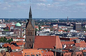
Leineschloss
Palace in Hanover, seat of the parliament of Lower Saxony
Distance: Approx. 27 meters
Latitude and longitude: 52.37055556,9.73361111
The Leine Palace (German: Leineschloss), situated on the Leine in Hanover, Germany, is a former residence of the Hanoverian dukes, electors and kings. It is now the seat of the parliament (Landtag) of Lower Saxony. The first building on the site was a Franciscan friary, constructed in about 1300, which was abandoned in 1533 after the Protestant Reformation.
Marktkirche, Hanover
Church in Hanover, Lower Saxony
Distance: Approx. 161 meters
Latitude and longitude: 52.371789,9.735329
The Market Church (German: Marktkirche, meaning 'church at the market place') is the main Lutheran church in Hanover, Germany. Built in the 14th century, it was referred to in 1342 as the church of Saints James and George (Latin: ecclesia sanctorum Jacobi et Georgii) in dedication to Saint James the Elder and Saint George. Replacing an older, smaller, church at the same location that dated to 1125 and that is known to have been called St.

Museum August Kestner
Museum in Hanover, Lower Saxony
Distance: Approx. 351 meters
Latitude and longitude: 52.368099,9.736265
The August Kestner Museum (German: Museum August Kestner), previously Kestner-Museum, is a museum in Hanover, Germany. Founded in 1889, the museum was renamed in December 2007 to avoid confusion with the Kestnergesellschaft, a local art gallery. The museum centres on the collections of August Kestner and his nephew Hermann Kestner, later followed by the collections of Friedrich Culemann and Friedrich Wilhelm von Bissing.

Neustädter Kirche, Hanover
Church in Hanover, Lower Saxony
Distance: Approx. 348 meters
Latitude and longitude: 52.371165,9.728522
The New Town Church (German: Neustädter Kirche) is a main Lutheran parish church in Hanover, Germany. Its official name is St. John's Church of the court and city in the New Town at Hanover (Neustädter Hof- und Stadtkirche St.

Markthalle/Landtag (Hanover Stadtbahn station)
Distance: Approx. 173 meters
Latitude and longitude: 52.37055556,9.73611111
Markthalle/Landtag is an underground station on the Hanover Stadtbahn, served by the A lines. This station consists of a mezzanine level and two side platforms.

Kreuzkirche, Hanover
Church in Hanover, Lower Saxony
Distance: Approx. 296 meters
Latitude and longitude: 52.373391,9.732596
The Church of the Holy Cross (German: Kreuzkirche) is a Lutheran church in the centre of Hanover, the capital of Lower Saxony, Germany. A Gothic hall church, it is one of three churches in Hanover's old town (Altstadt) – the other two being Market Church and Aegidien Church, although the latter is now a war memorial. During the Reformation the church became Lutheran.

Old Town Hall (Hanover)
Former town hall in Hanover, Germany
Distance: Approx. 171 meters
Latitude and longitude: 52.371225,9.736018
The Old Town Hall (German: Altes Rathaus) is a former, and the first, town hall in Hanover, Germany. Originally built in the old city district in 1410, replaced by the New Town Hall in 1913, and extensively restored in 1953 and 1964 after heavy bomb damage in World War II, it is the oldest secular building in the city. The market façade with the highly sophisticated Brick Gothic of the lucarnes has been preserved and partly restored in its medieval shape.

Historisches Museum Hannover
Museum in Hanover, Germany
Distance: Approx. 144 meters
Latitude and longitude: 52.371791,9.73224
Hanover Historical Museum (German: Historisches Museum Hannover) is an historical museum situated in Hanover, the capital of Lower Saxony, Germany. The museum was founded in 1903 as the Homeland Museum of the City of Hanover (Vaterländisches Museum der Stadt Hannover). Its collections are related to the history of the city, the history of the House of Guelf, and of the state of Lower Saxony.

Broyhan House
Half-timbered building in Hanover, Germany
Distance: Approx. 111 meters
Latitude and longitude: 52.371736,9.734158
Broyhan House (German: Broyhanhaus) is a residential and commercial building constructed in 1576 in Hanover's historic old town (Altstadt). It is the second-oldest preserved half-timbered building in Hanover, and stands on the cellar walls of an earlier building dating to the 14th century. The house is named after Cord Broyhan, a brewer who lived in an earlier building from 1537 until 1561.

Wangenheim Palace
Building in Hanover, Germany
Distance: Approx. 197 meters
Latitude and longitude: 52.36916667,9.73472222
Wangenheim Palace (German: Wangenheimpalais) is a building in the Mitte district of Hanover, the capital of Lower Saxony, Germany. From 1863 to 1913, it was the town hall and seat of the city's administration. Today it is the seat of the Lower Saxon Ministry of Economic Affairs.
Bekleidungshaus Otto Werner
Former clothing store in Hanover, Lower Saxony
Distance: Approx. 351 meters
Latitude and longitude: 52.373092,9.737156
The Otto Werner clothing store (Bekleidungshaus Otto Werner) opened in 1932 in Hanover, the capital of Lower Saxony, Germany. By 1985, the store had expanded to several branches throughout the state. After the original store closed in 1999, the enterprise ceased operating in 2001.

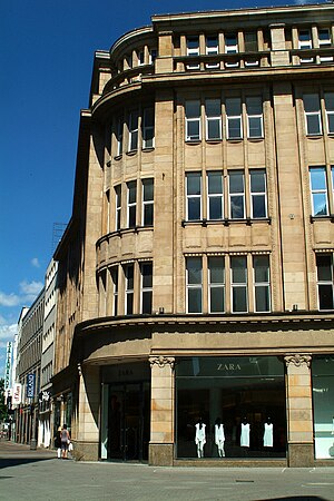
Elsbach & Frank
Former department store in Hanover, Lower Saxony
Distance: Approx. 351 meters
Latitude and longitude: 52.373092,9.737156
Elsbach & Frank was a textile retail business founded in the 19th century in Hanover, the capital of Lower Saxony, Germany. The department store (Kaufhaus) built by the business on the corner of Osterstraße and Große Packhofstraße, called Zum Stern, is the only building in the city centre that survived the air raids on Hanover during the Second World War without major damage. Today, the building houses a branch of the Spanish fashion chain Zara.
Weather in this IP's area
clear sky
19 Celsius
18 Celsius
17 Celsius
20 Celsius
1022 hPa
76 %
1022 hPa
1015 hPa
10000 meters
2.06 m/s
90 degree
05:37:07
21:17:43