Country:
 Netherlands
Region:
City:
Latitude and Longitude:
Time Zone:
Postal Code:
IP information under different IP Channel
ip-api
Country
Region
City
ASN
Time Zone
ISP
Blacklist
Proxy
Latitude
Longitude
Postal
Route
IPinfo
Country
Region
City
ASN
Time Zone
ISP
Blacklist
Proxy
Latitude
Longitude
Postal
Route
MaxMind
Country
Region
City
ASN
Time Zone
ISP
Blacklist
Proxy
Latitude
Longitude
Postal
Route
Luminati
Country
NLASN
Time Zone
Europe/Amsterdam
Latitude
Longitude
Postal
db-ip
Country
Region
City
ASN
Time Zone
ISP
Blacklist
Proxy
Latitude
Longitude
Postal
Route
ipdata
Country
Region
City
ASN
Time Zone
ISP
Blacklist
Proxy
Latitude
Longitude
Postal
Route
Popular places and events near this IP address

Rotterdam
City in South Holland, Netherlands
Distance: Approx. 288 meters
Latitude and longitude: 51.92,4.48
Rotterdam ( ROT-ər-dam, UK also ROT-ər-DAM, Dutch: [ˌrɔtərˈdɑm] ; lit. "The Dam on the River Rotte") is the second-largest city in the Netherlands after the national capital of Amsterdam. It is in the province of South Holland, part of the North Sea mouth of the Rhine–Meuse–Scheldt delta, via the "New Meuse" inland shipping channel, dug to connect to the Meuse at first and now to the Rhine.

Lijnbaan
Distance: Approx. 307 meters
Latitude and longitude: 51.92,4.477
The Lijnbaan is the main shopping street of Rotterdam. It was opened in 1953, as the main pedestrian street in the new shopping district, after the old shopping district was completely destroyed during the bombing of Rotterdam by the German Luftwaffe. It was designed by the firm Van den Broek & Bakema led by architects Jo van den Broek and Jacob B. Bakema.

Stadhuis metro station
Distance: Approx. 101 meters
Latitude and longitude: 51.92333333,4.47833333
Stadhuis (Dutch for town hall) is an underground subway station in the city of Rotterdam, and is located on Rotterdam Metro lines D and E. The station opened on 9 February 1968, the same date that the North-South Line (also temporarily called Erasmus line), of which it is a part, was opened. The station is located in the center of Rotterdam, underneath the Coolsingel, a major street through the center.

Westerkerk (Rotterdam)
Distance: Approx. 255 meters
Latitude and longitude: 51.9223,4.4752
The Westerkerk (Dutch pronunciation: [ʋɛstərkɛr(ə)k]; English: Western Church) was a Protestant church on the Kruiskade in Rotterdam, Netherlands completed in 1870 and destroyed in the bombing of Rotterdam in May 1940. The Westerkerk was designed by architect J.A. Jurriaanse in an eclectic mix of styles, the tower was neo-Gothic, front and side walls Neo-Romanesque and the interior referred to the seventeenth-century Protestant churches, like the New Church in Haarlem. The church was fully paid for by the Dutch Reformed Church itself.
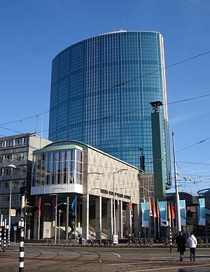
Beurs-World Trade Center
Office in Rotterdam, Netherlands
Distance: Approx. 240 meters
Latitude and longitude: 51.92083333,4.48111111
Beurs-World Trade Center is located on the Coolsingel and Beursplein in the centre of Rotterdam. It is a major business centre in Rotterdam with approximately 200 offices. The building is 93 meters high.

Trams in Rotterdam
Distance: Approx. 178 meters
Latitude and longitude: 51.92166667,4.48111111
The Rotterdam tramway network (Dutch: Rotterdams tramnet) is a key element of the overall public transport arrangements in Rotterdam, Netherlands. Opened in 1879, the network currently has nine regular tramlines, and three special or seasonal tramlines. It has been operated since 1927 by Rotterdamse Elektrische Tram (RET).

Coolsingel
Street in central Rotterdam, Netherlands
Distance: Approx. 31 meters
Latitude and longitude: 51.92272222,4.47863889
Coolsingel is a street in central Rotterdam. It is located in the Cool district. The street leads from the Hofplein to the Churchillplein.
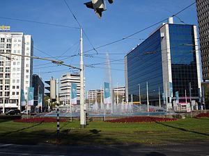
Hofplein
Town square in Rotterdam, the Netherlands
Distance: Approx. 215 meters
Latitude and longitude: 51.92430556,4.47780556
Hofplein is a major public town square in Rotterdam, the Netherlands. The square lies on a crossing of the Weena, the Schiekade and the Coolsingel. In the center of the square a large fountain is situated.

Amarone (restaurant)
Restaurant in Rotterdam, Netherlands
Distance: Approx. 330 meters
Latitude and longitude: 51.92256667,4.48370556
Amarone is a restaurant in Rotterdam, Netherlands. It is a fine dining restaurant that is awarded one Michelin star in the period 2008–present. The original head chef of Amarone was Gert Blom.

Schielandtoren
Residential in Bulgersteyn, Rotterdam
Distance: Approx. 396 meters
Latitude and longitude: 51.91932222,4.4815
The Schielandtoren (Dutch for Schieland Tower) is a 101 metres (331 feet) tall apartment building in the Dutch city Rotterdam. The building is situated along Bulgersteyn, a street, and is part of a city block with shops among other things. The city block is part of the multipurpose complex Beursplein.

Rotterdam City Hall
Seat of local government in Rotterdam
Distance: Approx. 64 meters
Latitude and longitude: 51.92277778,4.47972222
Rotterdam City Hall was built between 1914 and 1920 by Henri Evers. It is one of the few buildings in the center of Rotterdam that survived the bombing of May 14, 1940. Since 10 October 2000 it has been recognized as a Rijksmonument.
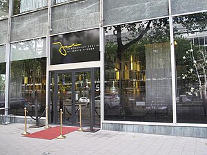
Joelia
Restaurant in Rotterdam, the Netherlands
Distance: Approx. 158 meters
Latitude and longitude: 51.923706,4.477678
Joelia is a restaurant in Rotterdam, Netherlands. The restaurant received a Michelin star in 2016. The Dutch royal couple Willem-Alexander of the Netherlands and Queen Máxima of the Netherlands celebrated their fifteenth wedding anniversary in Joelia.
Weather in this IP's area
overcast clouds
22 Celsius
22 Celsius
20 Celsius
23 Celsius
1014 hPa
65 %
1014 hPa
1013 hPa
10000 meters
3.09 m/s
260 degree
100 %
05:57:03
21:39:53