Country:
 Switzerland
Region:
City:
Latitude and Longitude:
Time Zone:
Postal Code:
IP information under different IP Channel
ip-api
Country
Region
City
ASN
Time Zone
ISP
Blacklist
Proxy
Latitude
Longitude
Postal
Route
IPinfo
Country
Region
City
ASN
Time Zone
ISP
Blacklist
Proxy
Latitude
Longitude
Postal
Route
MaxMind
Country
Region
City
ASN
Time Zone
ISP
Blacklist
Proxy
Latitude
Longitude
Postal
Route
Luminati
Country
CHRegion
zh
City
dietikon
ASN
Time Zone
Europe/Zurich
ISP
green.ch AG
Latitude
Longitude
Postal
db-ip
Country
Region
City
ASN
Time Zone
ISP
Blacklist
Proxy
Latitude
Longitude
Postal
Route
ipdata
Country
Region
City
ASN
Time Zone
ISP
Blacklist
Proxy
Latitude
Longitude
Postal
Route
Popular places and events near this IP address
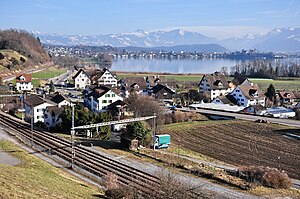
Feldbach, Switzerland
Village in Hombrechtikon, Switzerland
Distance: Approx. 2057 meters
Latitude and longitude: 47.24,8.786
Feldbach is a village near Rapperswil, Switzerland. It is located on the north bank of the lake of Zurich and is part of the political municipality of Hombrechtikon. In the local dialect it is called Fäldbach.

Bubikon
Municipality in Zurich, Switzerland
Distance: Approx. 1766 meters
Latitude and longitude: 47.26666667,8.81666667
Bubikon is a municipality in the district of Hinwil in the canton of Zürich in Switzerland.

Hombrechtikon
Municipality in Zurich, Switzerland
Distance: Approx. 2546 meters
Latitude and longitude: 47.25,8.76666667
Hombrechtikon is a municipality in the district of Meilen in the canton of Zürich in Switzerland.

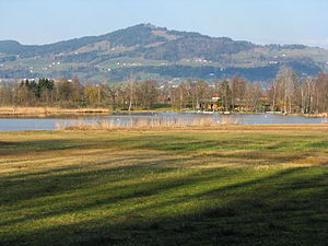
Lützelsee
Distance: Approx. 2048 meters
Latitude and longitude: 47.25972222,8.7725
Lützelsee is a lake north of Hombrechtikon, Canton of Zurich, Switzerland. Its surface area is 13 ha (32 acres).
Egelsee (Bubikon)
Lake in the canton of Zurich, Switzerland
Distance: Approx. 1339 meters
Latitude and longitude: 47.25777778,8.81666667
Egelsee is a lake in the municipality of Bubikon in the Canton of Zurich, Switzerland. Its surface area is 4.3 ha (11 acres).

Kempraten
Former municipality of Switzerland in St. Gallen
Distance: Approx. 2871 meters
Latitude and longitude: 47.23333333,8.81666667
Kempraten-Lenggis is a village (Kirchdorf) within the municipality of Rapperswil-Jona, Wahlkreis (constituency) of See-Gaster in the canton of St. Gallen in Switzerland. The remains of the Gallo-Roman settlement Centum Prata are one of the most important archaeological sites in the canton of St.

Rosenberg Estate
Distance: Approx. 2435 meters
Latitude and longitude: 47.237757,8.781768
The Rosenberg Estate (German: Landsitz Rosenberg) is a country estate in the municipality of Hombrechtikon and the canton of Zurich in Switzerland. It is a Swiss heritage site of national significance.

Kempraten railway station
Railway station in Rapperswil-Jona, Switzerland
Distance: Approx. 2292 meters
Latitude and longitude: 47.23838889,8.81430556
Kempraten railway station (German: Bahnhof Kempraten) is a railway station in Switzerland, situated near the village of Kempraten in the municipality of Rapperswil-Jona. The station is located on the Lake Zurich right bank railway line and is one of four active railway stations in Rapperswil-Jona (the others being Rapperswil, Jona and Blumenau).

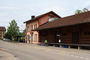
Feldbach railway station
Railway station in Switzerland
Distance: Approx. 2267 meters
Latitude and longitude: 47.23880556,8.7835
Feldbach railway station (German: Bahnhof Feldbach) is a railway station in Switzerland, situated near the village of Feldbach in the municipality of Hombrechtikon.
Bubikon railway station
Distance: Approx. 2417 meters
Latitude and longitude: 47.270705,8.822907
Bubikon is a railway station in the Swiss canton of Zurich and municipality of Bubikon. The station is located on the Wallisellen to Uster and Rapperswil railway line.

Centum Prata
Former Roman vicus in Switzerland
Distance: Approx. 2871 meters
Latitude and longitude: 47.23333333,8.81666667
Centum Prata is the name of a Roman vicus, whose remains are located on the eastern Zürichsee lakeshore in Kempraten, a locality of the municipality Rapperswil-Jona in the canton of St. Gallen in Switzerland. Centum Prata is the most important archaeological site from the Gallo-Roman era in the canton of St.

Rapperswil-Jona/Hombrechtikon–Feldbach
Archaeological site in Switzerland
Distance: Approx. 1950 meters
Latitude and longitude: 47.23879722,8.7961
Rapperswil-Jona/Hombrechtikon–Feldbach is one of the 111 serial sites of the UNESCO World Heritage Site Prehistoric pile dwellings around the Alps, of which are 56 located in Switzerland.
Weather in this IP's area
clear sky
17 Celsius
17 Celsius
15 Celsius
19 Celsius
1020 hPa
94 %
1020 hPa
962 hPa
10000 meters
4 %
06:01:08
21:01:08