Country:
 Switzerland
Region:
City:
Latitude and Longitude:
Time Zone:
Postal Code:
IP information under different IP Channel
ip-api
Country
Region
City
ASN
Time Zone
ISP
Blacklist
Proxy
Latitude
Longitude
Postal
Route
IPinfo
Country
Region
City
ASN
Time Zone
ISP
Blacklist
Proxy
Latitude
Longitude
Postal
Route
MaxMind
Country
Region
City
ASN
Time Zone
ISP
Blacklist
Proxy
Latitude
Longitude
Postal
Route
Luminati
Country
CHRegion
zh
City
dietikon
ASN
Time Zone
Europe/Zurich
ISP
green.ch AG
Latitude
Longitude
Postal
db-ip
Country
Region
City
ASN
Time Zone
ISP
Blacklist
Proxy
Latitude
Longitude
Postal
Route
ipdata
Country
Region
City
ASN
Time Zone
ISP
Blacklist
Proxy
Latitude
Longitude
Postal
Route
Popular places and events near this IP address
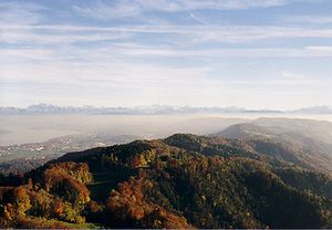
Albis
Distance: Approx. 3737 meters
Latitude and longitude: 47.28333333,8.5
The Albis is a chain of hills in the Canton of Zürich, Switzerland, stretching for some 19 km from Sihlbrugg in the south to Waldegg near Zürich in the north. The chain forms, among others, the border between the Affoltern and Horgen districts. The best known point is Uetliberg at 870 m, overlooking the city of Zürich.
Aeugst am Albis
Municipality in Zurich, Switzerland
Distance: Approx. 2698 meters
Latitude and longitude: 47.26666667,8.48333333
Aeugst am Albis is a municipality in the district of Affoltern in the canton of Zürich in Switzerland.
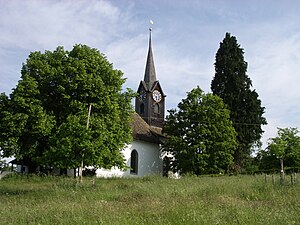
Affoltern am Albis
Swiss municipality in the canton of Zürich
Distance: Approx. 668 meters
Latitude and longitude: 47.28333333,8.45
Affoltern am Albis (abbreviated as Affoltern a.A.; Swiss German: Affoltere) is a town and a municipality in the district of Affoltern in the canton of Zürich in Switzerland.

Hedingen
Municipality in Zurich, Switzerland
Distance: Approx. 2518 meters
Latitude and longitude: 47.3,8.45
Hedingen is a municipality in the district of Affoltern in the canton of Zürich in Switzerland.

Mettmenstetten
Municipality in Zurich, Switzerland
Distance: Approx. 3264 meters
Latitude and longitude: 47.25,8.46666667
Mettmenstetten (Swiss German: Mäpmischtette) is a village in the district of Affoltern in the canton of Zürich in Switzerland.

Obfelden
Municipality in Zurich, Switzerland
Distance: Approx. 2876 meters
Latitude and longitude: 47.26666667,8.41666667
Obfelden (Swiss German: Obfälde) is a municipality in the district of Affoltern in the canton of Zürich in Switzerland.
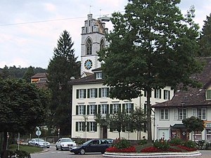
Affoltern District
District in Switzerland
Distance: Approx. 1666 meters
Latitude and longitude: 47.26666667,8.46666667
Affoltern District (also known as Knonaueramt or Säuliamt) is one of the twelve districts of the German-speaking canton of Zürich, Switzerland. Its capital is the city of Affoltern am Albis.

Affoltern am Albis railway station
Railway station in Zürich, Switzerland
Distance: Approx. 432 meters
Latitude and longitude: 47.275881,8.44604
Affoltern am Albis is a railway station in the Swiss canton of Zürich, situated in the municipality of Affoltern am Albis. The station is located on the Zürich to Zug via Affoltern am Albis railway line. Affoltern am Albis station is less than 30 minutes from Zürich Hauptbahnhof.

Hedingen railway station
Distance: Approx. 2386 meters
Latitude and longitude: 47.298507,8.445793
Hedingen is a railway station in the Swiss canton of Zurich, situated in the municipality of Hedingen. The station is located on the Zurich to Zug via Affoltern am Albis railway line. This railway station, although not a major station, provides the ability to travellers to purchase tickets for either directions.

Mettmenstetten railway station
Distance: Approx. 3730 meters
Latitude and longitude: 47.244163,8.457595
Mettmenstetten is a railway station in the Swiss canton of Zurich, situated in the municipality of Mettmenstetten. The station is located on the Zurich to Zug via Affoltern am Albis railway line.
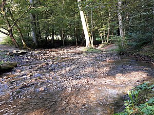
Wüeribach
Tributary of the Reppisch
Distance: Approx. 3463 meters
Latitude and longitude: 47.30557,8.47076
The Wüeribach (also called the Dorfbach and Fischbach in its upper reaches) is a tributary of the Reppisch, around 8 kilometres long, in the Canton of Zürich in Switzerland. It rises in the municipality of Bonstetten, flows through the narrow Wüerital valley and reaches the Reppisch valley near Birmensdorf, wo it empties, parallel to the rather smaller Lunnerenbach, into the lower Reppisch. The Wüeribach is the longest and biggest tributary of the Reppisch and has an average flow rate of 310 L/s.

Collection Center of the Swiss National Museum
Collection center of the Swiss Nation Museum in the canton of Zürich
Distance: Approx. 1010 meters
Latitude and longitude: 47.2691,8.4459
The collection center of the Swiss National Museum is located in Affoltern am Albis, canton of Zurich, and serves as the Swiss National Museum's depot, which also includes the conservators' workshop, handles logistics for packing and shipping cultural objects, and a photographic studio. The center was established by converting an abandoned armory from the 1980s. It is recognized as a national treasure under No.
Weather in this IP's area
clear sky
17 Celsius
17 Celsius
16 Celsius
18 Celsius
1019 hPa
84 %
1019 hPa
962 hPa
10000 meters
0.61 m/s
0.66 m/s
75 degree
5 %
06:02:28
21:02:35