Country:
 Switzerland
Region:
City:
Latitude and Longitude:
Time Zone:
Postal Code:
IP information under different IP Channel
ip-api
Country
Region
City
ASN
Time Zone
ISP
Blacklist
Proxy
Latitude
Longitude
Postal
Route
IPinfo
Country
Region
City
ASN
Time Zone
ISP
Blacklist
Proxy
Latitude
Longitude
Postal
Route
MaxMind
Country
Region
City
ASN
Time Zone
ISP
Blacklist
Proxy
Latitude
Longitude
Postal
Route
Luminati
Country
CHRegion
zh
City
dietikon
ASN
Time Zone
Europe/Zurich
ISP
green.ch AG
Latitude
Longitude
Postal
db-ip
Country
Region
City
ASN
Time Zone
ISP
Blacklist
Proxy
Latitude
Longitude
Postal
Route
ipdata
Country
Region
City
ASN
Time Zone
ISP
Blacklist
Proxy
Latitude
Longitude
Postal
Route
Popular places and events near this IP address

Reichenau Island
Island in Germany
Distance: Approx. 3100 meters
Latitude and longitude: 47.69444444,9.0625
Reichenau Island (German: [ˈʁaɪçənaʊ]) is an island in Lake Constance in Southern Germany. It lies almost due west of the city of Konstanz, between the Gnadensee and the Untersee, two parts of Lake Constance. With a total land surface of 4.3 km2 (1.7 sq mi) and a circumference of 11 km (6.8 mi), the island is 4.5 km (2.8 mi) long and 1.5 km (0.93 mi) wide at its greatest extent.

Salenstein
Municipality in Thurgau, Switzerland
Distance: Approx. 2636 meters
Latitude and longitude: 47.66666667,9.05
Salenstein is a municipality in Kreuzlingen District in the canton of Thurgau in Switzerland. Salenstein was the home village of Napoleon III, who lived at Castle Arenenberg in his youth.

Ermatingen
Municipality in Thurgau, Switzerland
Distance: Approx. 1425 meters
Latitude and longitude: 47.66666667,9.06666667
Ermatingen is a municipality in the district of Kreuzlingen in the canton of Thurgau in Switzerland.

Triboltingen
Municipality in Thurgau, Switzerland
Distance: Approx. 2322 meters
Latitude and longitude: 47.66,9.111
Triboltingen is a small village in the canton of Thurgau in Switzerland, situated on the south shore of the Untersee part of Lake Constance. Since 1975, it is politically part of Ermatingen. Triboltingen railway station on the Lake Line is served by the S1 of St.

Arenenberg
Distance: Approx. 1918 meters
Latitude and longitude: 47.67277778,9.05916667
Arenenberg is an estate with a small chateau, Schloss Arenenberg, in the municipality of Salenstein at the shore of Lake Constance in Thurgau, Switzerland that is famous as the final domicile of Hortense de Beauharnais. Today it houses the Napoleonmuseum. It is a Swiss heritage site of national significance.

Triboldingerbohl
Distance: Approx. 2842 meters
Latitude and longitude: 47.67166667,9.1225
Triboldingerbohl, also known as Triboltingen or großes Bohl or Langenrain, is the fourth largest island of Lake Constance, with an area of 0.13557 square kilometres (0.05234 sq mi). It is 780 meters (2,560 ft) long and up to 230 meters (750 ft) wide. It is located in the easternmost part of the Untersee (Lake Constance), near the point where the Seerhein flows into the lake.

Louisenberg Castle
Distance: Approx. 2705 meters
Latitude and longitude: 47.671811,9.048546
Louisenberg Castle is a castle in the municipality of Salenstein of the Canton of Thurgau in Switzerland. It is a Swiss heritage site of national significance.
Entlibühl
Distance: Approx. 2454 meters
Latitude and longitude: 47.66586111,9.11647222
Entlibühl or Äntebüel, formerly also Koschmannskeller Kopf was a small island in the Untersee, itself part of Lake Constance. It lay around 30 metres off the Swiss shore below Gottlieben in the Canton of Thurgau. The island is shown on historical maps by the Swisstopo from 1966 to 1995 off the western boundary of the municipality of Gottlieben with its former neighbour, Triboltingen (1975 incorporated into Ermatingen).

Church of Saint George (Reichenau)
Distance: Approx. 2058 meters
Latitude and longitude: 47.6893,9.0819
The Church of Saint George is a Roman Catholic church. It is part of Reichenau Abbey founded in 724, located on the island of Reichenau on Lake Constance in southern Germany. The island is home to the churches of Saint Mary, Marcus, Peter and Paul.
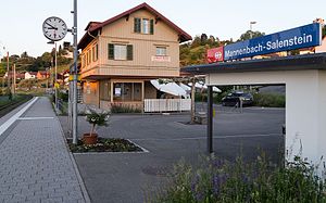
Mannenbach-Salenstein railway station
Distance: Approx. 1991 meters
Latitude and longitude: 47.66722222,9.05861111
Mannenbach-Salenstein railway station (German: Bahnhof Mannenbach-Salenstein) is a railway station in Salenstein, in the Swiss canton of Thurgau. It is an intermediate stop on the Lake line and is served as a request stop by local trains only.

Ermatingen railway station
Distance: Approx. 781 meters
Latitude and longitude: 47.66388889,9.08444444
Ermatingen railway station (German: Bahnhof Ermatingen) is a railway station in Ermatingen, in the Swiss canton of Thurgau. It is an intermediate stop on the Lake line and is served as a request stop by local trains only.

Triboltingen railway station
Distance: Approx. 2018 meters
Latitude and longitude: 47.66290111,9.10875
Triboltingen railway station (German: Bahnhof Triboltingen) is a railway station in the village of Triboltingen, part of the municipality of Ermatingen, in the Swiss canton of Thurgau. It is an intermediate stop on the Lake line and is served as a request stop by local trains only.
Weather in this IP's area
clear sky
16 Celsius
16 Celsius
15 Celsius
17 Celsius
1020 hPa
90 %
1020 hPa
973 hPa
10000 meters
0.79 m/s
0.78 m/s
65 degree
3 %
05:58:39
21:01:20