Country:
 Switzerland
Region:
City:
Latitude and Longitude:
Time Zone:
Postal Code:
IP information under different IP Channel
ip-api
Country
Region
City
ASN
Time Zone
ISP
Blacklist
Proxy
Latitude
Longitude
Postal
Route
IPinfo
Country
Region
City
ASN
Time Zone
ISP
Blacklist
Proxy
Latitude
Longitude
Postal
Route
MaxMind
Country
Region
City
ASN
Time Zone
ISP
Blacklist
Proxy
Latitude
Longitude
Postal
Route
Luminati
Country
CHRegion
zh
City
dietikon
ASN
Time Zone
Europe/Zurich
ISP
green.ch AG
Latitude
Longitude
Postal
db-ip
Country
Region
City
ASN
Time Zone
ISP
Blacklist
Proxy
Latitude
Longitude
Postal
Route
ipdata
Country
Region
City
ASN
Time Zone
ISP
Blacklist
Proxy
Latitude
Longitude
Postal
Route
Popular places and events near this IP address

Thurgau
Canton of Switzerland
Distance: Approx. 3114 meters
Latitude and longitude: 47.58333333,9.06666667
Thurgau (German: [ˈtuːrɡaʊ] ; French: Thurgovie; Italian: Turgovia; Romansh: Turgovia), anglicized as Thurgovia, and formally as the Canton of Thurgau, is one of the 26 cantons forming the Swiss Confederation. It is composed of five districts. Its capital is Frauenfeld.

Weinfelden
Municipality in Thurgau, Switzerland
Distance: Approx. 4 meters
Latitude and longitude: 47.56666667,9.1
Weinfelden is a municipality in the canton of Thurgau in Switzerland. It is the capital of the district of the same name. Weinfelden is an old town, which was known during Roman times as Quivelda (Winis Feld).

Bussnang
Municipality in the canton of Thurgau, Switzerland
Distance: Approx. 3119 meters
Latitude and longitude: 47.55,9.06666667
Bussnang is a municipality in the district of Weinfelden in the canton of Thurgau in Switzerland.
Weinfelden District
District in Switzerland
Distance: Approx. 0 meters
Latitude and longitude: 47.5667,9.1
Weinfelden District is one of the five districts of the canton of Thurgau, Switzerland. It has a population of 56,677 (as of 31 December 2020). Its capital is the town of Weinfelden.

Amlikon
Village in northern Switzerland
Distance: Approx. 3316 meters
Latitude and longitude: 47.56972222,9.05608056
Amlikon is a village and former municipality in the canton of Thurgau, Switzerland.
Hünikon, Thurgau
Distance: Approx. 2926 meters
Latitude and longitude: 47.56027778,9.06222222
Hünikon is a village in the canton of Thurgau, Switzerland. It was first recorded in year 857 as Huninchova. Hünikon is in the former municipality Bissegg.

Bachtobel Castle
Distance: Approx. 1872 meters
Latitude and longitude: 47.582085,9.08994
Bachtobel Castle is a castle in the municipality of Weinfelden of the Canton of Thurgau in Switzerland. It is a Swiss heritage site of national significance.
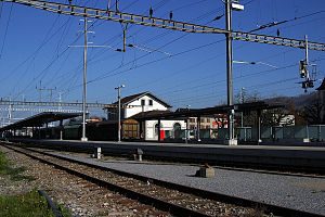
Weinfelden railway station
Railway station in Switzerland
Distance: Approx. 362 meters
Latitude and longitude: 47.566732,9.104823
Weinfelden railway station is a railway station in the Swiss canton of Thurgau and the municipality of Weinfelden. The station is located on the Winterthur–Romanshorn railway line, at its junctions with the Mittelthurgau-Bahn lines to Wil and Konstanz. Weinfelden station is an intermediate stop on long-distance services from Brig to Romanshorn and Lucerne to Konstanz.
Märstetten railway station
Distance: Approx. 3455 meters
Latitude and longitude: 47.583235,9.061065
Märstetten railway station is a railway station in the Swiss canton of Thurgau and the municipality of Märstetten. The station is located on the Winterthur–Romanshorn railway line. It is an intermediate stop on Zurich S-Bahn services S24 and S30.
Bürglen railway station
Distance: Approx. 3554 meters
Latitude and longitude: 47.55388889,9.14333333
Bürglen railway station (German: Bahnhof Bürglen) is a railway station in Bürglen, in the Swiss canton of Thurgau. It is an intermediate stop on the standard gauge Winterthur–Romanshorn line of Swiss Federal Railways.

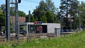
Oppikon railway station
Distance: Approx. 3297 meters
Latitude and longitude: 47.55194444,9.06194444
Oppikon railway station (German: Bahnhof Oppikon) is a railway station in the municipality of Bussnang, in the Swiss canton of Thurgau. It is an intermediate stop on the standard gauge Wil–Kreuzlingen line of THURBO, and is served as a request stop by local trains only.

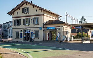
Bussnang railway station
Distance: Approx. 1689 meters
Latitude and longitude: 47.55611111,9.08388889
Bussnang railway station (German: Bahnhof Bussnang) is a railway station in the municipality of Bussnang, in the Swiss canton of Thurgau. It is an intermediate stop on the standard gauge Wil–Kreuzlingen line of THURBO, and is served as a request stop by local trains only.
Weather in this IP's area
clear sky
16 Celsius
16 Celsius
15 Celsius
19 Celsius
1020 hPa
88 %
1020 hPa
970 hPa
10000 meters
0.88 m/s
1.03 m/s
80 degree
2 %
05:58:55
21:00:56