Country:
 Switzerland
Region:
City:
Latitude and Longitude:
Time Zone:
Postal Code:
IP information under different IP Channel
ip-api
Country
Region
City
ASN
Time Zone
ISP
Blacklist
Proxy
Latitude
Longitude
Postal
Route
IPinfo
Country
Region
City
ASN
Time Zone
ISP
Blacklist
Proxy
Latitude
Longitude
Postal
Route
MaxMind
Country
Region
City
ASN
Time Zone
ISP
Blacklist
Proxy
Latitude
Longitude
Postal
Route
Luminati
Country
CHRegion
zh
City
dietikon
ASN
Time Zone
Europe/Zurich
ISP
green.ch AG
Latitude
Longitude
Postal
db-ip
Country
Region
City
ASN
Time Zone
ISP
Blacklist
Proxy
Latitude
Longitude
Postal
Route
ipdata
Country
Region
City
ASN
Time Zone
ISP
Blacklist
Proxy
Latitude
Longitude
Postal
Route
Popular places and events near this IP address

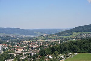
Lenzburg
Municipality in Aargau, Switzerland
Distance: Approx. 852 meters
Latitude and longitude: 47.38333333,8.18333333
Lenzburg is a town in the central region of the Swiss canton of Aargau and is the capital of the Lenzburg District. The town, founded in the Middle Ages, lies in the Seetal valley, about 3 kilometres south of the Aare river. Lenzburg and the neighbouring municipalities of Niederlenz and Staufen have grown together in an agglomeration.
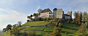
Lenzburg Castle
Castle in Lenzburg in the canton of Aargau, Switzerland
Distance: Approx. 800 meters
Latitude and longitude: 47.38738,8.18548
Lenzburg Castle (German: Schloss Lenzburg) is a castle located above the old part of the town of Lenzburg in the Canton of Aargau, Switzerland. It ranks among the oldest and most important of Switzerland. The castle stands on the almost circular castle hill (altitude: 504 m), which rises approximately 100 m (330 ft) over the surrounding plain but is only about 250 m (820 ft) in diameter.
Lenzburg District
District in Switzerland
Distance: Approx. 852 meters
Latitude and longitude: 47.38333333,8.16666667
Lenzburg District is a district of the Canton of Aargau in Switzerland, lying at the center of the canton. The district capital is the town of Lenzburg. It has a population of 65,707 (as of 31 December 2020).

Ammerswil
Municipality in Aargau, Switzerland
Distance: Approx. 3075 meters
Latitude and longitude: 47.36666667,8.2
Ammerswil is a municipality in the district of Lenzburg in the canton of Aargau in Switzerland. It is located 3 km (2 mi) southeast of the town of Lenzburg.
Niederlenz
Municipality in Aargau, Switzerland
Distance: Approx. 1426 meters
Latitude and longitude: 47.4,8.18333333
Niederlenz is a municipality in the district of Lenzburg in the canton of Aargau in Switzerland.

Schafisheim
Municipality in Aargau, Switzerland
Distance: Approx. 1970 meters
Latitude and longitude: 47.38333333,8.15
Schafisheim is a municipality in the district of Lenzburg in the canton of Aargau in Switzerland.
Staufen, Aargau
Municipality in Aargau, Switzerland
Distance: Approx. 852 meters
Latitude and longitude: 47.38333333,8.16666667
Staufen is a municipality in the district of Lenzburg in the canton of Aargau in Switzerland.

Lenzburg railway station
Distance: Approx. 460 meters
Latitude and longitude: 47.39118889,8.17036944
Lenzburg railway station (German: Bahnhof Lenzburg) is a railway station in the municipality of Lenzburg in the Swiss canton of Aargau. The station is located on the Heitersberg line, part of the Zurich to Olten main line, to the west of the junction with the Rupperswil–Immensee line and to the east of the junction with the Zofingen–Wettingen line. The Seetal line, which, despite being a standard gauge Swiss Federal Railways line, retains some characteristics of a roadside tramway, terminates at a platform across the street from the main station.

Hendschiken railway station
Distance: Approx. 2952 meters
Latitude and longitude: 47.38305556,8.21333333
Hendschiken railway station (German: Bahnhof Hendschiken) is a railway station in the municipality of Hendschiken, in the Swiss canton of Aargau. It is located at the junction of the standard gauge Brugg–Hendschiken and Rupperswil–Immensee lines of Swiss Federal Railways.

Stapferhaus
Museum in Switzerland
Distance: Approx. 443 meters
Latitude and longitude: 47.39053,8.16994
The Stapferhaus in Lenzburg, Switzerland, was founded in 1960 as a place for encounters and intellectual debate.

Müllerhaus Lenzburg
Building in Aargau, Switzerland
Distance: Approx. 267 meters
Latitude and longitude: 47.38611111,8.17527778
The Müllerhaus is a listed townhouse in Lenzburg, Aargau, Switzerland. The early classicist building, which was commissioned by the Lenzburg cotton industrialist Gottlieb Hünerwadel and built in 1785 by the Bernese architect Carl Ahasver von Sinner, is considered one of the most important cultural assets in Lenzburg.

Aargauer Literaturhaus
Cultural institution in Lenzburg (Switzerland)
Distance: Approx. 267 meters
Latitude and longitude: 47.38611111,8.17527778
The Aargauer Literaturhaus (English: Aargau Literature House) is a cultural institution in Lenzburg (Canton of Aargau, Switzerland) dedicated to the popularization of literature and literary practices. It carries out author talks, reading conferences, and literary workshops for all ages on a regular basis. Established in 2004, it is located in the city's cultural center, the Müllerhaus, an architectural monument of the 18th century and one of the most important cultural assets in Lenzburg.
Weather in this IP's area
few clouds
18 Celsius
18 Celsius
16 Celsius
19 Celsius
1019 hPa
90 %
1019 hPa
972 hPa
10000 meters
0.96 m/s
0.96 m/s
80 degree
13 %
06:03:13
21:04:03