Country:
 Switzerland
Region:
City:
Latitude and Longitude:
Time Zone:
Postal Code:
IP information under different IP Channel
ip-api
Country
Region
City
ASN
Time Zone
ISP
Blacklist
Proxy
Latitude
Longitude
Postal
Route
IPinfo
Country
Region
City
ASN
Time Zone
ISP
Blacklist
Proxy
Latitude
Longitude
Postal
Route
MaxMind
Country
Region
City
ASN
Time Zone
ISP
Blacklist
Proxy
Latitude
Longitude
Postal
Route
Luminati
Country
CHRegion
zh
City
dietikon
ASN
Time Zone
Europe/Zurich
ISP
green.ch AG
Latitude
Longitude
Postal
db-ip
Country
Region
City
ASN
Time Zone
ISP
Blacklist
Proxy
Latitude
Longitude
Postal
Route
ipdata
Country
Region
City
ASN
Time Zone
ISP
Blacklist
Proxy
Latitude
Longitude
Postal
Route
Popular places and events near this IP address

Battle of Sempach
Part of the expansion of the Swiss Confederation
Distance: Approx. 2116 meters
Latitude and longitude: 47.14555556,8.21333333
The Battle of Sempach was fought on 9 July 1386, between Leopold III, Duke of Austria and the Old Swiss Confederacy. The battle was a decisive Swiss victory in which Duke Leopold and numerous Austrian nobles died. The victory helped turn the loosely allied Swiss Confederation into a more unified nation and is seen as a turning point in the growth of Switzerland.

Sempach
Municipality in Lucerne, Switzerland
Distance: Approx. 489 meters
Latitude and longitude: 47.13333333,8.2
Sempach is a municipality in the district of Sursee in the canton of Lucerne in Switzerland.

Rain, Lucerne
Municipality in Lucerne, Switzerland
Distance: Approx. 4252 meters
Latitude and longitude: 47.13333333,8.25
Rain is a municipality in the district of Hochdorf in the canton of Lucerne in Switzerland.
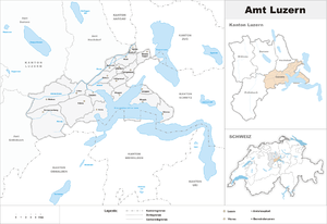
Lucerne District
District in Switzerland
Distance: Approx. 4385 meters
Latitude and longitude: 47.16666667,8.16666667
Lucerne District (German: Luzern) is a former Amt (administrative district) of the Canton of Lucerne, Switzerland. It had a population of 176,710 (as of 2013) and consisted of 18 municipalities, of which the city of Lucerne is the largest and the district capital. On 1 January 2013 the Amt was divided into two Wahlkreis, Lucerne-Stadt and Lucerne-Land.

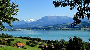
Lake Sempach
Distance: Approx. 3490 meters
Latitude and longitude: 47.144445,8.15166667
Lake Sempach (German: Sempachersee) is a lake in the canton of Lucerne, Switzerland. Its area is about 14.5 km2 (5.6 sq mi) and its maximum depth is 87 m (285 ft). A 50-metre-large (160 ft) island named Gamma Insel is located east of Sursee.
Eich, Switzerland
Municipality in Lucerne, Switzerland
Distance: Approx. 2883 meters
Latitude and longitude: 47.15,8.16666667
Eich is a municipality in the district of Sursee in the canton of Lucerne in Switzerland.
Hildisrieden
Municipality in Lucerne, Switzerland
Distance: Approx. 3602 meters
Latitude and longitude: 47.15,8.23333333
Hildisrieden is a municipality in the district of Sursee in the canton of Lucerne in Switzerland.
Neuenkirch
Municipality in Lucerne, Switzerland
Distance: Approx. 3581 meters
Latitude and longitude: 47.1,8.2
Neuenkirch is a municipality in the district of Sursee in the canton of Lucerne in Switzerland.
Steinibühlweiher
Reservoir in Sempach, Canton of Lucerne
Distance: Approx. 1295 meters
Latitude and longitude: 47.1375,8.20888889
Steinibühlweiher is a pond at Sempach in the Canton of Lucerne, Switzerland. The artificial reservoir has a surface area of 3 ha.

Schlachtkapelle
Distance: Approx. 2104 meters
Latitude and longitude: 47.14611111,8.21222222
Schlachtkapelle (lit. "battle chapel") is a term used in Switzerland for a chapel dedicated to the memory of one of the battles of the Old Swiss Confederacy. Schlachtkapellen in Switzerland include those commemorating: the battle of Morgarten (1315), the battle of Sempach (1386), the battle of Näfels (1388), the battle of Stoss (1405), the battle of Dornach (1499), among others.
Lucerne-Land District
District in Switzerland
Distance: Approx. 4385 meters
Latitude and longitude: 47.16666667,8.16666667
Lucerne-Land District (German: Wahlkreis Luzern-Land) is one of the two new Wahlkreis formed from the former Lucerne Amt in 2013 in the Canton of Lucerne, Switzerland. It has a population of 104,751 (as of 31 December 2020) and includes everything but the city of Lucerne from the old Amt.

Sempach-Neuenkirch railway station
Swiss railway station
Distance: Approx. 2146 meters
Latitude and longitude: 47.11277778,8.1975
Sempach-Neuenkirch railway station (German: Bahnhof Sempach-Neuenkirch) is a railway station in the municipality of Neuenkirch, in the Swiss canton of Lucerne. It is an intermediate stop on the standard gauge Olten–Lucerne line of Swiss Federal Railways.
Weather in this IP's area
clear sky
17 Celsius
17 Celsius
15 Celsius
18 Celsius
1019 hPa
94 %
1019 hPa
959 hPa
10000 meters
0.45 m/s
0.89 m/s
185 degree
9 %
06:03:58
21:03:09