Country:
 Switzerland
Region:
City:
Latitude and Longitude:
Time Zone:
Postal Code:
IP information under different IP Channel
ip-api
Country
Region
City
ASN
Time Zone
ISP
Blacklist
Proxy
Latitude
Longitude
Postal
Route
IPinfo
Country
Region
City
ASN
Time Zone
ISP
Blacklist
Proxy
Latitude
Longitude
Postal
Route
MaxMind
Country
Region
City
ASN
Time Zone
ISP
Blacklist
Proxy
Latitude
Longitude
Postal
Route
Luminati
Country
CHRegion
zh
City
dietikon
ASN
Time Zone
Europe/Zurich
ISP
green.ch AG
Latitude
Longitude
Postal
db-ip
Country
Region
City
ASN
Time Zone
ISP
Blacklist
Proxy
Latitude
Longitude
Postal
Route
ipdata
Country
Region
City
ASN
Time Zone
ISP
Blacklist
Proxy
Latitude
Longitude
Postal
Route
Popular places and events near this IP address

Cham, Switzerland
Municipality in Zug, Switzerland
Distance: Approx. 1038 meters
Latitude and longitude: 47.18333333,8.45
Cham is a municipality in the canton of Zug in Switzerland.
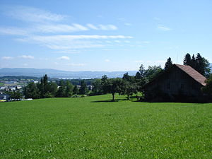
Hünenberg
Municipality in Zug, Switzerland
Distance: Approx. 2294 meters
Latitude and longitude: 47.18333333,8.43333333
Hünenberg is a municipality in the canton of Zug in Switzerland.
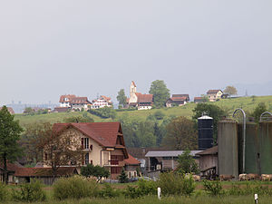
Steinhausen, Switzerland
Municipality in Zug, Switzerland
Distance: Approx. 2490 meters
Latitude and longitude: 47.2,8.48333333
Steinhausen is a city in the canton of Zug in Switzerland.

St. Andreas Castle
Distance: Approx. 423 meters
Latitude and longitude: 47.17875,8.46625
St. Andreas Castle (German: Schloss St. Andreas) is a privately owned castle located in Cham, in the Canton of Zug, Switzerland.
International School of Central Switzerland
Private international school in Cham, Canton of Zug, Switzerland
Distance: Approx. 1263 meters
Latitude and longitude: 47.1913892,8.4540218
The International School of Central Switzerland (ISCS) is a private international school in Cham, Canton of Zug, Switzerland. It serves students aged 3 to 18 in Kindergarten through Year 13 and is a Cambridge International School.
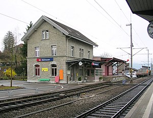
Steinhausen railway station
Distance: Approx. 1764 meters
Latitude and longitude: 47.194459,8.478184
Steinhausen is a railway station in the Swiss canton of Zug, situated in the municipality of Steinhausen. The station is located on the Zurich to Zug via Affoltern am Albis railway line and is an intermediate stop on Zurich S-Bahn line S5.

Steinhausen Rigiblick railway station
Distance: Approx. 1385 meters
Latitude and longitude: 47.18805,8.47967
Steinhausen-Rigiblick is a railway station in the Swiss canton of Zug, in the municipality of Steinhausen, on the Zurich to Zug via Affoltern am Albis railway line. It was inaugurated on 26 November 2012 and opened on the timetable change on 9 December 2012. The construction of the 320-metre-long station cost about CHF 10.5 million.

Hünenberg Chämleten railway station
Swiss railway station
Distance: Approx. 1774 meters
Latitude and longitude: 47.16915889,8.44990806
Hünenberg Chämleten railway station (German: Bahnhof Hünenberg Chämleten) is a railway station in the municipality of Hünenberg, in the Swiss canton of Zug. It is an intermediate stop on the standard gauge Zug–Lucerne line of Swiss Federal Railways.

Hünenberg Zythus railway station
Swiss railway station
Distance: Approx. 1392 meters
Latitude and longitude: 47.17360806,8.450095
Hünenberg Zythus railway station (German: Bahnhof Hünenberg Zythus) is a railway station in the municipality of Hünenberg, in the Swiss canton of Zug. It is an intermediate stop on the standard gauge Zug–Lucerne line of Swiss Federal Railways.

Cham railway station (Switzerland)
Swiss railway station
Distance: Approx. 630 meters
Latitude and longitude: 47.17824389,8.457505
Cham railway station (German: Bahnhof Cham) is a railway station in the municipality of Cham, in the Swiss canton of Zug. It is an intermediate stop on the standard gauge Zug–Lucerne line of Swiss Federal Railways.

Cham Alpenblick railway station
Swiss railway station
Distance: Approx. 595 meters
Latitude and longitude: 47.18228194,8.47146306
Cham Alpenblick railway station (German: Bahnhof Cham Alpenblick) is a railway station in the municipality of Cham, in the Swiss canton of Zug. It is an intermediate stop on the standard gauge Zug–Lucerne line of Swiss Federal Railways.

Zug Chollermüli railway station
Swiss railway station
Distance: Approx. 1756 meters
Latitude and longitude: 47.18023806,8.48664611
Zug Chollermüli railway station (German: Bahnhof Zug Chollermüli) is a railway station in the municipality of Zug, in the Swiss canton of Zug. It is located at the junction of the standard gauge Zug–Lucerne and Zürich–Zug lines of Swiss Federal Railways, although no trains on the latter stop here. In the past, the station Kollermühle had been at this location (1902 to 1966).
Weather in this IP's area
clear sky
18 Celsius
18 Celsius
16 Celsius
19 Celsius
1019 hPa
91 %
1019 hPa
970 hPa
10000 meters
5 %
06:02:43
21:02:14