Country:
 Switzerland
Region:
City:
Latitude and Longitude:
Time Zone:
Postal Code:
IP information under different IP Channel
ip-api
Country
Region
City
ASN
Time Zone
ISP
Blacklist
Proxy
Latitude
Longitude
Postal
Route
IPinfo
Country
Region
City
ASN
Time Zone
ISP
Blacklist
Proxy
Latitude
Longitude
Postal
Route
MaxMind
Country
Region
City
ASN
Time Zone
ISP
Blacklist
Proxy
Latitude
Longitude
Postal
Route
Luminati
Country
CHRegion
zh
City
dietikon
ASN
Time Zone
Europe/Zurich
ISP
green.ch AG
Latitude
Longitude
Postal
db-ip
Country
Region
City
ASN
Time Zone
ISP
Blacklist
Proxy
Latitude
Longitude
Postal
Route
ipdata
Country
Region
City
ASN
Time Zone
ISP
Blacklist
Proxy
Latitude
Longitude
Postal
Route
Popular places and events near this IP address

Bättwil
Municipality in Solothurn, Switzerland
Distance: Approx. 2728 meters
Latitude and longitude: 47.5,7.51666667
Bättwil (German pronunciation: [ˈbɛtˌviːl]) is a municipality in the district of Dorneck in the canton of Solothurn in Switzerland.
Hofstetten-Flüh
Municipality in Solothurn, Switzerland
Distance: Approx. 3374 meters
Latitude and longitude: 47.48333333,7.51666667
Hofstetten-Flüh (Swiss German: Hufstette-Flüe) is a municipality in the district of Dorneck in the canton of Solothurn in Switzerland.

Witterswil
Municipality in Solothurn, Switzerland
Distance: Approx. 3374 meters
Latitude and longitude: 47.48333333,7.51666667
Witterswil (Swiss German: Witterschwyl) is a municipality in the district of Dorneck in the canton of Solothurn in Switzerland.
Reinach, Basel-Landschaft
Municipality in Basel-Landschaft, Switzerland
Distance: Approx. 3032 meters
Latitude and longitude: 47.48333333,7.58333333
Reinach (Swiss German: Rynach) is a municipality in the district Arlesheim in the canton of Basel-Country in Switzerland.

Ettingen
Municipality in Basel-Landschaft, Switzerland
Distance: Approx. 2001 meters
Latitude and longitude: 47.48333333,7.55
Ettingen (Swiss German: Ettige) is a municipality in the district of Arlesheim in the canton of Basel-Country in Switzerland.

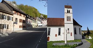
Therwil
Municipality in Basel-Landschaft, Switzerland
Distance: Approx. 256 meters
Latitude and longitude: 47.5,7.55
Therwil (Swiss German: Därwyl) is a municipality in the district of Arlesheim in the canton of Basel-Country in Switzerland.

Biel-Benken
Municipality in Basel-Landschaft, Switzerland
Distance: Approx. 2728 meters
Latitude and longitude: 47.5,7.51666667
Biel-Benken (Swiss German: Biel-Bängge) is a municipality in the district of Arlesheim in the canton of Basel-Country in Switzerland.

Bottmingen
Municipality in Basel-Landschaft, Switzerland
Distance: Approx. 2009 meters
Latitude and longitude: 47.51666667,7.56666667
Bottmingen (Swiss German: Bottmige) is a municipality in the district of Arlesheim in the canton of Basel-Land in Switzerland.

Oberwil, Basel-Landschaft
Municipality in Basel-Landschaft, Switzerland
Distance: Approx. 1735 meters
Latitude and longitude: 47.51666667,7.55
Oberwil (German pronunciation: [ˈoːbɐˌviːl]) is a municipality in the district of Arlesheim in the canton of Basel-Country in Switzerland.

Battle of Bruderholz
Battle during the Swabian War
Distance: Approx. 3222 meters
Latitude and longitude: 47.5075,7.59472222
The Battle of Bruderholz took place on 22 March 1499 in the Swabian War between Swabian troops and forces of the Old Swiss Confederacy. The Swabians had raided several Swiss villages and were on their way back when they met troops from Lucerne, Solothurn, and Bern, who also came back from a raid in the Alsace. Anticipating the likely route of the Swabian troops, the Swiss soldiers concealed themselves in the woods at Bruderholz hill, near Basel.

1356 Basel earthquake
6.0–7.1 Mw earthquake in Switzerland
Distance: Approx. 3545 meters
Latitude and longitude: 47.5,7.6
The 1356 Basel earthquake is the most significant seismological event to have occurred in Central Europe in recorded history and had a moment magnitude in the range of 6.0–7.1. This earthquake, which occurred on 18 October 1356, is also known as the Sankt-Lukas-Tag Erdbeben (English: Earthquake of Saint Luke), as 18 October is the feast day of Saint Luke the Evangelist.
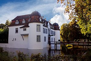
Bottmingen Castle
Castle in Bottminger, Switzerland
Distance: Approx. 2816 meters
Latitude and longitude: 47.52361111,7.57027778
Bottmingen Castle (German: Schloss Bottmingen) is a castle in the municipality of Bottmingen in the canton of Basel-Land in Switzerland. It is a Swiss heritage site of national significance.
Weather in this IP's area
clear sky
18 Celsius
18 Celsius
16 Celsius
20 Celsius
1018 hPa
83 %
1018 hPa
983 hPa
10000 meters
1.84 m/s
1.75 m/s
130 degree
10 %
06:05:20
21:06:54