Country:
 Switzerland
Region:
City:
Latitude and Longitude:
Time Zone:
Postal Code:
IP information under different IP Channel
ip-api
Country
Region
City
ASN
Time Zone
ISP
Blacklist
Proxy
Latitude
Longitude
Postal
Route
IPinfo
Country
Region
City
ASN
Time Zone
ISP
Blacklist
Proxy
Latitude
Longitude
Postal
Route
MaxMind
Country
Region
City
ASN
Time Zone
ISP
Blacklist
Proxy
Latitude
Longitude
Postal
Route
Luminati
Country
CHRegion
zh
City
dietikon
ASN
Time Zone
Europe/Zurich
ISP
green.ch AG
Latitude
Longitude
Postal
db-ip
Country
Region
City
ASN
Time Zone
ISP
Blacklist
Proxy
Latitude
Longitude
Postal
Route
ipdata
Country
Region
City
ASN
Time Zone
ISP
Blacklist
Proxy
Latitude
Longitude
Postal
Route
Popular places and events near this IP address
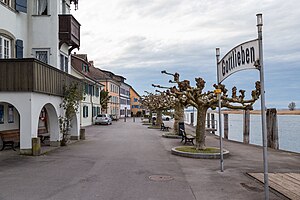
Gottlieben
Municipality in Thurgau, Switzerland
Distance: Approx. 282 meters
Latitude and longitude: 47.66666667,9.13333333
Gottlieben is a municipality in the district of Kreuzlingen in the canton of Thurgau in Switzerland.

Tägerwilen
Municipality in Thurgau, Switzerland
Distance: Approx. 1582 meters
Latitude and longitude: 47.65,9.13333333
Tägerwilen is a municipality in the district of Kreuzlingen in the canton of Thurgau in Switzerland.

Triboltingen
Municipality in Thurgau, Switzerland
Distance: Approx. 1678 meters
Latitude and longitude: 47.66,9.111
Triboltingen is a small village in the canton of Thurgau in Switzerland, situated on the south shore of the Untersee part of Lake Constance. Since 1975, it is politically part of Ermatingen. Triboltingen railway station on the Lake Line is served by the S1 of St.

Gottlieben Castle
Building in Gottlieben, Switzerland
Distance: Approx. 265 meters
Latitude and longitude: 47.664027,9.136021
Gottlieben Castle (German: Schloss Gottlieben) is a castle in the municipality of Gottlieben in the canton of Thurgau in Switzerland. It is a Swiss heritage site of national significance.
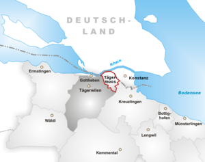
Tägermoos
Place in Thurgau, Switzerland
Distance: Approx. 1393 meters
Latitude and longitude: 47.66,9.15
The Tägermoos is an area of 1.54 km2 (380 acres) in Thurgau, Switzerland, wedged between the outskirts of the German city of Constance and the core village of the Swiss municipality of Tägerwilen. It lies on the south bank of the Seerhein. In the east, it borders the district Paradies of Constance.

Triboldingerbohl
Distance: Approx. 1119 meters
Latitude and longitude: 47.67166667,9.1225
Triboldingerbohl, also known as Triboltingen or großes Bohl or Langenrain, is the fourth largest island of Lake Constance, with an area of 0.13557 square kilometres (0.05234 sq mi). It is 780 meters (2,560 ft) long and up to 230 meters (750 ft) wide. It is located in the easternmost part of the Untersee (Lake Constance), near the point where the Seerhein flows into the lake.

Castell Castle
Distance: Approx. 2068 meters
Latitude and longitude: 47.645628,9.133143
Castell Castle is a castle in the municipality of Tägerwilen of the Canton of Thurgau in Switzerland. It is a Swiss heritage site of national significance. East of the present-day castle can be found the ruins of the 12th-century Castell Castle, one of the largest defensive structures from the medieval period in the Lake Constance area.

Wollmatinger Ried
Distance: Approx. 1402 meters
Latitude and longitude: 47.67638889,9.12777778
The nature reserve of Wollmatinger Ried – Untersee – Gnadensee is a protected area on the shores of Lake Constance in Germany. It has an area of 767 hectares and is the largest and most important nature reserve on the German side of Lake Constance. It is rich in plant and animal species and extends from the banks of the Seerhein river west of Constance via the causeway to the Island of Reichenau in the Untersee to the eastern Gnadensee near Allensbach-Hegne.
Entlibühl
Distance: Approx. 1216 meters
Latitude and longitude: 47.66586111,9.11647222
Entlibühl or Äntebüel, formerly also Koschmannskeller Kopf was a small island in the Untersee, itself part of Lake Constance. It lay around 30 metres off the Swiss shore below Gottlieben in the Canton of Thurgau. The island is shown on historical maps by the Swisstopo from 1966 to 1995 off the western boundary of the municipality of Gottlieben with its former neighbour, Triboltingen (1975 incorporated into Ermatingen).

Triboltingen railway station
Distance: Approx. 1786 meters
Latitude and longitude: 47.66290111,9.10875
Triboltingen railway station (German: Bahnhof Triboltingen) is a railway station in the village of Triboltingen, part of the municipality of Ermatingen, in the Swiss canton of Thurgau. It is an intermediate stop on the Lake line and is served as a request stop by local trains only.

Tägerwilen-Gottlieben railway station
Distance: Approx. 511 meters
Latitude and longitude: 47.65961694,9.13295889
Tägerwilen-Gottlieben railway station (German: Bahnhof Tägerwilen-Gottlieben) is a railway station in Tägerwilen, in the Swiss canton of Thurgau. It is an intermediate stop on the Lake line and is served as a request stop by local trains only. It is one of two stations within the municipality of Tägerwilen; the other, Tägerwilen Dorf, is located 950 metres (3,120 ft) away on the Wil–Kreuzlingen line.

Tägerwilen Dorf railway station
Distance: Approx. 1278 meters
Latitude and longitude: 47.65388889,9.14
Tägerwilen Dorf railway station (German: Bahnhof Tägerwilen Dorf) is a railway station in the municipality of Tägerwilen, in the Swiss canton of Thurgau. It is an intermediate stop on the standard gauge Wil–Kreuzlingen line of THURBO, and is served as a request stop by local trains only. It is one of two stations within the municipality of Tägerwilen; the other, Tägerwilen-Gottlieben, is located 950 metres (3,120 ft) away on the Lake line.
Weather in this IP's area
clear sky
16 Celsius
16 Celsius
15 Celsius
17 Celsius
1020 hPa
90 %
1020 hPa
973 hPa
10000 meters
0.45 m/s
0.89 m/s
2 %
05:58:28
21:01:08