Country:
 Switzerland
Region:
City:
Latitude and Longitude:
Time Zone:
Postal Code:
IP information under different IP Channel
ip-api
Country
Region
City
ASN
Time Zone
ISP
Blacklist
Proxy
Latitude
Longitude
Postal
Route
IPinfo
Country
Region
City
ASN
Time Zone
ISP
Blacklist
Proxy
Latitude
Longitude
Postal
Route
MaxMind
Country
Region
City
ASN
Time Zone
ISP
Blacklist
Proxy
Latitude
Longitude
Postal
Route
Luminati
Country
CHRegion
zh
City
dietikon
ASN
Time Zone
Europe/Zurich
ISP
green.ch AG
Latitude
Longitude
Postal
db-ip
Country
Region
City
ASN
Time Zone
ISP
Blacklist
Proxy
Latitude
Longitude
Postal
Route
ipdata
Country
Region
City
ASN
Time Zone
ISP
Blacklist
Proxy
Latitude
Longitude
Postal
Route
Popular places and events near this IP address
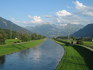
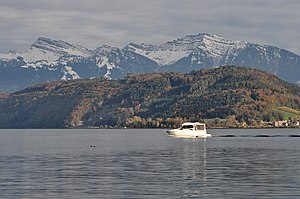
Linth
River in Switzerland
Distance: Approx. 2795 meters
Latitude and longitude: 47.2183,8.9407
The Linth (pronounced [ˈlɪnt] "lint") is a Swiss river that rises near the village of Linthal in the mountains of the canton of Glarus, and eventually flows into the Obersee section of Lake Zurich. It is about 50 kilometres (31 mi) in length. The water power of the Linth was a main factor in the creation of the textile industry of the canton Glarus, and is today used to drive the Linth–Limmern power stations in its upper reaches.

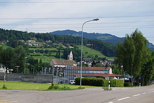
Schmerikon
Municipality in St. Gallen, Switzerland
Distance: Approx. 2264 meters
Latitude and longitude: 47.23333333,8.95
Schmerikon is a municipality in the Wahlkreis (constituency) of See-Gaster in the canton of St. Gallen in Switzerland. In the local Swiss German dialect it is called Schmerike.

Goldingen
Former municipality in St. Gallen, Switzerland
Distance: Approx. 4532 meters
Latitude and longitude: 47.26666667,8.96666667
Goldingen is a former municipality in the Wahlkreis (constituency) of See-Gaster in the canton of St. Gallen in Switzerland. On 1 January 2013 the former municipalities of Goldingen and St.

Tuggen
Municipality in Schwyz, Switzerland
Distance: Approx. 4518 meters
Latitude and longitude: 47.2,8.93333333
Tuggen is a municipality in March District in the canton of Schwyz in Switzerland.
Berg, St. Gallen
Municipality in St. Gallen, Switzerland
Distance: Approx. 2784 meters
Latitude and longitude: 47.24166667,8.95833333
Berg is a municipality in the Wahlkreis (constituency) of Rorschach in the canton of St. Gallen in Switzerland.
Eschenbach, St. Gallen
Municipality in St. Gallen, Switzerland
Distance: Approx. 811 meters
Latitude and longitude: 47.23333333,8.91666667
Eschenbach is a municipality in the Wahlkreis (constituency) of See-Gaster in the canton of St. Gallen in Switzerland. On 1 January 2013 the former municipalities of Goldingen and St.
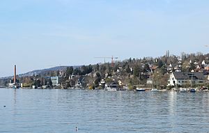
Goldbach, Zurich
Distance: Approx. 3912 meters
Latitude and longitude: 47.2679,8.8905
Goldbach is part of the municipality of Küsnacht in the district of Meilen in the canton of Zürich in Switzerland. Goldbach is located north of Küsnacht proper, south and west of Zollikon, and on the Goldküste (Gold Coast) of Lake Zürich. The Küsnacht-Goldbach railway station is 12–14 minutes from downtown Zurich via the S6 and S16 S-Bahn train lines.
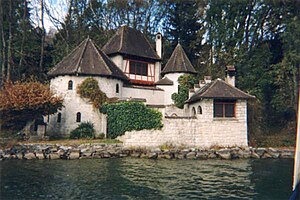
Bollingen Tower
House built by psychiatrist Carl Jung
Distance: Approx. 2427 meters
Latitude and longitude: 47.2211,8.9051
The Bollingen Tower is a structure built by Swiss psychiatrist Carl Jung. In appearance, it is a small castle with four towers. It is located in the village of Bollingen on the shore of the Obersee (upper lake) basin of Lake Zürich.
Wald railway station
Distance: Approx. 3673 meters
Latitude and longitude: 47.272372,8.913871
Wald railway station is a railway station in the Swiss canton of Zürich, situated in the municipality of Wald.

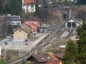
Schmerikon railway station
Distance: Approx. 2317 meters
Latitude and longitude: 47.22516,8.94338194
Schmerikon railway station (German: Bahnhof Schmerikon) is a railway station situated in the municipality of Schmerikon in the Swiss canton of St. Gallen. It is located next to the shore of Obersee on the Rapperswil to Ziegelbrücke line.
Buechberg
Hill in the Swiss cantons of Schwyz and St. Gallen
Distance: Approx. 4383 meters
Latitude and longitude: 47.20138889,8.90888889
Buechberg (also Buchberg) is an elongated molasse hill in the Swiss cantons of Schwyz and St. Gallen on Obersee lakeshore.

Bollingen railway station
Disused railway station in Switzerland
Distance: Approx. 4058 meters
Latitude and longitude: 47.21741667,8.87922222
Bollingen railway station (German: Bahnhof Bollingen) was until 2004 a railway station in the municipality of Rapperswil-Jona (former Jona municipality) in the canton of St. Gallen, Switzerland. It is located about 1 km (0.62 mi) west of the village of Bollingen on the Rapperswil–Ziegelbrücke railway line, between Blumenau and Schmerikon.
Weather in this IP's area
clear sky
17 Celsius
17 Celsius
16 Celsius
20 Celsius
1020 hPa
77 %
1020 hPa
963 hPa
10000 meters
1.41 m/s
1.32 m/s
139 degree
3 %
06:00:42
21:00:35