Country:
 Iceland
Region:
City:
Latitude and Longitude:
Time Zone:
Postal Code:
IP information under different IP Channel
ip-api
Country
Region
City
ASN
Time Zone
ISP
Blacklist
Proxy
Latitude
Longitude
Postal
Route
IPinfo
Country
Region
City
ASN
Time Zone
ISP
Blacklist
Proxy
Latitude
Longitude
Postal
Route
MaxMind
Country
Region
City
ASN
Time Zone
ISP
Blacklist
Proxy
Latitude
Longitude
Postal
Route
Luminati
Country
ISRegion
1
City
hafnarfjordur
ASN
Time Zone
Atlantic/Reykjavik
ISP
Ljosleidarinn ehf
Latitude
Longitude
Postal
db-ip
Country
Region
City
ASN
Time Zone
ISP
Blacklist
Proxy
Latitude
Longitude
Postal
Route
ipdata
Country
Region
City
ASN
Time Zone
ISP
Blacklist
Proxy
Latitude
Longitude
Postal
Route
Popular places and events near this IP address

Vestmannaeyjar
Town and municipality in South Constituency, Iceland
Distance: Approx. 2940 meters
Latitude and longitude: 63.41666667,-20.28333333
Vestmannaeyjar (Icelandic pronunciation: [ˈvɛstˌmanːaˌeiːjar̥] , sometimes anglicized as Westman Islands) is a municipality and archipelago off the south coast of Iceland. The largest island, Heimaey, has a population of 4,414, most of whom live in the archipelago's main town, Vestmannaeyjabær. The other islands are uninhabited, although six have single hunting cabins.

Heimaey
Island in iceland
Distance: Approx. 1095 meters
Latitude and longitude: 63.43333333,-20.26666667
Heimaey (Icelandic pronunciation: [ˈheiːmaˌeiː] ), is an Icelandic island. At 13.4 square kilometres (5.2 sq mi), it is the largest island in the Vestmannaeyjar archipelago, and the largest and most populated island off the Icelandic coast. Heimaey is 4 nautical miles (7.4 km; 4.6 mi) off the south coast of Iceland.
Framhaldsskólinn í Vestmannaeyjum
Distance: Approx. 844 meters
Latitude and longitude: 63.43516667,-20.2715
Framhaldsskólinn í Vestmannaeyjum, the comprehensive secondary school of Vestmannaeyjar, Iceland, was founded 1979 when the mechanical engineering, common trades (is. iðnskóli) and the higher education department of the secondary school merged into one. Then in 1997, it also took over the school of maritime navigation.

Eldfell
Volcanic cone in Heimaey, Iceland
Distance: Approx. 1718 meters
Latitude and longitude: 63.4325,-20.2475
Eldfell is a volcanic cone just over 200 metres (660 ft) high on the Icelandic island of Heimaey. It formed in a volcanic eruption which began without warning on the eastern side of Heimaey, in the Westman Islands, on 23 January 1973. The name means Hill of Fire in Icelandic.
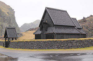
Heimaey stave church
Distance: Approx. 633 meters
Latitude and longitude: 63.4443,-20.2612
Heimaey Stave Church (Stafkirkjan) is a close replica of Haltdalen stave church situated in the Skansinn area of the harbour of Vestmannaeyjabær on Heimaey, Vestmannaeyjar, Iceland.

Hásteinsvöllur
Distance: Approx. 811 meters
Latitude and longitude: 63.43941389,-20.28795
Hásteinsvöllur (Icelandic pronunciation: [ˈhauːˌsteinsˌvœtlʏr̥]) is a multi-use stadium in Vestmannaeyjar, Iceland. It is located in the town of Vestmannaeyjar on the island of Heimaey. It is used mostly for football matches, and is the home ground of Íþróttabandalag Vestmannaeyja (ÍBV).

Helgafell (Vestmannaeyjabær)
Volcanic cone on Heimaey Island, Iceland
Distance: Approx. 1648 meters
Latitude and longitude: 63.42916667,-20.26
Helgafell (Icelandic pronunciation: [ˈhɛlkaˌfɛtl̥] , "Helgi's mountain") is an inactive 227 m (745 ft) volcanic cone located on the island of Heimaey in the Vestmannaeyjar archipelago in Iceland. The Stórhöfði peninsula immediately to the south of Helgafell in what is now southern Heimaey formed about 6000 years ago. Helgafell formed a thousand years later in a monogenetic volcanic eruption,: 55 which created much of the present island over a period of between 11 and 12 months, at 3950 BCE ± 300 years.

Bjarnarey
Distance: Approx. 4192 meters
Latitude and longitude: 63.448,-20.19
Bjarnarey (Icelandic pronunciation: [ˈpja(r)tnarˌeiː] ) is a small, uninhabited island in the Vestmann Islands, south of Iceland. It is one of the 18 islands that make up the Vestmannaeyjar archipelago.

Elliðaey
Island south of Iceland
Distance: Approx. 5503 meters
Latitude and longitude: 63.46527778,-20.175
Elliðaey (Icelandic pronunciation: [ˈɛtlɪːðaˌeiː] ; or Ellirey [ˈɛtlɪrˌeiː]) is a small, uninhabited island south of Iceland. It is the most northeastern of the Vestmannaeyjar (Westman Islands), an archipelago consisting of 15 to 18 islands and assorted smaller rocks.

Westman Islands Golf Club
Icelandic golf course
Distance: Approx. 1277 meters
Latitude and longitude: 63.438019,-20.296815
The Westman Island Golf Club is a golf club located on the Westman Islands (Vestmannaeyjar in Icelandic), on the island of Heimaey off the southern coast of Iceland. The club was established in 1938 as a nine-hole course and is the third oldest golf club in Iceland. The course was expanded to 18 holes in the early 1990s by Hannes Thorsteinsson.

Stórhöfði
Peninsula in Iceland
Distance: Approx. 4919 meters
Latitude and longitude: 63.399022,-20.288315
Stórhöfði (Icelandic pronunciation: [ˈstourˌhœvðɪ]) is a peninsula and the southernmost point of Heimaey, the largest island in the Vestmannaeyjar archipelago, in Iceland. It is claimed to be the windiest place in Europe, and holds the record for the lowest on land observation of air pressure in Europe. The name means great cape and was also the name of a street in Reykjavík's Höfði industrial area until 2015 when it was renamed Svarthöfði (black cape), which is the Icelandic term for Darth Vader.

Elephant Rock (Iceland)
Rock formation in Iceland
Distance: Approx. 1907 meters
Latitude and longitude: 63.4394,-20.311
Elephant Rock (Icelandic:Fíllinn) is a natural rock formation on the island of Heimaey, in the Westman Islands archipelago. It is made of basalt rock formed in a volcanic eruption of Eldfell. It is known for its shape which resembles the head of an elephant with its trunk in the water.
Weather in this IP's area
overcast clouds
11 Celsius
10 Celsius
11 Celsius
11 Celsius
999 hPa
85 %
999 hPa
999 hPa
10000 meters
7.56 m/s
8.67 m/s
282 degree
100 %
04:20:54
22:34:03