Country:
 Iceland
Region:
City:
Latitude and Longitude:
Time Zone:
Postal Code:
IP information under different IP Channel
ip-api
Country
Region
City
ASN
Time Zone
ISP
Blacklist
Proxy
Latitude
Longitude
Postal
Route
IPinfo
Country
Region
City
ASN
Time Zone
ISP
Blacklist
Proxy
Latitude
Longitude
Postal
Route
MaxMind
Country
Region
City
ASN
Time Zone
ISP
Blacklist
Proxy
Latitude
Longitude
Postal
Route
Luminati
Country
ISRegion
1
City
hafnarfjordur
ASN
Time Zone
Atlantic/Reykjavik
ISP
Ljosleidarinn ehf
Latitude
Longitude
Postal
db-ip
Country
Region
City
ASN
Time Zone
ISP
Blacklist
Proxy
Latitude
Longitude
Postal
Route
ipdata
Country
Region
City
ASN
Time Zone
ISP
Blacklist
Proxy
Latitude
Longitude
Postal
Route
Popular places and events near this IP address
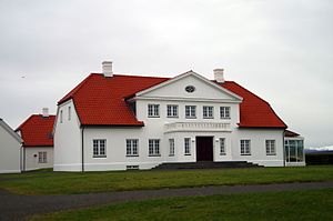
Bessastaðir
Building in Álftanes, Iceland
Distance: Approx. 1216 meters
Latitude and longitude: 64.10583333,-21.99555556
Bessastaðir (Icelandic pronunciation: [ˈpɛsːaˌstaːðɪr̥]) is the official residence of the president of Iceland. It is situated in Álftanes (Garðabær Municipality), about 15 kilometres (9.3 mi) from the capital city, Reykjavík.

Álftanes
Town and former municipality in Southwest Constituency, Iceland
Distance: Approx. 804 meters
Latitude and longitude: 64.10722222,-22.01638889
Álftanes (Icelandic pronunciation: [ˈaul̥taˌnɛːs]) is the name of a town and a collection of small peninsulas in Iceland. It means swan peninsula. The best known of these peninsulas extrudes from the eastern part of Reykjanes with the town of the same name in the Capital Region of Iceland.

Nauthólsvík
Distance: Approx. 4894 meters
Latitude and longitude: 64.1212,-21.9285
Nauthólsvík (Icelandic pronunciation: [ˈnœytˌhoulsˌviːk], "bull hill bay") is a Seaside resort and a small neighbourhood in Reykjavík, the capital city of Iceland, about 900 metres (3,000 ft) from Perlan. It has a beach with an artificial hot spring – hot water is pumped into a man-made lagoon. The temperature of the ocean is usually about 12 to 16 °C (54 to 61 °F) during the summer and drops down to about −2 °C (28 °F) in the winter.
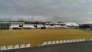
Kaplakriki
Multi-purpose stadium in Hafnarfjörður, Iceland
Distance: Approx. 4655 meters
Latitude and longitude: 64.07583333,-21.93861111
Kaplakriki is a multi-purpose stadium in Hafnarfjörður, Iceland. It is currently used mostly for football matches and is the home stadium of Fimleikafélag Hafnarfjarðar. The stadium holds over 6,000 spectators and has offers 3,050 seats.
Icelandic Road Administration
Distance: Approx. 4778 meters
Latitude and longitude: 64.0799,-21.9299
The Road and Coastal Administration (Icelandic: Vegagerðin [ˈvɛːɣaˌcɛrðɪn] ) is a state run institution in Iceland whose purpose is to construct and maintain roads and infrastructure (land and sea) in rural areas and between urban areas. Formerly belonging to the Ministry of the Interior, it is now part of the Ministry of Infrastructure (until November 2021 named Ministry of Transport and Local Government). Vegagerðin is the legal owner of the roads and has the authority to execute construction of infrastructures on demand from the ministry.
Hafnarfjordur Free Church
Distance: Approx. 4540 meters
Latitude and longitude: 64.069382,-21.955048
Hafnarfjordur Free Church (Icelandic: Fríkirkjan í Hafnarfirði) is a church in the Free Lutheran congregation of Iceland, located in Hafnarfjordur. The church was founded on 22 April 1913. It's Iceland's third largest religious body, after the Reykjavik Free Church and the Church of Iceland.
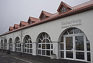
Hafnarborg
Art Museum in Hafnarfjörður, Iceland
Distance: Approx. 4663 meters
Latitude and longitude: 64.0678,-21.9554
Hafnarborg, The Hafnarfjördur Centre of Culture and Fine Art, is a public art museum located in Hafnarfjörður, Iceland. It was opened in May 1988 but the foundation for the institution was laid in 1983 when Dr. Sverrir Magnússon and his wife, Ingibjörg Sigurjónsdóttir donated their house along with a substantial collection of art and books to Hafnarfjörður on the seventy-fifth anniversary of the incorporation of the town.
Stjörnuvöllur
Football stadium in Iceland
Distance: Approx. 4492 meters
Latitude and longitude: 64.0875,-21.92888889
Samsung völlurinn ([ˈvœtlʏrɪn]) also known as Stjörnuvöllur [ˈstjœ(r)tnʏˌvœtlʏr̥] is a football stadium in Garðabær. It is located in Reykjavík, and seats 990 individuals in one stand, but can hold about 410 standing spectators additionally. It is the home stadium for Icelandic top-division football team Stjarnan.
International School of Iceland
Private international school in Garðabær, Iceland
Distance: Approx. 3860 meters
Latitude and longitude: 64.09338056,-21.938775
The International School of Iceland (abbreviated ISI; official name in Icelandic: Alþjóðaskólinn á Íslandi) is a private, non-profit school in Garðabær, Iceland. It is an international school in the Reykjavík area of Iceland, first established in 1960 as the American Embassy School. ISI has received support in the form of grants, training and consultation from the Office of Overseas Schools in Washington, D.C. since the 1960s.

Icelandic Museum of Design and Applied Art
Art museum in Garðabær, Iceland
Distance: Approx. 4829 meters
Latitude and longitude: 64.0891,-21.9206
The Icelandic Museum of Design and Applied Art (Icelandic: Hönnunarsafn Íslands) is a museum of product and furniture design in the town Garðabær, near Reykjavík in Iceland. The collection was started in 1998, but the museum did not open until 2010. It has a permanent exhibition consisting mainly of Scandinavian design objects of the last hundred years.

Skerjafjörður
Distance: Approx. 3443 meters
Latitude and longitude: 64.125,-21.975
Skerjafjörður (Icelandic pronunciation: [ˈscɛrjaˌfjœrðʏr̥], "skerry fjord") is a fjord located immediately west of Iceland's capital Reykjavík. It is part of a larger bay, Faxaflói, on Iceland's west coast.
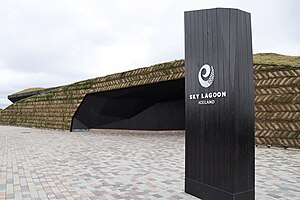
Sky Lagoon
Hot spring spa
Distance: Approx. 3774 meters
Latitude and longitude: 64.1164891,-21.9488657
Sky Lagoon is a geothermal spa in southwestern Iceland.
Weather in this IP's area
overcast clouds
12 Celsius
12 Celsius
11 Celsius
12 Celsius
1000 hPa
100 %
1000 hPa
1000 hPa
10000 meters
6.17 m/s
200 degree
100 %
04:20:43
22:48:11