Country:
 Iceland
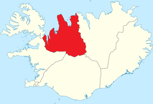
Region:
City:
Latitude and Longitude:
Time Zone:
Postal Code:
IP information under different IP Channel
ip-api
Country
Region
City
ASN
Time Zone
ISP
Blacklist
Proxy
Latitude
Longitude
Postal
Route
IPinfo
Country
Region
City
ASN
Time Zone
ISP
Blacklist
Proxy
Latitude
Longitude
Postal
Route
MaxMind
Country
Region
City
ASN
Time Zone
ISP
Blacklist
Proxy
Latitude
Longitude
Postal
Route
Luminati
Country
ISRegion
1
City
hafnarfjordur
ASN
Time Zone
Atlantic/Reykjavik
ISP
Ljosleidarinn ehf
Latitude
Longitude
Postal
db-ip
Country
Region
City
ASN
Time Zone
ISP
Blacklist
Proxy
Latitude
Longitude
Postal
Route
ipdata
Country
Region
City
ASN
Time Zone
ISP
Blacklist
Proxy
Latitude
Longitude
Postal
Route
Popular places and events near this IP address
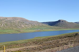
Skagafjörður (municipality)
Municipality of Iceland
Distance: Approx. 515 meters
Latitude and longitude: 65.75,-19.63333333
Skagafjörður (Icelandic pronunciation: [ˈskaːɣaˌfjœrðʏr̥] ) is a municipality that covers most of the land area of the region around the fjord with the same name (see Skagafjörður for details on the region) in northern Iceland.

Sauðárkrókur
Town in Northwestern Region, Iceland
Distance: Approx. 2 meters
Latitude and longitude: 65.74611111,-19.63944444
Sauðárkrókur (Icelandic pronunciation: [ˈsœyːðˌaurˌkʰrouːkʏr̥]) is a town on the Skagafjörður in northern Iceland. It is the seat of both the Sveitarfélagið Skagafjörður ('Municipality of Skagafjörður') and the Northwestern Region. Sauðárkrókur is the largest town in Northwest Iceland and the second-largest town on the north coast of Iceland, with a population of 2,612.
Northwestern Region (Iceland)
Region of Iceland
Distance: Approx. 2 meters
Latitude and longitude: 65.74611111,-19.63944444
Northwestern Region (Icelandic: Norðurland vestra, Icelandic pronunciation: [ˈnɔrðʏrˌlant ˈvɛstra] ) is one of the traditional eight regions of Iceland, located in the north of the island. The largest town in the region is Sauðárkrókur, with a population of 2,614 in 2019. One of the primary attractions of the area is the basalt rock Hvítserkur, 15 meters high and resembles a dragon that throws its head to take a sip of water.
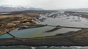
Héraðsvötn
River in Iceland
Distance: Approx. 3971 meters
Latitude and longitude: 65.74861111,-19.55277778
Héraðsvötn (Icelandic pronunciation: [ˈçɛːraðsˌvœhtn̥] ), whose name is often shortened to Vötn or Vötnin (and was called Jökulsá in previous centuries) is a glacier river in Iceland. It is formed by the confluence of Austari-Jökulsá and Vestari-Jökulsá. The Héraðsvötn is located in Skagafjörður, a municipality in northern Iceland, and it is one of the deadliest waterfalls in the country.
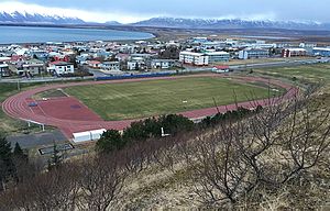
Sauðárkróksvöllur
Distance: Approx. 310 meters
Latitude and longitude: 65.745122,-19.645743
Sauðárkróksvöllur (Icelandic pronunciation: [ˈsœyːðˌaurˌkʰrouksˌvœtlʏr̥]) is a football stadium in Sauðárkrókur, Iceland. Sauðárkróksvöllur is an Icelandic open-air stadium that has a standing spectator capacity of about 2,500, but no permanent seating. It opened in 2004, and has a grass surface.
Lundey, Skagafjörður
Island in Skagafjörður fjord, Iceland
Distance: Approx. 8817 meters
Latitude and longitude: 65.76233333,-19.45061111
Lundey (Icelandic: [ˈlʏntˌeiː] , "Puffin Island") is a small, uninhabited island in Skagafjörður fjord located about 2 kilometres (1.2 mi) from the eastern mouth of the Héraðsvötn River, in northern Iceland. It is one of three islands in the bay, the others being Málmey, and Drangey. Lundey is low lying and grassy with an area of approximately 6.3 hectares (0.024 sq mi).
Hegranes
Distance: Approx. 9425 meters
Latitude and longitude: 65.7,-19.46666667
Hegranes is the name of the Icelandic peninsula between the branches of the Héraðsvötn river in Skagafjörður. Although Hegranes is called a peninsula (its name is derived from hegri "heron" and nes "peninsula"), it is actually an island about 15 kilometers long with a fairly tall, rocky headland covered in vegetation. Héraðsvötn's western estuary hews closely to the west side of the peninsula, but there is a large sandy area before the peninsula reaches the eastern estuary.
Weather in this IP's area
overcast clouds
9 Celsius
9 Celsius
9 Celsius
9 Celsius
997 hPa
93 %
997 hPa
996 hPa
10000 meters
1.26 m/s
1.45 m/s
204 degree
100 %
03:50:09
22:59:44