Country:
 Romania
Region:
City:
Latitude and Longitude:
Time Zone:
Postal Code:
IP information under different IP Channel
ip-api
Country
Region
City
ASN
Time Zone
ISP
Blacklist
Proxy
Latitude
Longitude
Postal
Route
IPinfo
Country
Region
City
ASN
Time Zone
ISP
Blacklist
Proxy
Latitude
Longitude
Postal
Route
MaxMind
Country
Region
City
ASN
Time Zone
ISP
Blacklist
Proxy
Latitude
Longitude
Postal
Route
Luminati
Country
RORegion
b
City
bucharest
ASN
Time Zone
Europe/Bucharest
ISP
Orange Romania S.A.
Latitude
Longitude
Postal
db-ip
Country
Region
City
ASN
Time Zone
ISP
Blacklist
Proxy
Latitude
Longitude
Postal
Route
ipdata
Country
Region
City
ASN
Time Zone
ISP
Blacklist
Proxy
Latitude
Longitude
Postal
Route
Popular places and events near this IP address
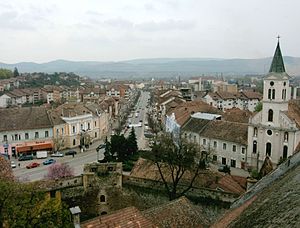
Aiud
City in Alba County, Romania
Distance: Approx. 1664 meters
Latitude and longitude: 46.31222222,23.72916667
Aiud (Romanian pronunciation: [aˈjud] ; Latin: Brucla, Hungarian: Nagyenyed, Hungarian pronunciation: [ˈnɒɟɛɲɛd]; German: Straßburg am Mieresch) is a city located in Alba County, Transylvania, Romania. The city's population is 21,307 (2021). It has the status of municipiu.

Alsó-Fehér County
Distance: Approx. 2253 meters
Latitude and longitude: 46.31666667,23.73333333
Alsó-Fehér was an administrative county (comitatus) of the Kingdom of Hungary. Its territory is now in western Romania (central Transylvania). The latest capital of the county was Nagyenyed (present-day Aiud).
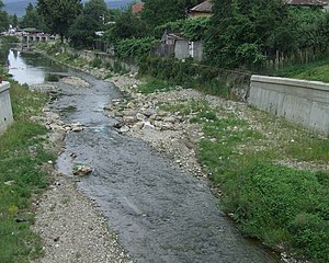
Aiud (river)
River in Alba County, Romania
Distance: Approx. 3130 meters
Latitude and longitude: 46.3187,23.7471
The Aiud or Aiudul de Sus (Hungarian: Enyed-patak) is a left tributary of the river Mureș in Transylvania, Romania. It discharges into the Mureș in Aiud. The upper reach is also known as Siloș.
Ciugud (river)
River in Alba County, Romania
Distance: Approx. 9853 meters
Latitude and longitude: 46.3746,23.7857
The Ciugud (Hungarian: Csüged-patak) is a right tributary of the river Mureș in Transylvania, Romania. It discharges into the Mureș in Inoc. Its length is 15 km (9.3 mi) and its basin size is 35 km2 (14 sq mi).
Gârbova (Mureș)
River in Alba County, Romania
Distance: Approx. 5468 meters
Latitude and longitude: 46.251,23.7117
The Gârbova (Hungarian: Orbói-patak) is a right tributary of the river Mureș in Transylvania, Romania. It discharges into the Mureș in Țifra, south of Aiud. Its length is 17 km (11 mi) and its basin size is 35 km2 (14 sq mi).
Rât (Mureș)
River in Alba County, Romania
Distance: Approx. 3101 meters
Latitude and longitude: 46.301,23.757
The Rât (Hungarian: Háporton-patak) is a left tributary of the river Mureș in Transylvania, Romania. It discharges into the Mureș in Ciumbrud. Its length is 15 km (9.3 mi) and its basin size is 76 km2 (29 sq mi).

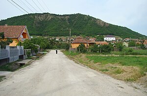
Mirăslău
Commune in Alba, Romania
Distance: Approx. 7421 meters
Latitude and longitude: 46.36666667,23.71666667
Mirăslău (German: Mireslau; Hungarian: Miriszló) is a commune located in Alba County, Transylvania, Romania. It has a population of 1,805 as of 2021. The commune is composed of six villages: Cicău (Csákó), Decea (Marosdécse), Lopadea Veche (Oláhlapád), Mirăslău, Ormeniș (Marosörményes), and Rachiș (Oláhrákos).
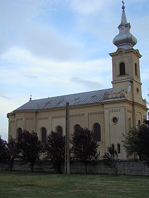
Lopadea Nouă
Commune in Alba, Romania
Distance: Approx. 7910 meters
Latitude and longitude: 46.28333333,23.81666667
Lopadea Nouă (Hungarian: Magyarlapád; German: Schaufeldorf) is a commune located in Alba County, Transylvania, Romania. It is composed of eight villages: Asinip (Asszonynépe), Băgău (Magyarbagó), Beța (Magyarbece), Cicârd (Csengerpuszta), Ciuguzel (Fugad), Lopadea Nouă, Ocnișoara (Kisakna), and Odverem (Vadverem). At the 2002 census, the commune had 3,001 inhabitants, of which 53% were Reformed and 45% Romanian Orthodox.
Rădești, Alba
Commune in Alba, Romania
Distance: Approx. 3711 meters
Latitude and longitude: 46.26666667,23.71666667
Rădești (formerly Tâmpăhaza; German: Thomaskirch; Hungarian: Tompaháza) is a commune located in Alba County, Transylvania, Romania. It is composed of four villages: Leorinț (Laurentzi; Lőrincréve), Meșcreac (Weichseldorf; Meggykerék), Rădești, and Șoimuș (Magyarsolymos).
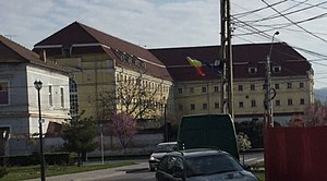
Aiud Prison
Romanian prison complex
Distance: Approx. 1706 meters
Latitude and longitude: 46.31347222,23.72726111
Aiud Prison is a prison complex in Aiud, Alba County, located in central Transylvania, Romania. It is infamous for the treatment of its political inmates, especially during World War II under the rule of Ion Antonescu, and later under the Communist regime.
Weather in this IP's area
clear sky
30 Celsius
30 Celsius
30 Celsius
30 Celsius
1018 hPa
37 %
1018 hPa
991 hPa
10000 meters
0.81 m/s
1.73 m/s
33 degree
06:00:55
21:02:07