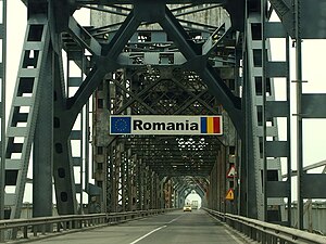
Country:
 Romania
Region:
City:
Latitude and Longitude:
Time Zone:
Postal Code:
IP information under different IP Channel
ip-api
Country
Region
City
ASN
Time Zone
ISP
Blacklist
Proxy
Latitude
Longitude
Postal
Route
IPinfo
Country
Region
City
ASN
Time Zone
ISP
Blacklist
Proxy
Latitude
Longitude
Postal
Route
MaxMind
Country
Region
City
ASN
Time Zone
ISP
Blacklist
Proxy
Latitude
Longitude
Postal
Route
Luminati
Country
RORegion
b
City
sector2
ASN
Time Zone
Europe/Bucharest
ISP
iNES GROUP SRL
Latitude
Longitude
Postal
db-ip
Country
Region
City
ASN
Time Zone
ISP
Blacklist
Proxy
Latitude
Longitude
Postal
Route
ipdata
Country
Region
City
ASN
Time Zone
ISP
Blacklist
Proxy
Latitude
Longitude
Postal
Route
Popular places and events near this IP address
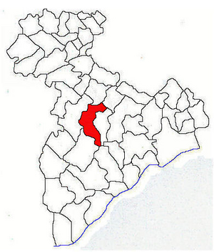
Giurgiu County
County of Romania
Distance: Approx. 5489 meters
Latitude and longitude: 44.16,25.9
Giurgiu (Romanian pronunciation: [ˈdʒjurdʒju] ) is a county (județ) of Romania on the border with Bulgaria, in Muntenia, with the capital city at Giurgiu.
Valea Porumbenilor
River in Giurgiu County, Romania
Distance: Approx. 9964 meters
Latitude and longitude: 44.12638889,25.71361111
The Valea Porumbenilor (also: Trestenic) is a right tributary of the river Câlniștea in Romania. It discharges into the Câlniștea near Naipu. Its length is 24 km (15 mi) and its basin size is 166 km2 (64 sq mi).
Râiosul
River in Giurgiu County, Romania
Distance: Approx. 7111 meters
Latitude and longitude: 44.10583333,25.76222222
The Râiosul or Ileana is a left tributary of the river Câlniștea in Romania. It flows into the Câlniștea in Naipu. Its length is 12 km (7.5 mi) and its basin size is 50 km2 (19 sq mi).
Ismar
River in Romania
Distance: Approx. 4732 meters
Latitude and longitude: 44.14805556,25.77833333
The Ismar is a right tributary of the river Câlniștea in Romania. It discharges into the Câlniștea in Naipu. It flows through the villages Radu Vodă, Dimitrie Cantemir, Izvoarele, Chiriacu and Petru Rareș.
Milcovăț
River in Giurgiu, Romania
Distance: Approx. 7087 meters
Latitude and longitude: 44.18694444,25.77555556
The Milcovăț is a left tributary of the river Glavacioc in Romania. It discharges into the Glavacioc in Ghimpați. Its length is 45 km (28 mi) and its basin size is 215 km2 (83 sq mi).
Glavacioc
River in Giurgiu, Romania
Distance: Approx. 3522 meters
Latitude and longitude: 44.16027778,25.80194444
The Glavacioc is a left tributary of the river Câlniștea in Romania. It discharges into the Câlniștea near Cămineasca. Its length is 120 km (75 mi) and its basin size is 682 km2 (263 sq mi).
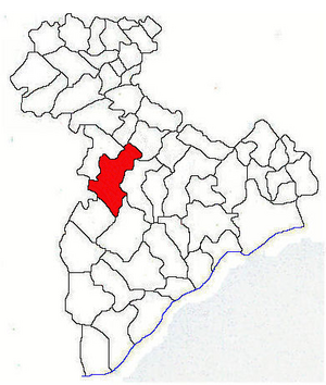
Schitu, Giurgiu
Commune in Giurgiu, Romania
Distance: Approx. 1349 meters
Latitude and longitude: 44.13333333,25.85
Schitu is a commune located in Giurgiu County, Muntenia, Romania. It is composed of four villages: Bila, Cămineasca, Schitu, and Vlașin. The commune is situated in the Wallachian Plain, at an altitude of 81 m (266 ft), on the banks of the river Câlniștea and its left tributary, the Glavacioc.

Stoenești, Giurgiu
Commune in Giurgiu, Romania
Distance: Approx. 4264 meters
Latitude and longitude: 44.1377,25.8899
Stoenești is a commune located in Giurgiu County, Muntenia, Romania. It is composed of three villages: Ianculești, Mirău and Stoenești.
Ghimpați
Commune in Giurgiu, Romania
Distance: Approx. 7848 meters
Latitude and longitude: 44.2,25.78333333
Ghimpați is a commune located in Giurgiu County, Muntenia, Romania. It is composed of four villages: Copaciu, Ghimpați, Naipu, and Valea Plopilor. The commune is situated in the Wallachian Plain, on the banks of the river Câlniștea and its left tributary, the Glavacioc.
Weather in this IP's area
few clouds
26 Celsius
25 Celsius
25 Celsius
26 Celsius
1013 hPa
33 %
1013 hPa
1004 hPa
10000 meters
4.1 m/s
8.14 m/s
59 degree
11 %
06:02:23
20:43:36