Country:
 Germany
Region:
City:
Latitude and Longitude:
Time Zone:
Postal Code:
IP information under different IP Channel
ip-api
Country
Region
City
ASN
Time Zone
ISP
Blacklist
Proxy
Latitude
Longitude
Postal
Route
IPinfo
Country
Region
City
ASN
Time Zone
ISP
Blacklist
Proxy
Latitude
Longitude
Postal
Route
MaxMind
Country
Region
City
ASN
Time Zone
ISP
Blacklist
Proxy
Latitude
Longitude
Postal
Route
Luminati
Country
DEASN
Time Zone
Europe/Berlin
ISP
Pixel X e.K.
Latitude
Longitude
Postal
db-ip
Country
Region
City
ASN
Time Zone
ISP
Blacklist
Proxy
Latitude
Longitude
Postal
Route
ipdata
Country
Region
City
ASN
Time Zone
ISP
Blacklist
Proxy
Latitude
Longitude
Postal
Route
Popular places and events near this IP address

Germanisches Nationalmuseum
Museum in Nuremberg, Germany
Distance: Approx. 529 meters
Latitude and longitude: 49.44833056,11.07556111
The Germanisches Nationalmuseum is a museum in Nuremberg, Germany. Founded in 1852, it houses a large collection of items relating to German culture and art extending from prehistoric times through to the present day. The museum is Germany's largest museum of cultural history.

Weißer Turm station
Distance: Approx. 411 meters
Latitude and longitude: 49.4508039,11.0715905
Weißer Turm station is a Nuremberg U-Bahn station, located on the U1 line. Located in the south-western part of Nuremberg's historical city and at the western end of the pedestrian-only shopping district. It serves as a destination for shoppers and shop employees during the day and provides transportation to the amusement venues (primarily bars and restaurants) located in the vicinity during the evenings.
Opernhaus station
Distance: Approx. 499 meters
Latitude and longitude: 49.4467703,11.0750068
Opernhaus station is a Nuremberg U-Bahn station, located on the U2 and U3.

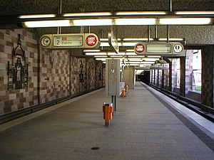
Plärrer station
Distance: Approx. 248 meters
Latitude and longitude: 49.4481,11.0649
Plärrer station is the only Nuremberg U-Bahn station apart from Nürnberg Hauptbahnhof to have an interchange with all the U-Bahn lines – the U1, U2, and U3. Like Aufseßplatz, Hauptbahnhof and Friedrich Ebert Platz orange tiles indicate its intended use as an interchange station between different subway main lines. The station is named after the Plärrer, long an important interchange of various types of transportation including the site of the Nuremberg terminus for the Bavarian Ludwig Railway.

Way of Human Rights
Distance: Approx. 486 meters
Latitude and longitude: 49.44805556,11.075
The Way of Human Rights (German: Straße der Menschenrechte) is a monumental outdoor sculpture in Nuremberg, Germany. It was opened on 24 October 1993. It is sited on the street between the new and old buildings of the Germanisches Nationalmuseum, connecting Kornmarkt street and the medieval city wall.

St. Rochus Cemetery, Nuremberg
Cemetery in Nuremberg, Germany
Distance: Approx. 582 meters
Latitude and longitude: 49.4475,11.06027778
St. Rochus Cemetery (Rochusfriedhof) is a cemetery in Nuremberg, Germany. It is located in the Gostenhof quarter.

Nuremberg Transport Museum
Transport history museum in Nuremberg, Germany
Distance: Approx. 510 meters
Latitude and longitude: 49.445556,11.074444
The Nuremberg Transport Museum (Verkehrsmuseum Nürnberg) in Nuremberg, Germany, consists of Deutsche Bahn's DB Museum and the Museum of Communications (Museum für Kommunikation). It also has two satellite museums at Koblenz-Lützel (DB Museum Koblenz) and Halle (DB Museum Halle). The Nuremberg Transport Museum is one of the oldest technical history museums in Europe and is a milestone on the European Route of Industrial Heritage (ERIH).

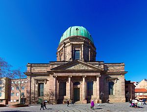
Staatstheater Nürnberg
Theatre and opera house in Nuremberg, Germany
Distance: Approx. 529 meters
Latitude and longitude: 49.44638889,11.07527778
The Staatstheater Nürnberg is a German theatre company in Nuremberg, Bavaria. The theatre is one of four Bavarian state theatres and shows operas, plays, ballets and concerts.
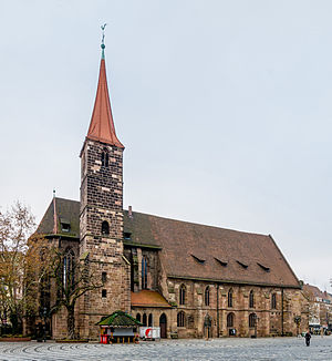
St. Jakob, Nuremberg
Distance: Approx. 284 meters
Latitude and longitude: 49.45,11.07027778
St. Jakob (St James the Greater) is a medieval church of the former free imperial city of Nuremberg in southern Germany. It is dedicated to Saint James the Greater.
St. Elizabeth, Nuremberg
Parish church in Nuremberg in southern Germany
Distance: Approx. 210 meters
Latitude and longitude: 49.44944444,11.06972222
St. Elizabeth's is a Roman Catholic church in Nuremberg in southern Germany. It is dedicated to Elizabeth of Hungary.

Forced Laborer Memorial Transit
Distance: Approx. 208 meters
Latitude and longitude: 49.44831,11.06553
The Forced Laborer Memorial "Transit" is a Nuremberg monument. It is located at the Plärrer, a main traffic junction of the Nuremberg city centre, just outside the city wall. The aim is to keep the memory of the fate of the Nuremberg forced laborers during the Nazi era alive.

Nürnberg-Steinbühl station
Railway station in Germany
Distance: Approx. 557 meters
Latitude and longitude: 49.44280194,11.06813111
Nürnberg-Steinbühl station is a railway station in Nuremberg, Bavaria, Germany. The station is on the Nuremberg–Bamberg and Nuremberg–Roth lines of Deutsche Bahn. It is served by Nuremberg S-Bahn lines S1 and S2.
Weather in this IP's area
clear sky
25 Celsius
24 Celsius
24 Celsius
26 Celsius
1023 hPa
44 %
1023 hPa
988 hPa
10000 meters
3.09 m/s
20 degree
05:43:15
21:00:56