Country:
 Germany
Region:
City:
Latitude and Longitude:
Time Zone:
Postal Code:
IP information under different IP Channel
ip-api
Country
Region
City
ASN
Time Zone
ISP
Blacklist
Proxy
Latitude
Longitude
Postal
Route
IPinfo
Country
Region
City
ASN
Time Zone
ISP
Blacklist
Proxy
Latitude
Longitude
Postal
Route
MaxMind
Country
Region
City
ASN
Time Zone
ISP
Blacklist
Proxy
Latitude
Longitude
Postal
Route
Luminati
Country
DEASN
Time Zone
Europe/Berlin
ISP
euNetworks GmbH
Latitude
Longitude
Postal
db-ip
Country
Region
City
ASN
Time Zone
ISP
Blacklist
Proxy
Latitude
Longitude
Postal
Route
ipdata
Country
Region
City
ASN
Time Zone
ISP
Blacklist
Proxy
Latitude
Longitude
Postal
Route
Popular places and events near this IP address
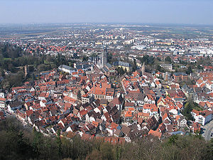
Weinheim
Town in Baden-Württemberg, Germany
Distance: Approx. 4943 meters
Latitude and longitude: 49.55,8.66666667
Weinheim (German: [ˈvaɪnhaɪm] ; Palatine German: Woinem) is a town with about 43,000 inhabitants in northwest Baden-Württemberg, Germany. It is in the Rhine-Neckar Metropolitan Region, approximately 15 km (9 mi) north of Heidelberg and 10 km (6 mi) northeast of Mannheim. Weinheim is known as the "Zwei-Burgen-Stadt", the "town of two castles", after two fortresses overlooking the town from the edge of the Odenwald in the east.

Windeck Castle (Weinheim)
Historic monument in Germany
Distance: Approx. 4686 meters
Latitude and longitude: 49.54611111,8.67722222
Windeck Castle (German: ) stands on a small hill in Weinheim on the Bergstraße. It was built around 1100 to protect the inhabitants of the Lorsch monastery. It was hugely damaged in 1674 by the troops of King Louis XIV of France.

Wachenburg
Distance: Approx. 4015 meters
Latitude and longitude: 49.54944444,8.68555556
The Wachenburg (German: [ˈvaxn̩bʊʁk] ) is a castle on a hill overlooking Weinheim an der Bergstrasse, in Baden-Württemberg, Germany. It was built between 1907 and 1928 by the Weinheimer Senioren-Convent, a Corps of former students. The castle contains a restaurant with a nice view of the country.

Birkenau (Odenwald)
Municipality in Hesse, Germany
Distance: Approx. 1938 meters
Latitude and longitude: 49.5625,8.70694444
Birkenau in the Odenwald is a municipality in the Bergstraße district in southern Hesse, Germany. Its nickname is Das Dorf der Sonnenuhren – “The Sundial Village”.

Hemsbach
Town in Baden-Württemberg, Germany
Distance: Approx. 4824 meters
Latitude and longitude: 49.59027778,8.65638889
Hemsbach (German pronunciation: [ˈhɛmsˌbax] ) is a town with approximately 12,000 inhabitants in the Rhein-Neckar-Kreis of Baden-Württemberg, Germany. It belongs to the European Rhine-Neckar Metropolitan Region (Lower Neckar region until 20 May 2003 and Rhine-Neckar-Odenwald region until 31 December 2005). It is situated on the Bergstraße, 18 km northeast of Mannheim.

Mörlenbach
Municipality in Hesse, Germany
Distance: Approx. 2617 meters
Latitude and longitude: 49.59916667,8.73472222
Mörlenbach is a municipality in the Bergstraße district in southern Hesse, Germany.
Gorxheimertal
Municipality in Hesse, Germany
Distance: Approx. 5017 meters
Latitude and longitude: 49.53333333,8.73333333
Gorxheimertal is a municipality in the Bergstraße district in Hesse, Germany. It is in the Odenwald and the Rhine Neckar Area.
Exotenwald Weinheim
Arboretum in Baden-Württemberg, Germany
Distance: Approx. 4446 meters
Latitude and longitude: 49.5451,8.6845
The Exotenwald Weinheim (about 60 hectares) is a forest arboretum located beside the Schlosspark in Weinheim, Baden-Württemberg, Germany. It is open daily without charge. The arboretum was established in 1871 by Christian Friedrich Gustav Freiherr von Berckheim (1817–1889), former Minister of State and Großhofmeister at the court in Karlsruhe, on the grounds of a baroque estate founded in 1725.

Schau- und Sichtungsgarten Hermannshof
Distance: Approx. 4942 meters
Latitude and longitude: 49.5477,8.6697
The Schau- und Sichtungsgarten Hermannshof (2.2 hectares), also known as the Hermannshof Weinheim, is a privately owned show and trial garden at Babostraße 5, Weinheim, Baden-Württemberg, Germany. It is open to the public daily, admission is free. Today's garden was first established over 200 years ago.
Goldkopf
Distance: Approx. 5241 meters
Latitude and longitude: 49.53361111,8.69444444
Goldkopf (Gold Head) is a mountain of Baden-Württemberg, Germany. It is 324 m above sea level.
Grundelbach
River in Germany
Distance: Approx. 4187 meters
Latitude and longitude: 49.55388889,8.67527778
Grundelbach is a river of Baden-Württemberg and Hesse, Germany. It passes through Gorxheimertal and flows into the Weschnitz in Weinheim.

Weinheim (Bergstraße) Hauptbahnhof
Station in Weinheim, Baden-Württemberg, Germany
Distance: Approx. 4804 meters
Latitude and longitude: 49.55333333,8.66527778
Weinheim (Bergstraße) Hauptbahnhof is a station in the town of Weinheim in the German state of Baden-Württemberg. It is served by Intercity services on the Main-Neckar Railway between Frankfurt and Heidelberg/Mannheim. The Weschnitz Valley Railway (Weschnitztalbahn) to Furth in the Odenwald starts at Weinheim station.
Weather in this IP's area
clear sky
27 Celsius
27 Celsius
26 Celsius
29 Celsius
1021 hPa
45 %
1021 hPa
1003 hPa
10000 meters
3.09 m/s
80 degree
05:52:10
21:10:47