Country:
 Germany
Region:
City:
Latitude and Longitude:
Time Zone:
Postal Code:
IP information under different IP Channel
ip-api
Country
Region
City
ASN
Time Zone
ISP
Blacklist
Proxy
Latitude
Longitude
Postal
Route
IPinfo
Country
Region
City
ASN
Time Zone
ISP
Blacklist
Proxy
Latitude
Longitude
Postal
Route
MaxMind
Country
Region
City
ASN
Time Zone
ISP
Blacklist
Proxy
Latitude
Longitude
Postal
Route
Luminati
Country
DEASN
Time Zone
Europe/Berlin
ISP
euNetworks GmbH
Latitude
Longitude
Postal
db-ip
Country
Region
City
ASN
Time Zone
ISP
Blacklist
Proxy
Latitude
Longitude
Postal
Route
ipdata
Country
Region
City
ASN
Time Zone
ISP
Blacklist
Proxy
Latitude
Longitude
Postal
Route
Popular places and events near this IP address

Buxtehude
Town in Lower Saxony, Germany
Distance: Approx. 1445 meters
Latitude and longitude: 53.47694444,9.70111111
Buxtehude (German pronunciation: [bʊkstəˈhuːdə]), officially the Hanseatic City of Buxtehude (German: Hansestadt Buxtehude, Low German: Hansestadt Buxthu (German pronunciation: [bʊkstˈhu])), is a town on the Este River in Northern Germany, belonging to the district of Stade in Lower Saxony. It is part of the Hamburg Metropolitan Region and attached to the city's S-Bahn rapid transit network. Buxtehude is a medium-sized town and the second largest municipality in the Stade district (Landkreis).
Apensen
Municipality in Lower Saxony, Germany
Distance: Approx. 5872 meters
Latitude and longitude: 53.43583333,9.61555556
Apensen is a municipality southwest of Hamburg (Germany). Apensen has a population of about 3,000, the area of 20.74 km2 and belongs to the district Stade, Lower Saxony. It belonged to the Prince-Archbishopric of Bremen.
Halepaghen Grammar School
Gymnasium school
Distance: Approx. 1112 meters
Latitude and longitude: 53.47638889,9.69305556
The Halepaghen Grammar School (German: Gymnasium Halepaghen-Schule), or HPS, is a gymnasium ("grammar school") in Buxtehude (Lower Saxony, Germany). The school was mentioned for the first time in 1390 as an (original) grammar school. The school was named after Gerhard Halepaghe (born about 1430 in Buxtehude; died April 1484 in Buxtehude), a famous graduate from Buxtehude.

Apensen (Samtgemeinde)
Samtgemeinde in Lower Saxony, Germany
Distance: Approx. 5984 meters
Latitude and longitude: 53.43333333,9.61666667
Apensen is a Samtgemeinde ("collective municipality") in the district of Stade, in Lower Saxony, Germany. Its seat is in the village Apensen.
Apensen station
Distance: Approx. 5703 meters
Latitude and longitude: 53.44166667,9.61222222
Apensen is a railway station, located in the municipality Apensen, Lower Saxony, in northwestern Germany. It is owned and operated by EVB, with regular trains on the line between Bremerhaven and Buxtehude. As of 2009, the station was included in the fare zone of the Hamburger Verkehrsverbund.
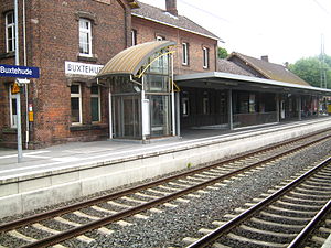
Buxtehude station
Distance: Approx. 354 meters
Latitude and longitude: 53.47027778,9.68722222
Buxtehude is a railway station in northwestern Germany. The station is located in the town of Buxtehude. It is located on two railway lines: the Lower Elbe Railway, which runs between Cuxhaven and Hamburg, and the Bremerhaven–Buxtehude line of the Eisenbahnen und Verkehrsbetriebe Elbe-Weser (EVB) to Bremervörde (and therefore, to Bremerhaven and Zeven).

Nottensdorf
Municipality in Lower Saxony, Germany
Distance: Approx. 6034 meters
Latitude and longitude: 53.48333333,9.6
Nottensdorf is a municipality in the district of Stade, Lower Saxony, Germany.

Neukloster station
Distance: Approx. 3524 meters
Latitude and longitude: 53.48138889,9.63944444
Neukloster (German: Bahnhof or Haltestelle Neukloster) is a rapid transit train station, located in Neukloster, a village now part of the town Buxtehude, Lower Saxony. The trains of the Hamburg S-Bahn serve the station with the line S5 from Elbgaustraße station via central station to Stade.

3rd Panzer Division (Bundeswehr)
Military unit
Distance: Approx. 567 meters
Latitude and longitude: 53.462012,9.686412
The 3rd Armoured Division (German: 3. Panzerdivision) was formed on 2 July 1956 in Hamburg and was one of the first major formations of the new German Army or Bundeswehr after the Second World War. The 3rd Armoured Division was stationed on the North German Plain between the rivers Elbe and Weser.

Daensen folding chair
Distance: Approx. 4794 meters
Latitude and longitude: 53.424047,9.688783
The Daensen folding chair consists of the metallic remains of a folding chair which were discovered in 1899 in sand from a Bronze Age tumulus near Daensen, a part of Buxtehude, Lower Saxony, Germany. The chair is the southernmost and most richly decorated example of the eighteen known folding chairs of the Nordic Bronze Age in Northern Europe. The fittings, along with a reconstruction, are in the permanent exhibition of the Archaeological Museum Hamburg in Harburg, Hamburg.

Ovelgönne bread roll
Distance: Approx. 4105 meters
Latitude and longitude: 53.447161,9.739006
The Ovelgönne bread roll is the remaining part of a bread roll originating from the Pre-Roman Iron Age of Northern Europe, which was found in 1952 during archaeological excavations in a loam mine in the Buxtehude district Ovelgönne in Lower Saxony, Germany. The piece of bread is the oldest surviving formed bakery product from Europe. The find, along with a reconstruction, are in the permanent exhibition of the Archaeological Museum Hamburg in Harburg, Hamburg.

Estering
Distance: Approx. 2055 meters
Latitude and longitude: 53.44888889,9.69194444
Estering is a rallycross race track situated in Buxtehude, Lower Saxony Germany. It primarily ran the German round of the FIA European Rallycross Championship until 2019. It also ran the World RX of Germany event of the FIA World Rallycross Championship from 2014 to 2018 before being dropped in 2019.
Weather in this IP's area
clear sky
23 Celsius
22 Celsius
23 Celsius
23 Celsius
1023 hPa
53 %
1023 hPa
1022 hPa
10000 meters
2.06 m/s
260 degree
05:32:32
21:22:42