Country:
 Austria
Region:
City:
Latitude and Longitude:
Time Zone:
Postal Code:
IP information under different IP Channel
ip-api
Country
Region
City
ASN
Time Zone
ISP
Blacklist
Proxy
Latitude
Longitude
Postal
Route
IPinfo
Country
Region
City
ASN
Time Zone
ISP
Blacklist
Proxy
Latitude
Longitude
Postal
Route
MaxMind
Country
Region
City
ASN
Time Zone
ISP
Blacklist
Proxy
Latitude
Longitude
Postal
Route
Luminati
Country
ATASN
Time Zone
Europe/Vienna
ISP
euNetworks GmbH
Latitude
Longitude
Postal
db-ip
Country
Region
City
ASN
Time Zone
ISP
Blacklist
Proxy
Latitude
Longitude
Postal
Route
ipdata
Country
Region
City
ASN
Time Zone
ISP
Blacklist
Proxy
Latitude
Longitude
Postal
Route
Popular places and events near this IP address

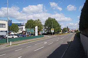
Zeltweg
Municipality in Styria, Austria
Distance: Approx. 7686 meters
Latitude and longitude: 47.19055556,14.75111111
Zeltweg (German: [ˈt͡sɛltˌveːk]) is a town in Styria, Austria. It is located in the Aichfeld basin of the Mur River in Upper Styria. Larger municipalities in the vicinity are Judenburg, Knittelfeld and Fohnsdorf.
Spielberg, Styria
Municipality in Styria, Austria
Distance: Approx. 8329 meters
Latitude and longitude: 47.21666667,14.78333333
Spielberg (formerly: Spielberg bei Knittelfeld) is a city located in the Bezirk Murtal in Styria, Austria.

Großlobming
Place in Styria, Austria
Distance: Approx. 3130 meters
Latitude and longitude: 47.16666667,14.8
Großlobming is a municipality in the district of Murtal in Styria, Austria. It is located on the banks of the river Mur.
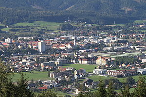
Knittelfeld
Municipality in Styria, Austria
Distance: Approx. 7242 meters
Latitude and longitude: 47.215,14.82944444
Knittelfeld (German: [ˈknitl̩ˌfɛlt]) is a city in Styria, Austria, located on the banks of the Mur river. The name of the town has become notorious for the Knittelfeld Putsch of September 7, 2002, a party meeting of the Freedom Party of Austria, which resulted in the 2002 Austrian elections.

Kleinlobming
Former municipality in Styria, Austria
Distance: Approx. 1054 meters
Latitude and longitude: 47.15,14.84722222
Kleinlobming is a village and former municipality in the Bezirk Murtal in Styria, Austria. Since the 2015 Styria municipal structural reform, it is part of the municipality Großlobming.
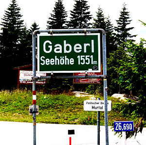
Gaberl Pass
Mountain pass in the Austrian Alps
Distance: Approx. 7768 meters
Latitude and longitude: 47.10805556,14.91527778
Gaberl Pass (el. 1,551 m [5,089 ft]) is a high mountain pass in the Austrian Alps in the Bundesland of Styria. A steep road connects Köflach with the upper Mur River valley, running next to the Stubalpe.

Eppenstein
Former municipality in Styria, Austria
Distance: Approx. 7420 meters
Latitude and longitude: 47.13083333,14.73944444
Eppenstein is a former municipality in the district of Murtal in the Austrian state of Styria. Since the 2015 Styria municipal structural reform, it is part of the municipality Weißkirchen in Steiermark. Eppenstein lies in the Lavanttal Alps stretching along the narrow valley of the Granitzenbach creek, which runs from the Upper Mur valley in the north up to the Obdach Saddle pass and the Lavant Valley valley in Carinthia.

Reisstraße
Former municipality in Styria, Austria
Distance: Approx. 1722 meters
Latitude and longitude: 47.13472222,14.82972222
Reisstraße is a former municipality in the district of Murtal in Styria, Austria. Since the 2015 Styria municipal structural reform, it is part of the municipality Weißkirchen in Steiermark.
Weißkirchen in Steiermark
Municipality in Styria, Austria
Distance: Approx. 7181 meters
Latitude and longitude: 47.15388889,14.73861111
Weißkirchen in Steiermark is a municipality in the district of Murtal in Styria, Austria.
Apfelberg
Former municipality in Styria, Austria
Distance: Approx. 5876 meters
Latitude and longitude: 47.20277778,14.83472222
Apfelberg (meaning "Apple Mountain" in German) is a former municipality in the district of Murtal in the Austrian state of Styria. Since the 2015 Styria municipal structural reform, it is part of the municipality Knittelfeld.
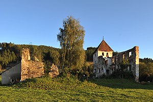
Burgruine Eppenstein
Distance: Approx. 7592 meters
Latitude and longitude: 47.131,14.737
Burgruine Eppenstein is a ruined medieval castle overlooking Eppenstein in the Austrian state of Styria. It was built about 1000 AD as the ancestral seat of the Eppenstein dynasty, whose members served as Margraves of Styria and were enfeoffed with the Duchy of Carinthia in the 11th and 12th century.
Lobmingtal
Municipality in Styria, Austria
Distance: Approx. 3130 meters
Latitude and longitude: 47.16666667,14.8
Lobmingtal is a municipality with 1,825 residents (as of 1 January 2016) in the Murtal District and Judenburg judicial district of Styria, Austria. The municipality has an area of 54.38 km2 (21.00 sq mi). As part of the Styria municipal structural reform, in 2015, the towns of Großlobming and Kleinlobming were merged, and initially called "Großlobming".
Weather in this IP's area
few clouds
22 Celsius
21 Celsius
21 Celsius
22 Celsius
1023 hPa
53 %
1023 hPa
928 hPa
10000 meters
1.54 m/s
20 %
05:36:06
20:37:57