Country:
 Austria
Region:
City:
Latitude and Longitude:
Time Zone:
Postal Code:
IP information under different IP Channel
ip-api
Country
Region
City
ASN
Time Zone
ISP
Blacklist
Proxy
Latitude
Longitude
Postal
Route
IPinfo
Country
Region
City
ASN
Time Zone
ISP
Blacklist
Proxy
Latitude
Longitude
Postal
Route
MaxMind
Country
Region
City
ASN
Time Zone
ISP
Blacklist
Proxy
Latitude
Longitude
Postal
Route
Luminati
Country
ATRegion
9
ASN
Time Zone
Europe/Vienna
ISP
Arelion Sweden AB
Latitude
Longitude
Postal
db-ip
Country
Region
City
ASN
Time Zone
ISP
Blacklist
Proxy
Latitude
Longitude
Postal
Route
ipdata
Country
Region
City
ASN
Time Zone
ISP
Blacklist
Proxy
Latitude
Longitude
Postal
Route
Popular places and events near this IP address
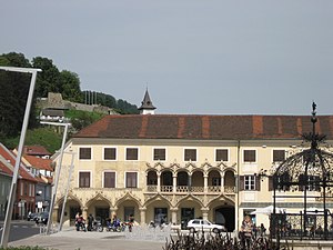
Bruck an der Mur
Municipality in Styria, Austria
Distance: Approx. 1253 meters
Latitude and longitude: 47.41666667,15.26666667
Bruck an der Mur (German: [bʁʊk an dɐ ˈmuːɐ]) is a city of some 15,970 people located in the district Bruck-Mürzzuschlag, in the Austrian state of Styria. It is located at the confluence of the rivers Mur and Mürz. Its manufacturing includes metal products and paper.

Kapfenberg
Municipality in Styria, Austria
Distance: Approx. 1852 meters
Latitude and longitude: 47.43333333,15.28333333
Kapfenberg ([ˈkapfənbɛʁk]), with 22,182 inhabitants in 2023, is the third largest city in Styria, Austria, and lies in the valley of the Mürz near the town of Bruck an der Mur. The town's landmark is Burg Oberkapfenberg. Every year in June, the Ritterfest ("knights' festival") takes place at the castle, which is one of the largest events of its kind in Austria.

Mürz
River in Styria, Austria
Distance: Approx. 972 meters
Latitude and longitude: 47.4099,15.2752
The Mürz (German pronunciation: [mʏʁt͡s] ) is a river in Styria, Austria, with a length of 84 km (52 mi). Its drainage basin is 1,505 km2 (581 sq mi). The Mürz begins at the confluence of the Stille Mürz and Kalte Mürz near Kaltenbach, Neuberg and the border to Lower Austria.

Franz Fekete Stadium
Austrian football stadium
Distance: Approx. 3294 meters
Latitude and longitude: 47.44388889,15.30055556
Franz Fekete Stadion is a multipurpose stadium in Kapfenberg, Austria. It is used mostly for football matches and is the home ground of Kapfenberger SV. The stadium was constructed in 1950, and currently holds 9,640 people. It was named in 2001 after long time Mayor Franz Fekete (1921-2009).
Sportzentrum Kapfenberg
Indoor sporting arena
Distance: Approx. 3265 meters
Latitude and longitude: 47.44436,15.297717
Sportzentrum Kapfenberg is an indoor sporting arena located in Kapfenberg, Austria. The capacity of the arena is 4,600 people. It is used mostly for ice hockey.

Oberaich
Former municipality in Styria, Austria
Distance: Approx. 5353 meters
Latitude and longitude: 47.4,15.21666667
Oberaich is a former municipality in the district of Bruck-Mürzzuschlag in Styria, Austria. Since the 2015 Styria municipal structural reform, it is part of the municipality Bruck an der Mur.

Frauenberg, Styria
Former municipality in Styria, Austria
Distance: Approx. 5354 meters
Latitude and longitude: 47.43333333,15.35
Frauenberg is a former municipality in the district of Bruck-Mürzzuschlag in Styria, Austria. Since the 2015 Styria municipal structural reform, it is part of the municipality Sankt Marein im Mürztal.

Oberkapfenberg Castle
Distance: Approx. 2709 meters
Latitude and longitude: 47.440025,15.29356944
Oberkapfenberg Castle (German: Burg Oberkapfenberg) is a castle in Styria, Austria. It is 592 metres (1,942 ft) above sea level.

Kapfenberg Airport
Airport in Austria
Distance: Approx. 5825 meters
Latitude and longitude: 47.45761111,15.33152778
Kapfenberg Airport (German: Flugplatz Kapfenberg, ICAO: LOGK) is a public use airport located 3 kilometres (2 mi) east of Kapfenberg, Steiermark, Austria.
Bruck-Mürzzuschlag District
District in Styria, Austria
Distance: Approx. 1250 meters
Latitude and longitude: 47.4167,15.2667
Bruck-Mürzzuschlag (German: [bʁʊk myɐ̯t͡sˈt͡suːʃlak]) is a district in Styria, Austria. It came into effect on January 1, 2013, when the merging of the districts Bruck an der Mur and Mürzzuschlag occurred. Just 2 years later, on 1 January 2015, the district was restructured in the Styria municipal structural reform and reduced from 37 to 19 towns.

Rennfeld
Distance: Approx. 6550 meters
Latitude and longitude: 47.4,15.36666667
Rennfeld (1,629 m) is a mountain in the Fischbach Alps, part of the Prealps east of the Mur. It is the westernmost peak of the range. Rennfeld is the highest of the three hausbergs of the city of Bruck an der Mur and towers over a kilometre above the Mur Valley to the west.

Heiligen-Geist-Kapelle, Bruck
Chapel in Bruck an der Mur, Styria, Austria
Distance: Approx. 1269 meters
Latitude and longitude: 47.4053,15.2835
The Heiligen-Geist-Kapelle in Bruck an der Mur, Styria, Austria, is a chapel named for the Holy Spirit. It was built in late-Gothic style, originally dedicated to the Trinity, which explains its unusual triangular floorplan, with three similar walls, all with a portal. The building fell into disrepair in the 18th century and was used for several purposes such as a postmaster's stable, an inn and for housing, which changed the interior.
Weather in this IP's area
scattered clouds
20 Celsius
20 Celsius
19 Celsius
20 Celsius
1025 hPa
89 %
1025 hPa
959 hPa
10000 meters
2.33 m/s
2.18 m/s
346 degree
37 %
05:32:11
20:38:18