Country:
 Croatia
Region:
City:
Latitude and Longitude:
Time Zone:
Postal Code:
IP information under different IP Channel
ip-api
Country
Region
City
ASN
Time Zone
ISP
Blacklist
Proxy
Latitude
Longitude
Postal
Route
IPinfo
Country
Region
City
ASN
Time Zone
ISP
Blacklist
Proxy
Latitude
Longitude
Postal
Route
MaxMind
Country
Region
City
ASN
Time Zone
ISP
Blacklist
Proxy
Latitude
Longitude
Postal
Route
Luminati
Country
HRRegion
21
City
zagreb
ASN
Time Zone
Europe/Zagreb
ISP
Arelion Sweden AB
Latitude
Longitude
Postal
db-ip
Country
Region
City
ASN
Time Zone
ISP
Blacklist
Proxy
Latitude
Longitude
Postal
Route
ipdata
Country
Region
City
ASN
Time Zone
ISP
Blacklist
Proxy
Latitude
Longitude
Postal
Route
Popular places and events near this IP address

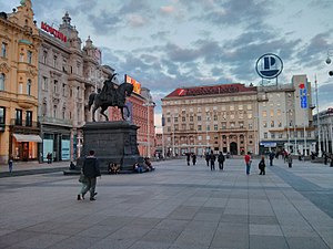
Zagreb
Capital and largest city of Croatia
Distance: Approx. 155 meters
Latitude and longitude: 45.81305556,15.9775
Zagreb ( ZAH-greb Croatian: [zǎːɡreb] ) is the capital and largest city of Croatia. It is in the north of the country, along the Sava river, at the southern slopes of the Medvednica mountain. Zagreb stands near the international border between Croatia and Slovenia at an elevation of approximately 158 m (518 ft) above sea level.
Kaptol, Zagreb
Distance: Approx. 78 meters
Latitude and longitude: 45.81472222,15.97888889
Kaptol is a part of Zagreb, Croatia in the Upper Town and it is the seat of the Roman Catholic archbishop of Zagreb. Due to its historical associations, in Croatian "Kaptol" is also used as a metonym for the leadership of the Roman Catholic Church in Croatia.

Zagreb Cathedral
Cathedral in Croatia
Distance: Approx. 134 meters
Latitude and longitude: 45.81444444,15.97972222
Zagreb Cathedral (Cathedral of the Assumption of the Blessed Virgin Mary and Saints Stephen and Ladislav), is a Roman Catholic cathedral located at Kaptol, Zagreb. It is the second tallest building in Croatia and also the most monumental sacral building of Gothic architecture southeast of the Alps. It is one of the most important and biggest symbols of the city of Zagreb and Croatia, and in 2013 it entered in the Register of Cultural Goods of Croatia.
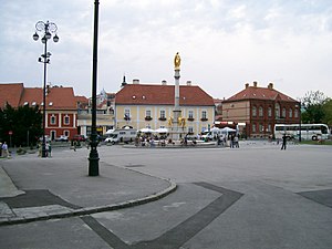
Ban Jelačić Square
Square in Zagreb, Croatia
Distance: Approx. 161 meters
Latitude and longitude: 45.81305556,15.97722222
Ban Jelačić Square (pronounced [bâːn jɛ̌lat͡ʃit͡ɕ]; Croatian: Trg bana Jelačića) is the central square of the city of Zagreb, Croatia, named after Ban Josip Jelačić. The official name is Trg bana Josipa Jelačića. The square is colloquially called Jelačić plac.

Croatian Franciscan Province of Saints Cyril and Methodius
Distance: Approx. 189 meters
Latitude and longitude: 45.8161,15.9779
The Croatian Franciscan Province of Saints Cyril and Methodius (Croatian: Hrvatska franjevačka provincija sv. Ćirila i Metoda) is a province of the Franciscan Order of the Catholic Church based in Zagreb which is active in Croatia and Serbia (including Vojvodina province and the City of Belgrade). The province was formed in 1900, and has monasteries throughout northern Croatia, as well as in Subotica, Bač, Novi Sad and Zemun, Serbia.

Dolac Market
Distance: Approx. 47 meters
Latitude and longitude: 45.81416667,15.9775
Dolac (pronounced [dɔ̌lat͡s]) is a farmers' market located in Gornji Grad - Medveščak city district of Zagreb, Croatia. Dolac is the most visited and the best known farmer's market in Zagreb, well known for its combination of traditional open market with stalls and a sheltered market below. It is located only a few dozen meters away from the main city square, Ban Jelačić Square, between the oldest parts of Zagreb, Gradec and Kaptol.

Medveščak (stream)
River in Croatia
Distance: Approx. 172 meters
Latitude and longitude: 45.81472222,15.97583333
Medveščak (pronounced [medʋeʃtʃǎːk], also called Crikvenik) is a creek in central Zagreb, Croatia. It flows from Kraljičin zdenac in Podsljeme down along the southern slopes of the Medvednica mountain to the Manduševac Fountain, its mouth. The creek was covered in 1898 and today forms part of the Zagreb sewer system.

Krvavi Most
Street in Zagreb, Croatia
Distance: Approx. 166 meters
Latitude and longitude: 45.8147,15.9759
Krvavi most (lit. "Bloody Bridge") is a street in the heart of Zagreb, capital of Croatia. It is named after the former bridge over the Medveščak creek, which was rendered useless after the covering of the creek.
Kaptol manors in Zagreb
Distance: Approx. 68 meters
Latitude and longitude: 45.81482778,15.97862778
The Kaptol manors form a series of 25 manors (Croatian: kurije, from Latin: curia) along the Kaptol Street in Zagreb, Croatia that were used to house canons and other officials of the Archdiocese of Zagreb. The manors were built at various times between the Middle Ages and the 19th century. Most of those preserved date from the Baroque period (late 17th and 18th century), while those in the best condition are mostly from the 19th century.

Komedija Theatre
Croatian theater
Distance: Approx. 185 meters
Latitude and longitude: 45.8160595,15.9780737
Komedija Theatre (Croatian: Zagrebačko gradsko kazalište "Komedija") is a theatre in Zagreb, Croatia which specializes in musicals. It was opened in 1950 as a legal successor to the Zagreb Drama Theatre and the Vedri Kerempuh Theatre. Notable pieces that premiered there include the 1971 musical Jalta, Jalta and the first Croatian rock opera Gubec-beg (1981).

1918 protest in Zagreb
Event in the Kingdom of Serbs, Croats and Slovenes
Distance: Approx. 161 meters
Latitude and longitude: 45.81305556,15.97722222
On 5 December 1918, the National Guards (an armed force of the National Council of the State of Slovenes, Croats and Serbs) and Sokol volunteers suppressed a protest and engaged in an armed clash against the soldiers of the 25th Regiment of the Royal Croatian Home Guard and the 53rd Regiment of the former Austro-Hungarian Common Army on 5 December 1918, four days after the proclamation of the Kingdom of Serbs, Croats and Slovenes. National Guardsmen stopped the soldiers at the Ban Jelačić Square in Zagreb. Reasons for the protest and the conflict are not very well documented, but the soldiers who marched down Ilica Street from the Rudolf barracks towards the central city square shouted slogans against the King Peter I of Serbia and in support of republicanism and the Croatian People's Peasant Party leader Stjepan Radić.
Zagreb metropolitan area
Urban area in Croatia
Distance: Approx. 157 meters
Latitude and longitude: 45.8131,15.9772
The Zagreb metropolitan area is the metropolitan area of Zagreb. The metropolitan area covers three counties in the Croatia, with an area of 4,930 km2. The largest cities or towns within the metropolitan area are Zagreb, Velika Gorica, Samobor and Zaprešić.
Weather in this IP's area
clear sky
21 Celsius
22 Celsius
20 Celsius
22 Celsius
1023 hPa
87 %
1023 hPa
1008 hPa
10000 meters
1.54 m/s
270 degree
05:35:45
20:29:08