Country:
 Czech Republic
Region:
City:
Latitude and Longitude:
Time Zone:
Postal Code:
IP information under different IP Channel
ip-api
Country
Region
City
ASN
Time Zone
ISP
Blacklist
Proxy
Latitude
Longitude
Postal
Route
IPinfo
Country
Region
City
ASN
Time Zone
ISP
Blacklist
Proxy
Latitude
Longitude
Postal
Route
MaxMind
Country
Region
City
ASN
Time Zone
ISP
Blacklist
Proxy
Latitude
Longitude
Postal
Route
Luminati
Country
CZRegion
10
ASN
Time Zone
Europe/Prague
ISP
Arelion Sweden AB
Latitude
Longitude
Postal
db-ip
Country
Region
City
ASN
Time Zone
ISP
Blacklist
Proxy
Latitude
Longitude
Postal
Route
ipdata
Country
Region
City
ASN
Time Zone
ISP
Blacklist
Proxy
Latitude
Longitude
Postal
Route
Popular places and events near this IP address
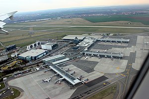
Václav Havel Airport Prague
Airport serving Prague, Czech Republic
Distance: Approx. 3979 meters
Latitude and longitude: 50.1018,14.2632
Václav Havel Airport Prague (Czech: Letiště Václava Havla Praha) Czech pronunciation: [ˈlɛcɪʃcɛ ˈvaːt͡slava ˈɦavla ˈpraɦa] (IATA: PRG, ICAO: LKPR), formerly Prague Ruzyně International Airport (Mezinárodní letiště Praha-Ruzyně, Czech pronunciation: [ˈmɛzɪnaːrodɲiː ˈlɛcɪʃcɛ ˈpraɦa ˈruzɪɲɛ]), is an international airport of Prague, the capital of the Czech Republic. The airport was founded in 1937, when it replaced the Kbely Airport (founded in 1918). It was reconstructed and extended in 1956, 1968, 1997, and 2006.

Přední Kopanina
Suburb in Prague, Czech Republic
Distance: Approx. 2442 meters
Latitude and longitude: 50.11666667,14.3
Přední Kopanina is a suburb of Prague, Czech Republic. It is located 10 km (6.2 mi) northwest of the city centre in the vicinity of Václav Havel Airport Prague and has a population of 667 (2006). First mentioned in 1285, it was incorporated as a municipal district of Prague in 1974.

Okoř
Municipality in Central Bohemian, Czech Republic
Distance: Approx. 3400 meters
Latitude and longitude: 50.16194444,14.25861111
Okoř is a municipality and village in Prague-West District in the Central Bohemian Region of the Czech Republic. It has about 100 inhabitants.

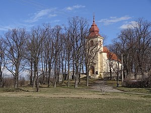
Tuchoměřice
Municipality in Central Bohemian, Czech Republic
Distance: Approx. 17 meters
Latitude and longitude: 50.13555556,14.28222222
Tuchoměřice is a municipality and village in Prague-West District in the Central Bohemian Region of the Czech Republic. It has about 1,700 inhabitants.

Číčovice
Municipality in Central Bohemian, Czech Republic
Distance: Approx. 3326 meters
Latitude and longitude: 50.15666667,14.24944444
Číčovice is a municipality and village in Prague-West District in the Central Bohemian Region of the Czech Republic. It has about 300 inhabitants.

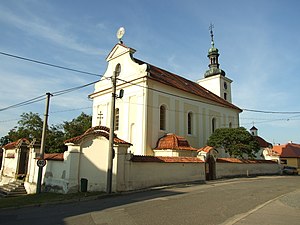
Kněževes (Prague-West District)
Municipality in Central Bohemian, Czech Republic
Distance: Approx. 2285 meters
Latitude and longitude: 50.12027778,14.26055556
Kněževes is a municipality and village in Prague-West District in the Central Bohemian Region of the Czech Republic. It has about 700 inhabitants.
Lichoceves
Municipality in Central Bohemian, Czech Republic
Distance: Approx. 1941 meters
Latitude and longitude: 50.15277778,14.28444444
Lichoceves (Czech pronunciation: [ˈlɪxotsɛvɛs]) is a municipality and village in Prague-West District in the Central Bohemian Region of the Czech Republic. It has about 400 inhabitants.
Statenice
Municipality in the Czech Republic
Distance: Approx. 2725 meters
Latitude and longitude: 50.14277778,14.31861111
Statenice is a municipality and village in Prague-West District in the Central Bohemian Region of the Czech Republic. It has about 1,600 inhabitants.
Středokluky
Municipality in Central Bohemian, Czech Republic
Distance: Approx. 3446 meters
Latitude and longitude: 50.13222222,14.23416667
Středokluky is a municipality and village in Prague-West District in the Central Bohemian Region of the Czech Republic. It has about 1,300 inhabitants.

Velké Přílepy
Municipality in Central Bohemian, Czech Republic
Distance: Approx. 3624 meters
Latitude and longitude: 50.16055556,14.31444444
Velké Přílepy is a municipality and village in Prague-West District in the Central Bohemian Region of the Czech Republic. It has about 3,600 inhabitants.

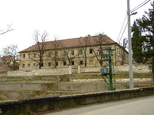
Okoř Castle
Castle in the Czech Republic
Distance: Approx. 3727 meters
Latitude and longitude: 50.16413889,14.25538889
Okoř is a castle on a low rocky promontory in Okoř, north-west of Prague, about 15 kilometres (9 mi) from the city centre, in the Central Bohemian Region of the Czech Republic. In 1228 a stronghold was built in the small hamlet of Okoř. It was later modified into a Gothic castle, founded in 1359 by Frantisek Rokyčansky, a wealthy burgher of Prague's Old Town.
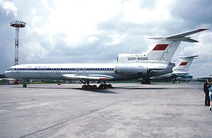
Aeroflot Flight 141
1973 aviation accident
Distance: Approx. 1976 meters
Latitude and longitude: 50.11777778,14.27888889
Aeroflot Flight 141 was an international flight from Moscow to Prague. On 19 February 1973, the Tupolev Tu-154 crashed 1.5 kilometres (0.93 mi; 0.81 nmi) short of runway 25 (now runway 24) of Prague Ruzyně Airport (now Václav Havel Airport Prague). Most of the passengers survived the crash, but many died in the fire that followed.
Weather in this IP's area
clear sky
15 Celsius
15 Celsius
14 Celsius
17 Celsius
1025 hPa
75 %
1025 hPa
991 hPa
10000 meters
3.09 m/s
220 degree
05:27:50
20:50:38