Country:
 USA
USARegion:
City:
Latitude and Longitude:
Time Zone:
Postal Code:
IP information under different IP Channel
ip-api
Country
Region
City
ASN
Time Zone
ISP
Blacklist
Proxy
Latitude
Longitude
Postal
Route
IPinfo
Country
Region
City
ASN
Time Zone
ISP
Blacklist
Proxy
Latitude
Longitude
Postal
Route
MaxMind
Country
Region
City
ASN
Time Zone
ISP
Blacklist
Proxy
Latitude
Longitude
Postal
Route
Luminati
Country
USASN
Time Zone
America/Chicago
ISP
INTERNAP-2BLK
Latitude
Longitude
Postal
db-ip
Country
Region
City
ASN
Time Zone
ISP
Blacklist
Proxy
Latitude
Longitude
Postal
Route
ipdata
Country
Region
City
ASN
Time Zone
ISP
Blacklist
Proxy
Latitude
Longitude
Postal
Route
Popular places and events near this IP address
The Real World: Boston
Season of television series
Distance: Approx. 146 meters
Latitude and longitude: 42.35777778,-71.07083333
The Real World: Boston is the sixth season of MTV's reality television series The Real World, which focuses on a group of diverse strangers living together for several months in a different city each season, as cameras follow their lives and interpersonal relationships. It is the only season of The Real World to be filmed in the New England region of the United States, specifically in Massachusetts. The season featured seven people who lived in a converted historic firehouse at 127 Mt.

Charles Street Meeting House
Distance: Approx. 131 meters
Latitude and longitude: 42.3579,-71.0706
The Charles Street Meeting House is an early-nineteenth-century historic church in Beacon Hill at 70 Charles Street, Boston, Massachusetts. The church has been used over its history by several Christian denominations, including Baptists, the First African Methodist Episcopal Church, and Unitarian Universalist. In the 1980s, it was renovated and adapted for use as office space, with the exterior restored and preserved.
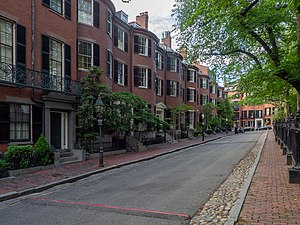
Louisburg Square
Distance: Approx. 110 meters
Latitude and longitude: 42.35843056,-71.06863333
Louisburg Square is a street in the Beacon Hill neighborhood of Boston, Massachusetts, bisected by a small private park. The park, which is bounded by Pinckney Street to the north and Mount Vernon Street to the south, is maintained by the Louisburg Square Proprietors. While the Proprietors pay taxes to the City of Boston, the city does not own the park or its garden.
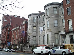
David Sears House
Historic house in Massachusetts, United States
Distance: Approx. 211 meters
Latitude and longitude: 42.35685,-71.06668611
The David Sears House is a historic house located along Beacon Street in the Beacon Hill neighborhood of Boston, Massachusetts. The three-story house was built in several stages between 1816 and 1875. Now a National Historic Landmark, it was one of the first houses built of granite in the city, and was designed by Alexander Parris for David Sears, a prominent merchant, philanthropist, and landowner.
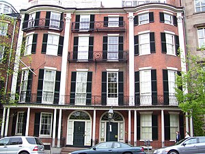
Headquarters House (Boston)
Historic house in Massachusetts, United States
Distance: Approx. 126 meters
Latitude and longitude: 42.35655556,-71.06825
William Hickling Prescott House, also known as the Headquarters House, is an historic house museum located at 55 Beacon Street on Beacon Hill in Boston, Massachusetts. It is the left-hand portion of a double townhouse at 54–55 Beacon Street, seen in the photograph. The townhouse, built in 1808 to a design by Asher Benjamin, was designated a National Historic Landmark in 1964 for its association with William Hickling Prescott (1796–1859), one of the nation's first historians.
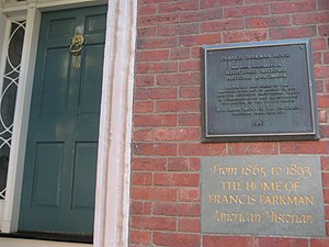
Francis Parkman House
Historic house in Massachusetts, United States
Distance: Approx. 62 meters
Latitude and longitude: 42.35694444,-71.06916667
The Francis Parkman House is a National Historic Landmark at 50 Chestnut Street, on Beacon Hill in Boston, Massachusetts. Speculated to be designed by Cornelius Coolidge and built in 1824, it is one of a series of fine brick townhouses on Beacon Hill. Its significance lies in its ownership and occupancy by noted historian and horticulturalist Francis Parkman (1823–1893) from 1865 until his death.

Samuel Gridley and Julia Ward Howe House
Historic house in Massachusetts, United States
Distance: Approx. 191 meters
Latitude and longitude: 42.35775,-71.06680556
The Samuel Gridley and Julia Ward Howe House is a historic rowhouse at 13 Chestnut Street in the Beacon Hill neighborhood of Boston, Massachusetts, United States. It was designated a National Historic Landmark in 1974 for its association with the social reform couple, Julia Ward Howe and Samuel Gridley Howe. The Howes lived in the house, which was likely designed by renowned Boston architect Charles Bulfinch, from 1863 to 1866.
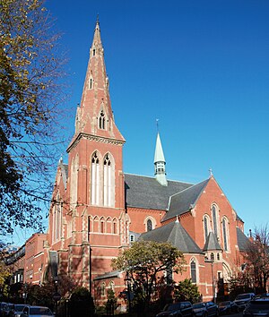
Church of the Advent (Boston)
Church in Massachusetts, United States
Distance: Approx. 199 meters
Latitude and longitude: 42.357757,-71.071496
The Church of the Advent is an Episcopal parish in Boston, Massachusetts, United States. The church is housed in a Victorian Gothic building, faced in brick with eight large change ringing bells and a 172-foot spire. It has long been a prominent center of Anglo-Catholic worship.
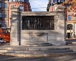
The Founders Memorial
Sculpture in Boston, Massachusetts, U.S.
Distance: Approx. 167 meters
Latitude and longitude: 42.356502,-71.067581
The Founders Memorial, also known as Founding of Boston, is a 1930 sculpture by John Francis Paramino in Boston Common, in Boston, Massachusetts.

Oneida Football Club Monument
Monument in Boston, Massachusetts, U.S.
Distance: Approx. 211 meters
Latitude and longitude: 42.35625,-71.06716667
The Oneida Football Club Monument, sometimes called Football Tablet, is a monument by Joseph Coletti and installed on the Boston Common, in Boston, Massachusetts, United States. It remembers the Oneida Football Club, the first organized team to play any kind of football in the United States. The game played by the club, known as the "Boston game", was an informal local variant that predated the codification of rules for association football, rugby football, or American football.
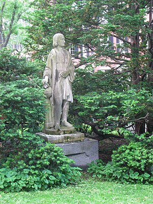
Statue of Christopher Columbus (Beacon Hill, Boston)
Statue in Beacon Hill, Boston, Massachusetts, U.S.
Distance: Approx. 141 meters
Latitude and longitude: 42.358751,-71.068823
A statue of Christopher Columbus is installed in Boston's Beacon Hill neighborhood, within Louisburg Square, in the U.S. state of Massachusetts. A Greek merchant, Joseph Iasigi, presented the statue to the city in December 1849. A captain of one of his vessels had loaded it onto a ship in Italy as ballast, alongside a statue of Aristides which was also donated.

Statue of Aristides (Boston)
Statue in Boston, Massachusetts, U.S.
Distance: Approx. 81 meters
Latitude and longitude: 42.358163,-71.068702
A statue of Aristides is installed in Boston's Beacon Hill neighborhood, within Louisburg Square, in the U.S. state of Massachusetts. The 6-foot (1.8 m) sculpture was imported from Italy in 1834 by Joseph Iasigi, then Turkish consul, who lived at 3 Louisburg Sq. When the other proprietors of the Square were reluctant to accept the statue, he sweetened his offer with a statue of Christopher Columbus for the north end of its park.
Weather in this IP's area
overcast clouds
27 Celsius
27 Celsius
25 Celsius
29 Celsius
1019 hPa
49 %
1019 hPa
1017 hPa
10000 meters
3.13 m/s
6.26 m/s
114 degree
100 %
05:33:09
20:08:09