Country:
 USA
USARegion:
City:
Latitude and Longitude:
Time Zone:
Postal Code:
IP information under different IP Channel
ip-api
Country
Region
City
ASN
Time Zone
ISP
Blacklist
Proxy
Latitude
Longitude
Postal
Route
IPinfo
Country
Region
City
ASN
Time Zone
ISP
Blacklist
Proxy
Latitude
Longitude
Postal
Route
MaxMind
Country
Region
City
ASN
Time Zone
ISP
Blacklist
Proxy
Latitude
Longitude
Postal
Route
Luminati
Country
USASN
Time Zone
America/Chicago
ISP
INTERNAP-2BLK
Latitude
Longitude
Postal
db-ip
Country
Region
City
ASN
Time Zone
ISP
Blacklist
Proxy
Latitude
Longitude
Postal
Route
ipdata
Country
Region
City
ASN
Time Zone
ISP
Blacklist
Proxy
Latitude
Longitude
Postal
Route
Popular places and events near this IP address

Dublin/Pleasanton station
Rapid transit station in Pleasanton, California, US
Distance: Approx. 1863 meters
Latitude and longitude: 37.701663,-121.899232
Dublin/Pleasanton station is a Bay Area Rapid Transit (BART) station on the border of Dublin and Pleasanton in California. It is the eastern terminus of the Blue Line. It is also a major bus terminal served by six providers.
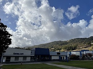
Foothill High School (Pleasanton, California)
Public high school in Pleasanton, California, United States
Distance: Approx. 2543 meters
Latitude and longitude: 37.67305556,-121.91916667
Foothill High School (FHS) is a public high school in Pleasanton, California, United States. It was established in 1973 and is part of the Pleasanton Unified School District. It is a fully accredited WASC school, with its six-year WASC accreditation approved in the 2018–2019 school year.

Arroyo Mocho
River in California, United States
Distance: Approx. 1795 meters
Latitude and longitude: 37.67694444,-121.91222222
Arroyo Mocho is a 34.7-mile-long (55.8 km) stream which originates in the far northeastern corner of Santa Clara County and flows northwesterly into eastern Alameda County, California. After traversing the cities of Livermore and Pleasanton it joins South San Ramon Creek to become Arroyo de la Laguna, which in turn flows to Alameda Creek and thence to San Francisco Bay.
South San Ramon Creek
River in California, United States
Distance: Approx. 1795 meters
Latitude and longitude: 37.67694444,-121.91222222
South San Ramon Creek is a 9.3-mile-long (15.0 km) southward-flowing stream in Alameda County and southern Contra Costa County, in the East Bay region of northern California. The creek is a tributary to Arroyo de la Laguna, flowing in the western Livermore Valley through Dublin and Pleasanton.
Bernal Subbasin
Aquifer
Distance: Approx. 2121 meters
Latitude and longitude: 37.66643056,-121.89811667
The Bernal Subbasin is an aquifer located in the southwestern corner of Livermore Valley Groundwater Basin, Alameda County, California, United States. All of the groundwater in Livermore Valley moves toward the Bernal Subbasin, which is bounded on the east by Pleasanton Fault, on the north by the Park Fault, and on the west by the Calaveras Fault.(Earth Metrics, 1989) All the streams draining the Livermore Valley merge above the Bernal formation and exit this subbasin and Livermore Amador Valley via the Arroyo de la Laguna. Groundwater occurs throughout the valley floor portion of the Bernal Subbasin under conditions ranging from unconfined to confined.

Amador Valley High School
Public high school in Pleasanton, California
Distance: Approx. 2605 meters
Latitude and longitude: 37.66833333,-121.87444444
Amador Valley High School is a comprehensive public high school in Pleasanton, California. It is one of three high schools in the Pleasanton Unified School District, along with Foothill High School and Village High School. Founded as Amador Valley Joint Union High School (AVJUHS), it graduated its first class in 1923.

Hacienda Business Park
Job and housing center in Pleasanton, California
Distance: Approx. 695 meters
Latitude and longitude: 37.69,-121.9
Hacienda Business Park is a 900-acre (364 hectare) mixed-use job center and housing development in Pleasanton, California.

Alameda County Fairgrounds
Fairground in Pleasanton, California, U.S.
Distance: Approx. 2704 meters
Latitude and longitude: 37.66138,-121.88944
The Alameda County Fairgrounds is a 270-acre (110 ha) facility located in Pleasanton, California. It is home to the annual Alameda County Fair, held since 1912, as well as numerous trade shows and community events. Located on its grounds, the Pleasanton Fairgrounds Racetrack was built in 1858, making it the oldest one-mile (1.6 km) horse racing track in the United States.
Amador Valley
Valley in California, United States of America
Distance: Approx. 1859 meters
Latitude and longitude: 37.68305556,-121.87388889
Amador Valley is a valley in eastern Alameda County, California and is the location of the cities of Dublin and Pleasanton. Part of Tri-Valley, the valley is bounded by the foothills of the Diablo Range on the north and south, Pleasanton Ridge to the west, and Livermore Valley to the east. Watercourses draining into the Amador Valley include South San Ramon Creek, Tassajara Creek, Arroyo Mocho, Arroyo Valle, and Arroyo Las Positas, as well as runoff from Pleasanton Ridge.
Rancho Santa Rita
Mexican land grant in California
Distance: Approx. 2770 meters
Latitude and longitude: 37.67,-121.87
Rancho Santa Rita was a 8,894-acre (35.99 km2) Mexican land grant in the Amador Valley and western Livermore Valley, which is in present day Alameda County, California. It was given in 1839 by Governor Juan Alvarado to Jose Dolores Pacheco. The rancho included present day Pleasanton, Asco, and Dougherty.

Arroyo Valle
River in California, United States
Distance: Approx. 2784 meters
Latitude and longitude: 37.66194444,-121.90611111
Arroyo Valle or Arroyo Del Valle is a 36.4-mile-long (58.6 km) westward-flowing stream that begins in northeastern Santa Clara County, California, and flows northwesterly into Alameda County where it is dammed to form Lake Del Valle. After that Arroyo Valle is a tributary to Arroyo de la Laguna which in turn flows into Alameda Creek and thence to San Francisco Bay. In the past, the Arroyo Valle had a significant steelhead migration; however, degradation of the stream in the latter half of the 20th century has decimated this anadromous fish population.

Tulare Lake (Alameda County)
Former lake in northern California
Distance: Approx. 2124 meters
Latitude and longitude: 37.66666667,-121.9
Tulare Lake was a large, shallow lake in eastern Amador Valley, surrounded by Willow Marsh (also known as the Lagoon). Tule rushes and willow trees once lined the marshes and sloughs of its shores. Drainage alterations starting in the 19th century have since reduced the marsh to the Arroyo de la Laguna, and the city of Pleasanton has since expanded across what was once marshland.
Weather in this IP's area
clear sky
26 Celsius
25 Celsius
21 Celsius
28 Celsius
1012 hPa
47 %
1012 hPa
1001 hPa
10000 meters
2.57 m/s
06:08:21
20:19:33