Country:
 USA
USARegion:
City:
Latitude and Longitude:
Time Zone:
Postal Code:
IP information under different IP Channel
ip-api
Country
Region
City
ASN
Time Zone
ISP
Blacklist
Proxy
Latitude
Longitude
Postal
Route
IPinfo
Country
Region
City
ASN
Time Zone
ISP
Blacklist
Proxy
Latitude
Longitude
Postal
Route
MaxMind
Country
Region
City
ASN
Time Zone
ISP
Blacklist
Proxy
Latitude
Longitude
Postal
Route
Luminati
Country
USRegion
al
City
montgomery
ASN
Time Zone
America/Chicago
ISP
WOW-INTERNET
Latitude
Longitude
Postal
db-ip
Country
Region
City
ASN
Time Zone
ISP
Blacklist
Proxy
Latitude
Longitude
Postal
Route
ipdata
Country
Region
City
ASN
Time Zone
ISP
Blacklist
Proxy
Latitude
Longitude
Postal
Route
Popular places and events near this IP address

Terminal Tower
Skyscraper in Cleveland, Ohio, US
Distance: Approx. 193 meters
Latitude and longitude: 41.49833333,-81.69388889
Terminal Tower is a 52-story, 215.8 m (708 ft), landmark skyscraper located on Public Square in the downtown core of Cleveland, Ohio, United States. Built during the skyscraper boom of the 1920s and 1930s, it was the second-tallest building in the world when it was completed. Terminal Tower stood as the tallest building in North America outside of New York City from its completion in 1927 until 1964.

Public Square, Cleveland
Historic central plaza in Cleveland, Ohio, U.S.
Distance: Approx. 177 meters
Latitude and longitude: 41.49972222,-81.69388889
Public Square is the central plaza of Downtown Cleveland, Ohio. Based on an 18th-century New England model, it was part of the original 1796 town plat overseen by city founder General Moses Cleaveland of the Connecticut Land Company. The historical center of the city's downtown, it was added to the National Register of Historic Places in 1975.
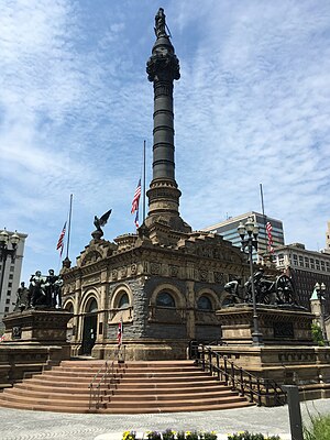
Soldiers' and Sailors' Monument (Cleveland)
Monument in Cleveland, Ohio
Distance: Approx. 183 meters
Latitude and longitude: 41.4994954,-81.6937421
The Cuyahoga County Soldiers' and Sailors' Monument is a major Civil War monument in Cleveland, Ohio, honoring the more than 9,000 individuals from Cuyahoga County who served the Union throughout the war. It was dedicated on July 4, 1894, and is located on the southeast quadrant of Public Square in Downtown Cleveland. It was designed by architect and Civil War veteran Levi Scofield, who also created the monument's sculptures.
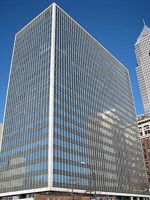
55 Public Square
22-story skyscraper in Cleveland Ohio
Distance: Approx. 119 meters
Latitude and longitude: 41.500263,-81.696039
55 Public Square (formerly known as the Illuminating Building, after the Illuminating Company, the building's primary tenant) is a 22-story skyscraper located at number 55 Public Square, the town square of downtown Cleveland, Ohio. Designed by Carson & Lundin, it is 300 feet (91 m) tall, was completed in 1958, and was the first new skyscraper built in Cleveland since the Terminal Tower complex was completed in 1930. It was also the first tall International Style building in the city and the first to use a reinforced concrete frame.
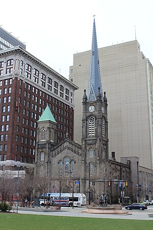
Old Stone Church (Cleveland, Ohio)
Historic church in Ohio, United States
Distance: Approx. 155 meters
Latitude and longitude: 41.50027778,-81.69472222
The Old Stone Church is a historic Presbyterian church located in downtown Cleveland, Ohio, and is the oldest building on Public Square. It is also the second church built within the city limits.

Standard Building (Cleveland, Ohio)
High-rise office tower located in downtown Cleveland, Ohio
Distance: Approx. 186 meters
Latitude and longitude: 41.50082778,-81.69540833
The Standard Building, (originally the Brotherhood of Locomotive Engineers Cooperative National Bank Building and later the Standard Bank Building), is a high-rise apartment building located at the southwest corner of Ontario Street and St. Clair Avenue in downtown Cleveland, Ohio. Rising to a height of 282 feet (86 meters), the Standard Building was the second tallest building in Cleveland when it was completed in 1925.

Society for Savings Building
Building in Cleveland, Ohio
Distance: Approx. 194 meters
Latitude and longitude: 41.50055556,-81.69444444
The Society for Savings Building, also known as the Society Corp. Building, is a high-rise building on Public Square in Downtown Cleveland, Ohio, United States. The building was constructed in 1889, and stood as the tallest building in Cleveland until 1896, when it was surpassed by the 221-foot (67 m) Guardian Bank Building.

75 Public Square
Offices in Cleveland, United States
Distance: Approx. 131 meters
Latitude and longitude: 41.50021389,-81.69509722
75 Public Square is a high-rise office building on Public Square in downtown Cleveland, Ohio. It was designed by the Cleveland architectural firm of Hubbell & Benes and was completed in 1915. It served as the headquarters for the Cleveland Electric Illuminating Company until the construction of the adjacent 55 Public Square in 1958.
Balloonfest '86
Fundraising event in Cleveland, Ohio, U.S.
Distance: Approx. 177 meters
Latitude and longitude: 41.49972222,-81.69388889
Balloonfest '86 was an event in Cleveland, Ohio, United States, held on September 27, 1986, in which the local chapter of United Way set a world record by releasing almost 1.5 million balloons. The event was intended to be a harmless fundraising publicity stunt. However, the released balloons drifted back over the city and Lake Erie and landed in the surrounding area, causing problems for traffic and a nearby airport.
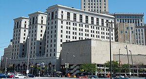
Hotel Cleveland
Distance: Approx. 100 meters
Latitude and longitude: 41.49861111,-81.695
The Hotel Cleveland is a historic hotel on Public Square in Cleveland, Ohio, opened in 1918. It is today part of the Tower City Center mixed-use complex.

Rockefeller Building (Cleveland)
Office in Cleveland, Ohio United States
Distance: Approx. 184 meters
Latitude and longitude: 41.49805556,-81.6975
The Rockefeller Building is a historic high-rise office building in downtown Cleveland, Ohio that was built in 1903-1905 and sits at the corner of West 6th and Superior Avenue across from the Tower City Center complex. The building stands at a height of 212 ft. (64.62 m), rising 17 stories above the street and is named after the Standard Oil of Ohio founder John D. Rockefeller.
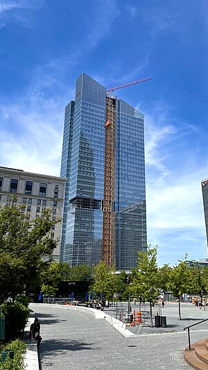
Sherwin-Williams Headquarters
4th tallest building in Cleveland, Ohio
Distance: Approx. 18 meters
Latitude and longitude: 41.49916667,-81.69611111
The Sherwin-Williams Headquarters is a 36-story office tower under construction in Downtown Cleveland, Ohio. At 616 ft (188 m), it is the 4th tallest building in Cleveland, and the 6th tallest building in Ohio. When completed, it will be the global headquarters of Sherwin-Williams, the largest paint and coating company in the world.
Weather in this IP's area
clear sky
20 Celsius
20 Celsius
18 Celsius
22 Celsius
1019 hPa
77 %
1019 hPa
996 hPa
10000 meters
1.51 m/s
1.68 m/s
88 degree
06:17:02
20:49:18