Country:
 USA
USARegion:
City:
Latitude and Longitude:
Time Zone:
Postal Code:
IP information under different IP Channel
ip-api
Country
Region
City
ASN
Time Zone
ISP
Blacklist
Proxy
Latitude
Longitude
Postal
Route
IPinfo
Country
Region
City
ASN
Time Zone
ISP
Blacklist
Proxy
Latitude
Longitude
Postal
Route
MaxMind
Country
Region
City
ASN
Time Zone
ISP
Blacklist
Proxy
Latitude
Longitude
Postal
Route
Luminati
Country
USASN
Time Zone
America/Chicago
ISP
Ses Astra S.A.
Latitude
Longitude
Postal
db-ip
Country
Region
City
ASN
Time Zone
ISP
Blacklist
Proxy
Latitude
Longitude
Postal
Route
ipdata
Country
Region
City
ASN
Time Zone
ISP
Blacklist
Proxy
Latitude
Longitude
Postal
Route
Popular places and events near this IP address

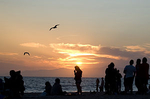
El Segundo, California
City in California, United States
Distance: Approx. 999 meters
Latitude and longitude: 33.92138889,-118.40611111
El Segundo ( EL sə-GUN-doh, Spanish: [el seˈɣundo]; Spanish for 'The Second') is a city in Los Angeles County, California, United States. Located on Santa Monica Bay, it was incorporated on January 18, 1917, and is part of the South Bay Cities Council of Governments. The population was 16,731 as of the 2020 census, a 0.5% increase from 16,654 in the 2010 census.

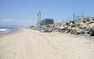
Hyperion sewage treatment plant
Sewage treatment facility in Los Angeles, California
Distance: Approx. 1373 meters
Latitude and longitude: 33.925,-118.42972222
The Hyperion Water Reclamation Plant is a sewage treatment plant in southwest Los Angeles, California, next to Dockweiler State Beach on Santa Monica Bay. The plant is the largest sewage treatment facility in the Los Angeles Metropolitan Area and one of the largest plants in the world. Hyperion is operated by the City of Los Angeles, Department of Public Works, and the Bureau of Sanitation.
Dockweiler State Beach
State beach in Los Angeles County, California, United States
Distance: Approx. 1657 meters
Latitude and longitude: 33.92222222,-118.43416667
Dockweiler State Beach is a beach in Los Angeles, California, with 3.75 miles (6.04 km) of shoreline, a hang gliding practice and training area. Although a unit of the California state park system, it is managed by the Los Angeles County Department of Beaches and Harbors. Part of the park is located directly under the flight path of the adjacent Los Angeles International Airport (LAX).
El Porto, Manhattan Beach, California
Distance: Approx. 1787 meters
Latitude and longitude: 33.903274,-118.419039
El Porto is a beach community that is part of northernmost Manhattan Beach, a city in the South Bay area of Greater Los Angeles in Southern California. The boundary of El Porto is 45th Street on the north side, which is the border with El Segundo, and its Chevron oil refinery, to 38th Street, which was the old border with Manhattan; the east-west boundary is Crest Drive, next to the fence of El Segundo's oil refinery, to El Porto State Beach and the Pacific Ocean. The commercial section of El Porto is along Highland Avenue, which is its only main thoroughfare.
El Porto Beach
Beach in Santa Monica Bay, California, United States
Distance: Approx. 1821 meters
Latitude and longitude: 33.90337222,-118.42156667
El Porto Beach is a California public beach managed by the County of Los Angeles, located in Santa Monica Bay beside El Porto, which is now part of the City of Manhattan Beach, between the beaches of El Segundo Beach and Manhattan Beach, and is protected under the state park system. The entrance to El Porto's large parking lot, which has meters, is at the west end of 45th Street from Highland Avenue. El Porto is one of the most popular beaches in the South Bay area with surfers from near and far because of an underwater canyon that creates waves usually larger than those at neighboring beaches.
Chevron Reef
Distance: Approx. 1548 meters
Latitude and longitude: 33.915123,-118.432624
Chevron Reef, also known as Pratte's Reef, was an artificial reef constructed in 2000 in Santa Monica Bay, offshore from Dockweiler State Beach. It was the first artificial surfing reef in the United States and was the second to be built worldwide. It was removed in 2008.
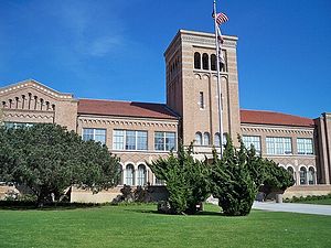
El Segundo High School
Public high school in the United States
Distance: Approx. 689 meters
Latitude and longitude: 33.925,-118.414
El Segundo High School, or ESHS, is a four-year public high school located in El Segundo, California. It is the only secondary school incorporated by El Segundo Unified School District. First built in 1927, the school campus contains 5 main buildings built from a brick facade.

Hyperion, California
Former settlement in California, United States
Distance: Approx. 1681 meters
Latitude and longitude: 33.92611111,-118.43277778
Hyperion is a location in Los Angeles County, California. Hyperion was a stop on the Pacific Electric Redondo Beach via Playa del Rey Line that lay at an elevation of 33 feet (10 m). Hyperion still appeared on USGS maps as of 1934.
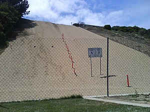
Sand Dune Park
Recreation area in Manhattan Beach, California
Distance: Approx. 2289 meters
Latitude and longitude: 33.89886,-118.41293
Sand Dune Park is an area of public sand dunes partly on a steep slope that is used for exercise in Manhattan Beach, California. The area has been used by amateur and professional athletes and has been featured in fitness magazines and newspaper accounts as a great workout spot. The park around the dune was built on a converted dump site by local residents in 1964.
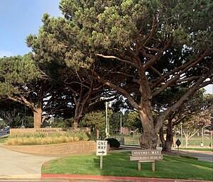
Recreation Park (El Segundo)
Park in El Segundo, California, United States
Distance: Approx. 442 meters
Latitude and longitude: 33.9211,-118.4124
Recreation Park. is a public, urban park in El Segundo, California, a suburb of Los Angeles. Located adjacent to Downtown El Segundo, Recreation Park is bordered by Pine Street on the North, Eucalyptus Drive on the West, and houses on the South and East.

Automobile Driving Museum
Automotive museum in El Segundo, California
Distance: Approx. 2342 meters
Latitude and longitude: 33.924643,-118.392109
The Automobile Driving Museum is an automotive museum located at 610 Lairport Street, El Segundo, California, USA. The museum is nonprofit 501(c)(3) organization, founded in 2002 (2002) by car collectors Stanley Zimmerman and architect Earl Rubenstein. Its mission is to "collect, preserve, exhibit and ride in historic vehicles." It contains about 130 classic, antique, and vintage automobiles created between 1886 and 2000, of which roughly half are on display at any time. Visitors are permitted to touch and sit in most cars, and on Sunday Car Rides, experience driving around in classic vehicles.
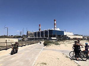
Scattergood Generating Station
Power station in Los Angeles
Distance: Approx. 1035 meters
Latitude and longitude: 33.91861111,-118.42777778
Scattergood Generating Station is an electricity-generating facility in the Playa Del Rey area of Los Angeles, California, in proximity to El Segundo and LAX. Scattergood has an 830 MW capacity spread across three steam turbine units. Owned and operated by the Los Angeles Department of Water and Power (LADWP), the station is a coastal landmark of the Santa Monica Bay in southern California. Plans are in place to convert the station to hydrogen power.
Weather in this IP's area
clear sky
18 Celsius
18 Celsius
17 Celsius
22 Celsius
1011 hPa
90 %
1011 hPa
1007 hPa
10000 meters
0.89 m/s
2.68 m/s
190 degree
06:02:01
19:58:05