Country:
 Germany
Region:
City:
Latitude and Longitude:
Time Zone:
Postal Code:
IP information under different IP Channel
ip-api
Country
Region
City
ASN
Time Zone
ISP
Blacklist
Proxy
Latitude
Longitude
Postal
Route
IPinfo
Country
Region
City
ASN
Time Zone
ISP
Blacklist
Proxy
Latitude
Longitude
Postal
Route
MaxMind
Country
Region
City
ASN
Time Zone
ISP
Blacklist
Proxy
Latitude
Longitude
Postal
Route
Luminati
Country
DEASN
Time Zone
Europe/Berlin
ISP
euNetworks GmbH
Latitude
Longitude
Postal
db-ip
Country
Region
City
ASN
Time Zone
ISP
Blacklist
Proxy
Latitude
Longitude
Postal
Route
ipdata
Country
Region
City
ASN
Time Zone
ISP
Blacklist
Proxy
Latitude
Longitude
Postal
Route
Popular places and events near this IP address
Aachen (district)
District in North Rhine-Westphalia, Germany
Distance: Approx. 2956 meters
Latitude and longitude: 50.75,6.25
The district of Aachen (German: Städteregion Aachen) is a district in the west of North Rhine-Westphalia, Germany. Neighboring districts are Heinsberg, Düren, Euskirchen, and also the Netherlands province of Limburg and the Belgian province of Liège. Its administrative body is the Städteregionsparlament ("regional parliament"), headed by the Städteregionspräsident or "region president" (Tim Grüttemeier (CDU) since 2019).

Stolberg (Rhineland)
Town in North Rhine-Westphalia, Germany
Distance: Approx. 1115 meters
Latitude and longitude: 50.76666667,6.23333333
Stolberg (German pronunciation: [ˈʃtɔlbɛʁk], Ripuarian: Stolbersch) is a town in North Rhine-Westphalia, Germany. It has a long history as an industrial town and belongs to the district Aachen and the lower district court of Eschweiler.

Breinigerberg
Village of Stolberg in North Rhine-Westphalia, Germany
Distance: Approx. 3889 meters
Latitude and longitude: 50.73333333,6.23333333
Breinigerberg is one of 17 districts and villages belonging to the town of Stolberg (Rhineland), which is one of the major towns in the borough of Aachen. According to a census dated 31 December 2005, the village had 971 inhabitants.
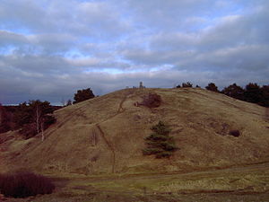
Schlangenberg Nature Reserve
Distance: Approx. 3762 meters
Latitude and longitude: 50.73722222,6.24333333
The nature reserve of Schlangenberg which means snake-mountain is located in the west of Germany close to the Dutch and Belgian border. The reserve is near the village Breinigerberg, 15 kilometres from Aachen or 7 kilometres distant from the city of Stolberg (Rhineland). Schlangenberg itself is a small hill peaking 276 m above sea level.

Adler-Apotheke
Distance: Approx. 1096 meters
Latitude and longitude: 50.76638889,6.23305556
The Adler-Apotheke was a former brass producing factory in the German city of Stolberg. The building was founded in 1575 by Leonard Schleicher. In the 18th century it became the first pharmacy in the district of Aachen.

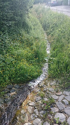
Flachsbach
River in North Rhine-Westphalia, Germany
Distance: Approx. 1941 meters
Latitude and longitude: 50.7537,6.1993
Flachsbach is a rivulet in the German village of Büsbach. It is a right tributary to the river Inde. The Flachsbach flowing through the south of Büsbach has its source in the pasture between the villages Büsbach and Breinig.

Büsbach
Village of Stolberg in North Rhine-Westphalia, Germany
Distance: Approx. 1871 meters
Latitude and longitude: 50.75,6.21666667
Büsbach is the largest of 17 districts and villages belonging to the German town of Stolberg (Rhineland).
Stolberg (Rheinland) Hauptbahnhof
Distance: Approx. 3118 meters
Latitude and longitude: 50.7948,6.2187
Stolberg (Rheinland) Hauptbahnhof is a railway station on the line between Cologne and Aachen. It is the largest station for passengers and freight in the town of Stolberg (Rhineland) in the urban region of Aachen in the German state of North Rhine-Westphalia. It houses the Vennbahn Museum and is situated at a junction.

Mäurer & Wirtz
German personal care product manufacturer
Distance: Approx. 1191 meters
Latitude and longitude: 50.761729,6.232391
Mäurer & Wirtz is a German manufacturer of personal care products and perfumes. Since 1990 the company has been a subsidiary of Dalli Group. The company is managed by the fifth generation of the Wirtz family, joint CEO Hermann Wirtz.
Mausbach
River in Stolberg, Germany
Distance: Approx. 3654 meters
Latitude and longitude: 50.7489,6.261
Mausbach is a small river of North Rhine-Westphalia, Germany. It flows into the Vichtbach near Stolberg.

Saubach (Inde)
River in Germany
Distance: Approx. 3106 meters
Latitude and longitude: 50.7941,6.2266
Saubach is a river of North Rhine-Westphalia, Germany. It is a left tributary of the Inde near Stolberg.

Vichtbach
River in Germany
Distance: Approx. 2656 meters
Latitude and longitude: 50.7905,6.2218
Vichtbach is a river of North Rhine-Westphalia, Germany. It flows into the Inde near Stolberg.
Weather in this IP's area
broken clouds
16 Celsius
15 Celsius
14 Celsius
17 Celsius
1018 hPa
80 %
1018 hPa
990 hPa
10000 meters
1.74 m/s
1.67 m/s
168 degree
56 %
05:59:09
21:23:46