Country:
 Great Britain
Region:
City:
Latitude and Longitude:
Time Zone:
Postal Code:
IP information under different IP Channel
ip-api
Country
Region
City
ASN
Time Zone
ISP
Blacklist
Proxy
Latitude
Longitude
Postal
Route
IPinfo
Country
Region
City
ASN
Time Zone
ISP
Blacklist
Proxy
Latitude
Longitude
Postal
Route
MaxMind
Country
Region
City
ASN
Time Zone
ISP
Blacklist
Proxy
Latitude
Longitude
Postal
Route
Luminati
Country
GBRegion
eng
City
maidenhead
ASN
Time Zone
Europe/London
ISP
Allpoints Fibre Networks Limited
Latitude
Longitude
Postal
db-ip
Country
Region
City
ASN
Time Zone
ISP
Blacklist
Proxy
Latitude
Longitude
Postal
Route
ipdata
Country
Region
City
ASN
Time Zone
ISP
Blacklist
Proxy
Latitude
Longitude
Postal
Route
Popular places and events near this IP address

City of Peterborough
City and Unitary Authority in Cambridgeshire, England
Distance: Approx. 344 meters
Latitude and longitude: 52.5725,-0.24305556
Peterborough, or the City of Peterborough, is a local government district with city status in the ceremonial county of Cambridgeshire, England. Its council is a unitary authority, being a district council which also performs the functions of a county council. The district is named after its largest settlement, Peterborough, but also covers a wider area of outlying villages and hamlets.

Heart Peterborough
Radio station in Peterborough
Distance: Approx. 121 meters
Latitude and longitude: 52.5746,-0.2471
Heart Peterborough (formerly Hereward FM) was an Independent Local Radio station serving Cambridgeshire, south Lincolnshire and west Norfolk. Launched on 10 July 1980 as Hereward Radio 225, the station was the first local service in the area, with the studios originally based in the back of a former pub in Bridge Street, Peterborough, before relocating to the Queensgate shopping centre in the city in 1987.

Peterborough railway station
Railway station in Cambridgeshire, England
Distance: Approx. 210 meters
Latitude and longitude: 52.5748,-0.2502
Peterborough railway station serves the cathedral city of Peterborough, Cambridgeshire, England. It is sited 76 miles 29 chains (122.9 km) north of London King's Cross. The station is a major interchange serving both the north–south East Coast Main Line, as well as long-distance and local east–west services.
Classic Gold 1332
Distance: Approx. 119 meters
Latitude and longitude: 52.5746,-0.24718
Classic Gold 1332 was an Independent Local Radio station broadcasting to the Peterborough area on 1332 kHz AM and DAB digital radio. It also was available around Cambridge on DAB digital radio. It was part of the Classic Gold Digital Network which was owned by GCap and was the sister station of 102.7 Hereward FM. Its studios were based in the Queensgate Centre, Peterborough.

Queensgate Peterborough
Shopping mall in Peterborough, Cambs.
Distance: Approx. 261 meters
Latitude and longitude: 52.574,-0.244
The Queensgate shopping centre is located in the centre of the UK city of Peterborough, in Cambridgeshire. It contains over 100 stores and parking for 2,300 cars in four onsite multi-storey car parks. Queensgate bus station is located within the shopping centre and only a short walk from Peterborough railway station.

Peterborough District Hospital
Hospital in Cambs. , United Kingdom
Distance: Approx. 460 meters
Latitude and longitude: 52.5735,-0.2546
Peterborough District Hospital was the acute district general hospital serving the city of Peterborough and north Cambridgeshire, east Northamptonshire and Rutland in the United Kingdom. Located in West Town, Peterborough, the hospital was decommissioned in 2010 and finally demolished in 2015.
Peterborough Museum and Art Gallery
History and art museum in Peterborough, England
Distance: Approx. 242 meters
Latitude and longitude: 52.57176,-0.2459
Peterborough Museum and Art Gallery houses the historical and art collections of the city of Peterborough in Cambridgeshire, England. Managed by Vivacity on behalf of the city council, it is part of the Greater Fens Museum Partnership.

Boroughby
Distance: Approx. 365 meters
Latitude and longitude: 52.5755,-0.2434
Boroughby (archaically, the Manor of Boroughby and sometimes Boroughbury) is an area lying adjacent to Peterborough city centre, immediately to the north of Westgate, in the Peterborough district, in the ceremonial county of Cambridgeshire, England. Manor House, a "building of local importance", maintains the name of Boroughbury Manor House which was demolished in 1921. The former administrative headquarters of the Peterborough Building Society, it later served as headquarters of Nene Housing Society until 2017 and has since been converted into affordable housing for local people in need.
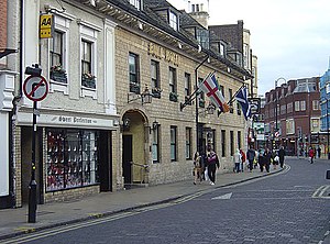
The Bull Hotel, Peterborough
Distance: Approx. 380 meters
Latitude and longitude: 52.57472222,-0.2425
The Bull Hotel is a 17th-century AA 4-star hotel in the Westgate neighbourhood of Peterborough, Cambridgeshire, opposite the Queensgate shopping centre. The Bull Hotel, a Grade II listed building, is the premier hotel in Peterborough, and is the only AA recognised 4 star hotel in the city centre. It has served as a notable conference location for middle England, with a capacity of 250.

St John the Baptist Church, Peterborough
Church in Cambridgeshire, England
Distance: Approx. 282 meters
Latitude and longitude: 52.5727,-0.2439
St John the Baptist Church is a Grade I listed Church of England parish church in the city of Peterborough, now Cambridgeshire, England.
Peterborough Crescent railway station
Former railway station in England
Distance: Approx. 142 meters
Latitude and longitude: 52.5726,-0.2491
Peterborough Crescent was a railway station serving the city of Peterborough, England. The station opened in 1858 but closed in 1866. The station was served by Midland Railway from the Ely to Peterborough Line.
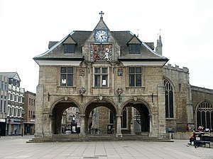
Peterborough Guildhall
Municipal building in Peterborough, Cambridgeshire, England
Distance: Approx. 337 meters
Latitude and longitude: 52.5726,-0.2431
The Guildhall is a municipal building in Cathedral Square, Peterborough, Cambridgeshire, England. It is a Grade II* listed building.
Weather in this IP's area
scattered clouds
25 Celsius
25 Celsius
24 Celsius
26 Celsius
1024 hPa
38 %
1024 hPa
1022 hPa
10000 meters
4.12 m/s
230 degree
40 %
05:14:41
21:00:03