Country:
 Iceland
Region:
City:
Latitude and Longitude:
Time Zone:
Postal Code:
IP information under different IP Channel
ip-api
Country
Region
City
ASN
Time Zone
ISP
Blacklist
Proxy
Latitude
Longitude
Postal
Route
IPinfo
Country
Region
City
ASN
Time Zone
ISP
Blacklist
Proxy
Latitude
Longitude
Postal
Route
MaxMind
Country
Region
City
ASN
Time Zone
ISP
Blacklist
Proxy
Latitude
Longitude
Postal
Route
Luminati
Country
ISASN
Time Zone
Atlantic/Reykjavik
ISP
Ljosleidarinn ehf
Latitude
Longitude
Postal
db-ip
Country
Region
City
ASN
Time Zone
ISP
Blacklist
Proxy
Latitude
Longitude
Postal
Route
ipdata
Country
Region
City
ASN
Time Zone
ISP
Blacklist
Proxy
Latitude
Longitude
Postal
Route
Popular places and events near this IP address
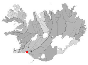
Árborg
Municipality in Southern Region, Iceland
Distance: Approx. 364 meters
Latitude and longitude: 63.93611111,-21
Sveitarfélagið Árborg (Icelandic pronunciation: [ˈsveiːtarˌfjɛːˌlaijɪð ˈaurˌpɔrk] ) is the biggest municipality in southern Iceland founded in 1998. The biggest town in the municipality is Selfoss. Eyrarbakki and Stokkseyri are two communities on the southern coast and Sandvíkurhreppur is a rural administrative region between those three other towns.
Ölfusá
River in Iceland
Distance: Approx. 6207 meters
Latitude and longitude: 63.98663056,-20.961525
The Ölfusá (Icelandic pronunciation: [ˈœlvʏsˌauː] ) is a river in Iceland. It begins at the junction between the Hvítá and Sog rivers, just north of the town of Selfoss, and flows for 25 km into the Atlantic Ocean. It is Iceland's largest river by volume with an average discharge of 423 m³/s.
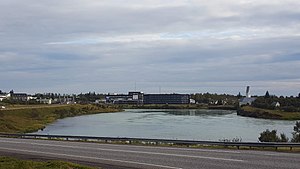
Selfoss (town)
Town in southern Iceland
Distance: Approx. 144 meters
Latitude and longitude: 63.93333333,-21
Selfoss (Icelandic pronunciation: [ˈsɛlˌfɔsː] ) is a town in southern Iceland on the banks of the Ölfusá river. It is the seat of the municipality of Árborg. The Icelandic Route 1 runs through the town on its way between Hveragerði and Hella.
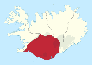
Southern Region (Iceland)
Region of Iceland
Distance: Approx. 9 meters
Latitude and longitude: 63.93305556,-20.99694444
Southern Region (Icelandic: Suðurland Icelandic pronunciation: [ˈsʏːðʏrˌlant] , lit. 'Southern Land') is a region of Iceland. The population of the region was 28,399 (1 January 2020). The largest town in the region is Selfoss, with a population of 9,683 as of 2022.
Laugardælir
Distance: Approx. 2399 meters
Latitude and longitude: 63.95,-20.96666667
Laugardælir (Icelandic pronunciation: [ˈlœyːɣarˌtaiːlɪr̥]) is a small settlement in southwest Iceland, near the town of Selfoss. The town gained international attention when former 1972 World Chess Champion Bobby Fischer was buried in the cemetery of Laugardælir Church in 2008.
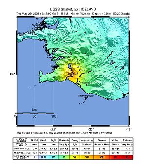
2008 Iceland earthquake
Doublet earthquake with composite magnitude of 6.1 Mw
Distance: Approx. 6609 meters
Latitude and longitude: 63.992,-21.014
The 2008 Iceland earthquake was a doublet earthquake that struck on 29 May at 15:46 UTC in southwestern Iceland. The recorded magnitudes of the two main quakes were 5.9 Mw and 5.8 Mw , respectively, giving a composite magnitude of 6.1 Mw . There were no human fatalities, but injuries were reported and a number of sheep were killed.
Kaldaðarnes
Distance: Approx. 8498 meters
Latitude and longitude: 63.93120278,-21.17077222
Kaldaðarnes is an ancient farm estate in Iceland on the banks of the Ölfus river, around 8 km (5.0 mi) west of Selfoss. Records of a farm at this location exist back to year 1200 AD where it is stated that Kaldaðarnes was one of few farms with rights to offer ferry service across the Ölfus river. At Kaldaðarnes there was a church during Middle Ages and in the church there was a wooden cross that was believed to have healing powers, drawing pilgrims to the church.
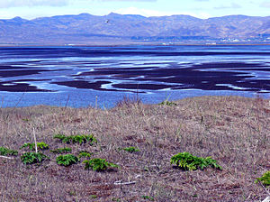
Flói Nature Reserve
Distance: Approx. 9950 meters
Latitude and longitude: 63.899,-21.185
The Flói Nature Reserve (Icelandic pronunciation: [ˈflouːɪ]) is a bird and nature reserve located near Árborg municipality in the Southern Region of Iceland. It includes a stretch of the east shore of the Ölfusá River. The reserve measures roughly 1–1.5 km (0.62–0.93 mi) wide by 4.5 km (2.8 mi) long, with an area of about 5 km2 (1.9 sq mi).
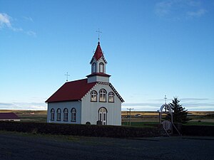
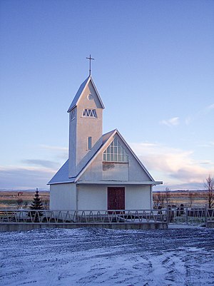
Hraungerðiskirkja
Distance: Approx. 8789 meters
Latitude and longitude: 63.9489,-20.821
Hraungerðiskirkja (Icelandic pronunciation: [ˈr̥œynˌcɛrðɪsˌcʰɪr̥ca]) is a Lutheran church in Flóahreppur, Iceland. The church was designed by Eiríkur Gíslason from Bitra in Hraungerðishreppur and built in 1902. It stands on the site of another former church that dated back to 1200 CE. It is a wooden church with a red roof.

Þjórsá Lava
Distance: Approx. 6240 meters
Latitude and longitude: 63.9,-21.1
The Great Þjórsá Lava (Icelandic: Þjórsárhraunið mikla [ˈθjour̥sˌaur̥ˌr̥œyːnɪð ˈmɪhkla]) is the largest lava flow in Iceland (by both area and volume) and the largest lava flow that is known to have erupted in a single eruption in the Holocene. Þjórsá Lava has a total volume of more than 25 km3 (6.0 cu mi), covering approximately 900 km2 (350 sq mi). The Þjórsá Lava does not appear on the surface until 70 km (43 mi) downstream of its identified eruptive area.
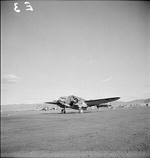
RAF Kaldadarnes
Former Royal Air Force station in Iceland
Distance: Approx. 8498 meters
Latitude and longitude: 63.93120278,-21.17077222
Royal Air Force Kaldadarnes or more simply RAF Kaldadarnes is a former Royal Air Force station at Kaldaðarnes, near the town of Selfoss, Iceland.

Ingólfsfjall
Volcano in Iceland
Distance: Approx. 5823 meters
Latitude and longitude: 63.9821,-21.0388
Ingólfsfjall (Icelandic pronunciation: [ˈiŋkoul(f)sˌfjatl̥]) is a 551-metre-high (1,808 ft) tuya in Iceland in the vicinity of Hveragerði.
Weather in this IP's area
overcast clouds
11 Celsius
11 Celsius
11 Celsius
11 Celsius
999 hPa
85 %
999 hPa
997 hPa
10000 meters
3.03 m/s
3.58 m/s
272 degree
100 %
04:18:30
22:42:14