Country:
 United Arab Emirates
Region:
City:
Latitude and Longitude:
Time Zone:
Postal Code:
IP information under different IP Channel
ip-api
Country
Region
City
ASN
Time Zone
ISP
Blacklist
Proxy
Latitude
Longitude
Postal
Route
IPinfo
Country
Region
City
ASN
Time Zone
ISP
Blacklist
Proxy
Latitude
Longitude
Postal
Route
MaxMind
Country
Region
City
ASN
Time Zone
ISP
Blacklist
Proxy
Latitude
Longitude
Postal
Route
Luminati
Country
AERegion
du
City
dubai
ASN
Time Zone
Asia/Dubai
ISP
Emirates Integrated Telecommunications Company PJSC
Latitude
Longitude
Postal
db-ip
Country
Region
City
ASN
Time Zone
ISP
Blacklist
Proxy
Latitude
Longitude
Postal
Route
ipdata
Country
Region
City
ASN
Time Zone
ISP
Blacklist
Proxy
Latitude
Longitude
Postal
Route
Popular places and events near this IP address

Fujairah International Airport
Airport in Emirate of Fujairah, UAE
Distance: Approx. 1798 meters
Latitude and longitude: 25.11222222,56.32416667
Fujairah International Airport (Arabic: مطار الفجيرة الدولي) (IATA: FJR, ICAO: OMFJ) is an international airport located 1 nautical mile (1.9 km; 1.2 mi) south of central Fujairah City. The airport has one terminal serving both passengers and cargo and is home to the Fujairah Aviation Academy.
Rugaylat
Place in Fujairah, United Arab Emirates
Distance: Approx. 867 meters
Latitude and longitude: 25.11666667,56.35
Rugaylat is a suburb of the city of Fujairah in the United Arab Emirates. The site of a small port, the area has seen a number of drownings of unwary swimmers.

University of Fujairah
University in Fujairah City, United Arab Emirates
Distance: Approx. 861 meters
Latitude and longitude: 25.121875,56.335361
The University of Fujairah (UOF) is a higher education institution in Fujairah City, capital city of Fujairah, United Arab Emirates. It was originally founded as Fujairah College in 2006. The foundation of the college was initiated by the members of the Fujairah Welfare Association (FWA).
Fujairah Club Stadium
Distance: Approx. 1541 meters
Latitude and longitude: 25.130082,56.34373
Fujairah Stadium is a multi-use stadium located in Fujairah, United Arab Emirates. It is currently used mostly for football matches and is the home ground of Fujairah SC. The stadium holds 10,645 people. The stadium was opened on May 1st, 1986 and renovated in 1993, 1995 and 2015.

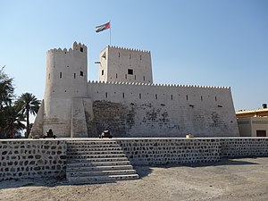
Fujairah Fort
16th century fort in the UAE
Distance: Approx. 2525 meters
Latitude and longitude: 25.138726,56.336978
Fujairah Fort (Arabic: قلعة الفجيرة) is a fort in the city of Fujairah, United Arab Emirates (UAE). Dating back to the 16th century, it is among the oldest as well as the largest castles in the country. It is noted for playing significant roles in fighting back the wave of colonialism.
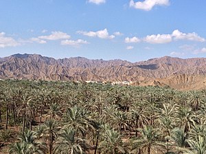
Fujairah
Capital of the Emirate of Fujairah, United Arab Emirates
Distance: Approx. 955 meters
Latitude and longitude: 25.12222222,56.33444444
Fujairah City (Arabic: الفجيرة) is the capital of the emirate of Fujairah in the United Arab Emirates. It is the seventh-largest city in UAE, located on the Gulf of Oman (part of the Indian Ocean). It is the only Emirati capital city on the UAE's east coast.

Sheikh Zayed Mosque, Fujairah
Distance: Approx. 1817 meters
Latitude and longitude: 25.12608056,56.32688056
The Sheikh Zayed Mosque, Fujairah (Arabic: مَسْجِد ٱلشَّيْخ زَايِد فِي ٱلْفُجَيْرَة, romanized: Masjid Aš-Šaykh Zāyid fil-Fujayrah), is the main mosque in the Emirate of Fujairah, and the second largest in the U.A.E. after the mosque with the same name in Abu Dhabi.
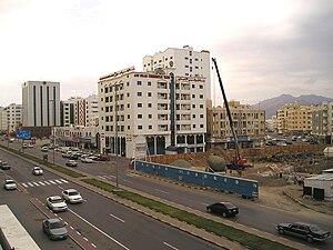
Hamad Bin Abdulla Road
Road in Fujairah City, United Arab Emirates
Distance: Approx. 983 meters
Latitude and longitude: 25.122325,56.33416625
Hamad Bin Abdulla Road is the main road running east–west through Fujairah City, Emirate of Fujairah, United Arab Emirates. Hamad Bin Abdulla Road is a hub for the business and commercial centre of Fujairah City. It is lined with tall office buildings (e.g., Fujairah Tower) and hotels.

Fujairah Corniche
Distance: Approx. 1761 meters
Latitude and longitude: 25.121281,56.358022
The Fujairah Corniche is a seafront corniche located at the east end of Hamad Bin Abdulla Road in Fujairah City, Emirate of Fujairah, United Arab Emirates, providing recreational facilities for residents and visitors. It is on the coast of the Gulf of Oman in the Indian Ocean. Al Corniche Road runs along the main corniche seafront.

Fujairah International Marine Club
Marine club in UAE
Distance: Approx. 1954 meters
Latitude and longitude: 25.126902,56.356937
The Fujairah International Marine Club (FIMC, now rebranded as the Marine Sports Club) is a club dedicated to recreational boating in Fujairah City, Emirate of Fujairah, United Arab Emirates. FIMC was founded in 1999, with the patronage of Sheikh Hamad bin Mohammed Al Sharqi, the Ruler of Fujairah. Facilities include fishing trips, jet skiing and speed boats.

Wadi Ham
River
Distance: Approx. 2122 meters
Latitude and longitude: 25.12847222,56.35769444
Wadi Ham is a wadi, a seasonal watercourse, in the Hajar Mountains of Fujairah and Ras Al Khaimah, United Arab Emirates. The main wadi runs from Masafi towards Fujairah City, until it reaches the Wadi Ham Dam and the Gulf of Oman. The wadi is crossed by the Sharjah/Khor Fakkan road north of the village of Daftah, which is in Ras Al Khaimah and traditionally Mazari.
Kalba Fort
Castle in the United Arab Emirates
Distance: Approx. 2473 meters
Latitude and longitude: 25.13472222,56.35527778
Kalba Fort is an 18th century fort located inland of the coastal city of Kalba on the eastern seaboard of Sharjah, United Arab Emirates. It was restored as a museum and visitor attraction in April 2021.
Weather in this IP's area
broken clouds
34 Celsius
41 Celsius
34 Celsius
34 Celsius
996 hPa
75 %
996 hPa
995 hPa
6000 meters
3.09 m/s
120 degree
75 %
05:41:04
19:00:52