Country:
 United Arab Emirates
Region:
City:
Latitude and Longitude:
Time Zone:
Postal Code:
IP information under different IP Channel
ip-api
Country
Region
City
ASN
Time Zone
ISP
Blacklist
Proxy
Latitude
Longitude
Postal
Route
IPinfo
Country
Region
City
ASN
Time Zone
ISP
Blacklist
Proxy
Latitude
Longitude
Postal
Route
MaxMind
Country
Region
City
ASN
Time Zone
ISP
Blacklist
Proxy
Latitude
Longitude
Postal
Route
Luminati
Country
AERegion
az
City
abudhabi
ASN
Time Zone
Asia/Dubai
ISP
Emirates Integrated Telecommunications Company PJSC
Latitude
Longitude
Postal
db-ip
Country
Region
City
ASN
Time Zone
ISP
Blacklist
Proxy
Latitude
Longitude
Postal
Route
ipdata
Country
Region
City
ASN
Time Zone
ISP
Blacklist
Proxy
Latitude
Longitude
Postal
Route
Popular places and events near this IP address
Khawr al Baydah
Distance: Approx. 8115 meters
Latitude and longitude: 25.58333333,55.63333333
Khawr al Baydah is a bay in Umm al Quwain.
MV Dara
British passenger & cargo liner that traded in the Indian Ocean
Distance: Approx. 9015 meters
Latitude and longitude: 25.57472222,55.46611111
MV Dara was a British passenger ship, built in 1948 by Barclay, Curle & Co. Ltd., Glasgow, Scotland. She travelled mostly between the Persian Gulf and the Indian subcontinent, carrying expatriate passengers who were employed in the nations of the Gulf.
Tell Abraq
Archaeological site in the UAE
Distance: Approx. 9073 meters
Latitude and longitude: 25.48333333,55.55
Tell Abraq (Til Abrook) was an ancient Near Eastern city. Located on the border between Sharjah and Umm Al Quwain in the United Arab Emirates about 50 kilometers north-east of Dubai, the city was originally on the coastline of the Persian Gulf but changing sea levels have placed the remains of the city inland. It is located on the main road from Umm Al Quwain to Falaj Al Mualla.

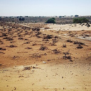
Umm Al Quwain
Capital and largest city of the Emirate of Umm Al Quwain, United Arab Emirates.
Distance: Approx. 1483 meters
Latitude and longitude: 25.55333333,55.5475
Umm Al Quwain (UAQ; Arabic: أم القيوين, pronounced: /ʔumː alqejˈwejn/, Gulf arabic: [ʔʊm͜ː 'æl ge̞ˈwe̞n],) is the capital and largest city of the Emirate of Umm Al Quwain in the United Arab Emirates. Its ruling royal family are the Al Mualla. The city is located on the peninsula of Khor Al Bidiyah, with the nearest major cities being Sharjah to the southwest and Ras Al Khaimah to the northeast.
Ed Dur
Ancient city and archaeological site in the UAE
Distance: Approx. 8549 meters
Latitude and longitude: 25.52222222,55.62611111
Ed Dur, also known as Al Dour and Ad Dour (Arabic: ٱلدُّوْر, romanized: Ad-Dūr, lit. 'The Houses') is an Ancient Near Eastern City, today located in Umm Al Quwain, in the United Arab Emirates (UAE). One of the largest archaeological sites in the emirates, comprising an area of some 5 km2 (1.9 sq mi), the coastal settlement overlooks Al Beidha Lake. One of the most important archaeological finds in the UAE, and closely associated with the inland trading centre of Mleiha, Ed Dur has been dubbed 'one of the most significant lost cities of Arabia'.
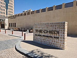
Al Bait Hotel
Hotel in Sharjah, United Arab Emirates
Distance: Approx. 9557 meters
Latitude and longitude: 25.59833333,55.64277778
The Chedi Al Bait Hotel is a 53-room five star heritage hotel situated in the Heart of Sharjah cultural heritage area in Sharjah, United Arab Emirates – a restoration of the traditional trading and residential district of Sharjah town.

Siniyah Island
Island in the United Arab Emirates
Distance: Approx. 9711 meters
Latitude and longitude: 25.61472222,55.63444444
Siniyah Island (Jazīrat as Sīnīyah, Arabic: جزيرة السينية) is a natural island situated off the coast of the Emirate of Umm Al Quwain in the United Arab Emirates (UAE). It is the site of the oldest pearl fishing town in the Persian Gulf, as well as of an Eastern Christian Monastery and Bishop's Palace. The island's name means 'flashing lights', thought to be a reference to the harsh sunlight of the area.
Umm Al Quwain Museum
National museum in Umm Al Quwain, United Arab Emirates
Distance: Approx. 2671 meters
Latitude and longitude: 25.5842,55.5707
Umm Al Quwain Museum, also known as UAQ National Museum or Umm Al Quwain National Museum, is a museum founded by Sheikh Rashid bin Majid Al Mualla. It is located in an old souq area called Madeena Al Qadeema in the city of Umm Al Quwain, United Arab Emirates, in an old fort that was once home to the ruling family. The fort acted as government headquarters in the years 1768 to 1969 until Al Mualla renovated and transformed it into a museum.
Jazīrat Al Aki'āb
Distance: Approx. 3520 meters
Latitude and longitude: 25.54583333,55.58333333
Jazīrat Al Aki‘āb (Arabic: جزيرة الاكعاب, romanized: jazīrat-al-aki‘āb, "Heels Island") is an island in Umm Al Quwain, an emirate of the United Arab Emirates. It is one of seven islands located in the emirate, and people visit it to engage in a variety of activities such as birdwatching, camping, diving, snorkeling and other recreational ventures.
Weather in this IP's area
overcast clouds
35 Celsius
42 Celsius
35 Celsius
35 Celsius
994 hPa
82 %
994 hPa
994 hPa
10000 meters
2.78 m/s
3.74 m/s
189 degree
89 %
05:43:28
19:04:46