Country:
 United Arab Emirates
Region:
City:
Latitude and Longitude:
Time Zone:
Postal Code:
IP information under different IP Channel
ip-api
Country
Region
City
ASN
Time Zone
ISP
Blacklist
Proxy
Latitude
Longitude
Postal
Route
IPinfo
Country
Region
City
ASN
Time Zone
ISP
Blacklist
Proxy
Latitude
Longitude
Postal
Route
MaxMind
Country
Region
City
ASN
Time Zone
ISP
Blacklist
Proxy
Latitude
Longitude
Postal
Route
Luminati
Country
AERegion
sh
City
sharjah
ASN
Time Zone
Asia/Dubai
ISP
Emirates Integrated Telecommunications Company PJSC
Latitude
Longitude
Postal
db-ip
Country
Region
City
ASN
Time Zone
ISP
Blacklist
Proxy
Latitude
Longitude
Postal
Route
ipdata
Country
Region
City
ASN
Time Zone
ISP
Blacklist
Proxy
Latitude
Longitude
Postal
Route
Popular places and events near this IP address

Khor Fakkan
City in Sharjah, United Arab Emirates
Distance: Approx. 836 meters
Latitude and longitude: 25.33333333,56.35
Khor Fakkan (Arabic: خَوْر فَكَّان, romanized: Khawr Fakkān) is a city and an exclave of the Emirate of Sharjah, located on the east coast of the United Arab Emirates (UAE), facing the Gulf of Oman, and geographically surrounded by the Emirate of Fujairah. The city, the second largest on the east coast after Fujairah City, is set on the bay of Khor Fakkan, which means "Creek of Two Jaws". It is the site of Khor Fakkan Container Terminal, the only natural deep-sea port in the region and one of the major container ports in the UAE. The Port of Khor Fakkan faces the Emirate of Sharjah’s eastern seaboard, extending connections with Asia and the Far East.
Najd Al Miqsar
Place in Sharjah, United Arab Emirates
Distance: Approx. 4710 meters
Latitude and longitude: 25.35,56.3
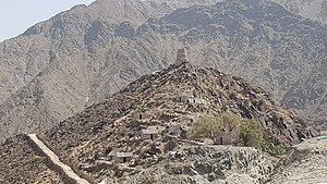
Najd Al Miqsar is an abandoned settlement West of Khor Fakkan in Sharjah, United Arab Emirates (UAE), now a heritage village and popular tourist spot. A traditional village at the head of the Wadi Shie, which is dammed by the Al Rafisah Dam, Najd Al Miqsar was restored as a heritage village following the construction of the Sharjah-Khor Fakkan highway and the dam and associated rest area that were developed as part of the Dhs5.5 billion highway project. The fort at Najd Al Miqsar formed part of a connected series of fortifications protecting Khor Fakkan, which included the Al Rabi Tower and the Al Adwani Tower.
Hayawa
Place in Sharjah, United Arab Emirates
Distance: Approx. 3269 meters
Latitude and longitude: 25.36,56.34888889
Hayawa is the name of a suburb of Khor Fakkan, in Sharjah, United Arab Emirates (UAE).
Mudaifi
Place in Sharjah, United Arab Emirates
Distance: Approx. 3391 meters
Latitude and longitude: 25.36166667,56.34472222
Mudaifi is a suburb of the town of Khor Fakkan in Sharjah, United Arab Emirates (UAE).
Qidfa
Place in Fujairah, United Arab Emirates
Distance: Approx. 3853 meters
Latitude and longitude: 25.3,56.35833333
Qidfa is a settlement and oasis in Fujairah, United Arab Emirates (UAE). It is the site of the Fujairah power and desalination plant, the largest in the UAE. Qidfa Oasis is the location of a Wadi Suq period (2,000 to 1,300 BCE) burial, a distinctive horse-shoe shaped tomb which is displayed at the Fujairah National Museum. The find at Qidfa was unusual in that the site yielded hundreds of weapons and vessels, including longswords, bows and arrows.

Fujairah F1 IWPP
IWPP facility in the United Arab Emirates
Distance: Approx. 3621 meters
Latitude and longitude: 25.31444444,56.37277778
Fujairah F1 Independent Water and Power Plant or Fujairah F1 IWPP is an independent water and power plant (IWPP) at Qidfa', Fujairah in the United Arab Emirates. It is located next to the Fujairah F2 IWPP. It is 5 kilometres (3.1 mi) south of Khor Fakkan and 20 kilometres (12 mi) north of the city of Fujairah. When constructed, the Fujairah plant was the first hybrid plant in the Middle East, and the largest desalination hybrid plant in the world.
Fujairah F2 IWPP
Distance: Approx. 4502 meters
Latitude and longitude: 25.30194444,56.37277778
Fujairah F2 Independent Water and Power Plant or Fujairah F2 IWPP is an independent water and power plant (IWPP) at Qidfa', Fujairah in the United Arab Emirates. It is located next to the Fujairah F1 IWPP plant south of Khor Fakkan and north of the city of Fujairah. During inauguration, it was the largest desalination plant in the United Arab Emirates.
Wadi Shis
Place in Sharjah, United Arab Emirates
Distance: Approx. 3291 meters
Latitude and longitude: 25.35,56.31666667
Wadi Shis is a wadi, a seasonal watercourse, in the Hajar Mountains of Sharjah, United Arab Emirates. The wadi passes through the mountain village of Shis, before making its way through the Omani exclave of Madha, the Emirati exclave of Nahwa (part of Sharjah), through Madha again and down to the east coast. Like many of the wadis of the Hajar Mountains, Shis can be dangerous during and following periods of rain and in 2020 four UAE nationals lost their cars to flash-floods in the wadi.
Al Rafisah Dam
Place in Sharjah, United Arab Emirates
Distance: Approx. 4710 meters
Latitude and longitude: 25.35,56.3
Al Rafisah Dam (Arabic: سدّ اٱرَّفِيْصَة, romanized: Sudd Ar-Rafīṣah) is a dam in Sharjah, United Arab Emirates. It dams the Wadi Shie, a seasonal waterway in the Hajar Mountains that runs down to the city of Khor Fakkan on the east coast of Sharjah.
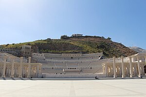
Khor Fakkan Amphitheatre
Distance: Approx. 4105 meters
Latitude and longitude: 25.36784,56.34748
The Khor Fakkan Amphitheatre is an amphitheatre and a cultural landmark in the Emirate of Sharjah, located in Khor Fakkan.

Wadi Shie
River
Distance: Approx. 2318 meters
Latitude and longitude: 25.34736111,56.32733333
Wadi Shie is a seasonal watercourse located in the Eastern Hajar Mountains of Sharjah, in the United Arab Emirates. The wadi runs from the mountains down to meet the coastal city of Khor Fakkan on the Gulf of Oman and is dammed above the restored heritage village of Najd Al Miqsar by the Al Rafisah Dam, a popular tourist spot. Below the dam is the restored hillside heritage village and fort of Najd Al Miqsar.
Al Suhub Rest House
Tourist attraction in the United Arab Emirates
Distance: Approx. 3720 meters
Latitude and longitude: 25.36046,56.32394
The Al Suhub Rest House is a tourist attraction in Khor Fakkan, on the East Coast of the Emirate of Sharjah, United Arab Emirates. Located on top of mountains overlooking the city, and forming its highest point, the circular building offers panoramic views of Khor Fakkan and the Gulf of Oman.
Weather in this IP's area
broken clouds
36 Celsius
43 Celsius
36 Celsius
36 Celsius
995 hPa
51 %
995 hPa
992 hPa
10000 meters
1.97 m/s
1.6 m/s
63 degree
66 %
05:40:13
19:01:46