Country:
 Lithuania
Region:
City:
Latitude and Longitude:
Time Zone:
Postal Code:
IP information under different IP Channel
ip-api
Country
Region
City
ASN
Time Zone
ISP
Blacklist
Proxy
Latitude
Longitude
Postal
Route
IPinfo
Country
Region
City
ASN
Time Zone
ISP
Blacklist
Proxy
Latitude
Longitude
Postal
Route
MaxMind
Country
Region
City
ASN
Time Zone
ISP
Blacklist
Proxy
Latitude
Longitude
Postal
Route
Luminati
Country
LTRegion
mr
City
marijampole
ASN
Time Zone
Europe/Vilnius
ISP
UAB Cgates
Latitude
Longitude
Postal
db-ip
Country
Region
City
ASN
Time Zone
ISP
Blacklist
Proxy
Latitude
Longitude
Postal
Route
ipdata
Country
Region
City
ASN
Time Zone
ISP
Blacklist
Proxy
Latitude
Longitude
Postal
Route
Popular places and events near this IP address
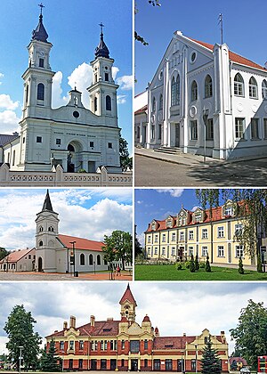
Marijampolė
City in Suvaljika Region, Lithuania
Distance: Approx. 2168 meters
Latitude and longitude: 54.54722222,23.35
Marijampolė (; also known by several other names) is the capital of the Marijampolė County in the south of Lithuania, bordering Poland and Russian Kaliningrad Oblast, and Lake Vištytis. The city's population stood at approximately 48,700 in 2003. It is the cultural centre and largest settlement of the historical region of Suvalkija (Sudovia).
Marijampolė County
County of Lithuania
Distance: Approx. 901 meters
Latitude and longitude: 54.55861111,23.34944444
Marijampolė County (Lithuanian: Marijampolės apskritis) is one of the ten counties in Lithuania. It is in the southwest of the country and roughly corresponds to the historical region of Sudovia. Its capital and the largest town is Marijampolė.

Marijampolė Municipality
Municipality in Suvalkija, Lithuania
Distance: Approx. 941 meters
Latitude and longitude: 54.56,23.35888889
Marijampolė Municipality (Lithuanian: Marijampolės savivaldybė) is a municipality in Marijampolė County, south-western Lithuania. Its administrative seat and largest town is Marijampolė. It borders Lazdijai District Municipality and Alytus District Municipality to the south-east, Prienai District Municipality to the east, Vilkaviškis District Municipality to the west, Kazlų Rūda Municipality to the north and Kalvarija Municipality to the south.

Sūduva Stadium
Mixed-use playground in Lithuania
Distance: Approx. 1323 meters
Latitude and longitude: 54.57454722,23.36539167
Marijampolė Football Arena, also referred to as Hikvision Arena or Sūduva Stadium, is a multi-purpose stadium in Marijampolė, Lithuania. It is currently used mostly for football matches and is the home stadium of Sūduva.

Dovinė
River in Alytus County, Lithuania
Distance: Approx. 8408 meters
Latitude and longitude: 54.492,23.3692
The Dovinė is a river of Marijampolė County and Alytus County, in southern Lithuania. The 47 kilometres (29 mi) Dovinė has a basin area of 588.7 km2. It is a right tributary of the river Šešupė.
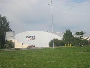
Marijampolė Football Indoor Arena
Arena in Lithuania
Distance: Approx. 1499 meters
Latitude and longitude: 54.57555556,23.3675
Marijampolė Football Indoor Arena is indoor arena in Marijampolė, Lithuania, mainly used for football. For sponsorship reasons from 2011 to December 2019 was called ARVI maniežas (Indoor Arena). Between the 2011 and 2019 seasons the stadium was named ARVI Football Arena after the sponsoring rights were bought by ARVI Enterprises Group.
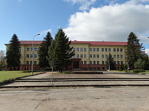
Marijampolė Gymnasium
Secondary school in Marijampolė, Lithuania
Distance: Approx. 748 meters
Latitude and longitude: 54.56,23.34916667
Marijampolė Rygiškių Jonas Gymnasium (Lithuanian: Marijampolės Rygiškių Jono gimnazija) is a secondary school in Marijampolė, Lithuania. It is named after Rygiškių Jonas, one of the pen names of linguist Jonas Jablonskis who was one of the gymnasium's alumni. Established in 1867, the gymnasium was a significant cultural center of Suvalkija and educated many prominent figures of the Lithuanian National Revival.
Marijampolė Free Economic Zone
Distance: Approx. 3561 meters
Latitude and longitude: 54.57985361,23.40030917
Marijampolė Free Economic Zone or Baltic FEZ (Lithuanian: Marijampolės laisvoji ekonominė zona) is a special economic zone located in Marijampolė, Lithuania. It has 77.73 ha area, which was established in 2011 December 23 near European route E67 and Rail Baltica. The zone was established for 49 years, specialize in four industries: Science, Forestry, Metalworking and Food processing, and is oriented to the investors from Scandinavian countries.
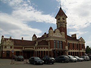
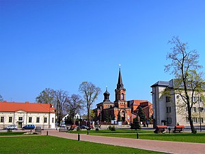
Marijampolė railway station
Railway station in Marijampolė, Lithuania
Distance: Approx. 1408 meters
Latitude and longitude: 54.55722222,23.36444444
Marijampolė railway station (Lithuanian: Marijampolės geležinkelio stotis) is one of the most ornate buildings of its type in Lithuania. It was designed by Edmundas Frykas in Art Deco architectural style.
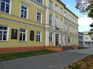
Marijampolė University of Applied Sciences
Institution of higher education in Marijampolė, Lithuania
Distance: Approx. 3776 meters
Latitude and longitude: 54.53277778,23.35055556
Marijampolė University of Applied Sciences (Lithuanian: Marijampolės kolegija, MARKO) is an institution of higher education located in Marijampolė, Lithuania. It was established in 2001 after merger of Marijampole Pedagogical High School, and Marijampole Agricultural High School. The university offers 9 undergraduate and 2 post-graduate courses.
Marijampolė Realgymnasium
Distance: Approx. 811 meters
Latitude and longitude: 54.55944444,23.35111111
Marijampolė Realgymnasium (Lithuanian: Marijampolės realinė gimnazija) was a private gymnasium (secondary school) in Marijampolė, Lithuania. Established at the end of 1918, it employed many teachers sympathetic to socialist and communist causes. The Communist Party of Lithuania and other communist organizations were outlawed and actively persecuted in interwar Lithuania.
Weather in this IP's area
overcast clouds
19 Celsius
19 Celsius
19 Celsius
19 Celsius
1015 hPa
66 %
1015 hPa
1007 hPa
10000 meters
2.45 m/s
4.09 m/s
221 degree
100 %
05:30:59
21:34:58