Country:
 Lithuania
Region:
City:
Latitude and Longitude:
Time Zone:
Postal Code:
IP information under different IP Channel
ip-api
Country
Region
City
ASN
Time Zone
ISP
Blacklist
Proxy
Latitude
Longitude
Postal
Route
IPinfo
Country
Region
City
ASN
Time Zone
ISP
Blacklist
Proxy
Latitude
Longitude
Postal
Route
MaxMind
Country
Region
City
ASN
Time Zone
ISP
Blacklist
Proxy
Latitude
Longitude
Postal
Route
Luminati
Country
LTRegion
ku
City
kaisiadorys
ASN
Time Zone
Europe/Vilnius
ISP
UAB Cgates
Latitude
Longitude
Postal
db-ip
Country
Region
City
ASN
Time Zone
ISP
Blacklist
Proxy
Latitude
Longitude
Postal
Route
ipdata
Country
Region
City
ASN
Time Zone
ISP
Blacklist
Proxy
Latitude
Longitude
Postal
Route
Popular places and events near this IP address
Kaišiadorys District Municipality
District Municipality in Aukštaitija, Lithuania
Distance: Approx. 770 meters
Latitude and longitude: 54.86027778,24.45444444
Kaišiadorys District Municipality is one of 60 municipalities in Lithuania.
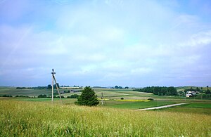
Kaišiadorys
City in Aukštaitija, Lithuania
Distance: Approx. 4 meters
Latitude and longitude: 54.86666667,24.45
Kaišiadorys ([kɐɪɕɛˈdôːrʲiːs] , German: Koschedaren) is a city in central Lithuania. It is situated between Vilnius and Kaunas. Kaišiadorys is one of six Lithuanian diocese centres.

Žiežmariai
Town in Aukštaitija, Lithuania
Distance: Approx. 7425 meters
Latitude and longitude: 54.8,24.45
Žiežmariai () is a town in the Kaišiadorys district municipality, Lithuania. It is located 6 km (3.7 mi) south of Kaišiadorys. The center of Žiežmariai is a state-protected urbanistic monument.

Battle of Strėva
1348 battle
Distance: Approx. 7726 meters
Latitude and longitude: 54.8,24.41666667
The Battle of Strėva, Strebe, or Strawe was fought on 2 February 1348 between the Teutonic Order and the pagan Grand Duchy of Lithuania on the banks of the Strėva River, a right tributary of the Neman River, near present-day Žiežmariai. Chronicler Wigand of Marburg publicized this battle as a great victory for the Knights: he claims that some 18,000 Lithuanians were killed or drowned while only 8 knights and 60 other soldiers died on the Order's side. Narimantas and Manvydas, two sons of Gediminas, Grand Duke of Lithuania, are thought to be killed in the battle.

Roman Catholic Diocese of Kaišiadorys
Roman Catholic diocese in Lithuania
Distance: Approx. 1859 meters
Latitude and longitude: 54.85,24.45
The Roman Catholic Diocese of Kaišiadorys (Latin: Kaisiadorensis) is a diocese located in the city of Kaišiadorys in the Ecclesiastical Province of Vilnius in Lithuania. It was established on 4 April 1926 from the Metropolitan Archdiocese of Vilnius.
Žasliai
Town in Aukštaitija, Lithuania
Distance: Approx. 8903 meters
Latitude and longitude: 54.86388889,24.58888889
Žasliai (Polish: Żośle, Yiddish: זאָסלע Zosle) is a small town in Kaunas County in central Lithuania. In 2011, it had a population of 644. The town was first mentioned in written sources in 1457 and was granted the Magdeburg rights and its own coat of arms in 1792.
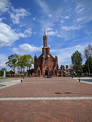
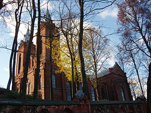
Transfiguration Cathedral, Kaišiadorys
Church in Kaišiadorys, Lithuania
Distance: Approx. 826 meters
Latitude and longitude: 54.86055556,24.45722222
The Cathedral of the Transfiguration of Our Lord (Lithuanian: Kristaus Atsimainymo katedra) also called Kaišiadorys Cathedral is the name given to a Catholic religious building that serves as the Cathedral of Kaišiadorys, a city of the European country of Lithuania, and the seat of the Diocese of Kaišiadorys. In 1906 a committee for the construction of the church was created. In the following years three different projects for the construction of the structure were developed.

Žasliai railway disaster
1975 railway incident in Lithuania
Distance: Approx. 9885 meters
Latitude and longitude: 54.83472222,24.59388889
Žasliai railway disaster occurred on 4 April 1975 near Žasliai, Lithuanian SSR. A passenger train on Vilnius–Kaunas Railway hit a tank car carrying fuel. The passenger train derailed and caught fire. Soviet authorities suppressed the news of the disaster and there are persistent rumors that the official death toll of 20 dead and 80 injured is understated, but it remains the largest railway accident in Lithuania.
Weather in this IP's area
overcast clouds
21 Celsius
21 Celsius
21 Celsius
22 Celsius
1015 hPa
67 %
1015 hPa
1006 hPa
10000 meters
1.79 m/s
1.91 m/s
197 degree
97 %
05:23:23
21:33:47